

**35.63 ACRES * 40 X 60 SHOP/BARN * PRIVACY * MATURE TREES * GREAT HUNTING
Tract 23 Pack Saddle Trail, Hulett, WY | Lat/Lng: 44.9634, -104.4335
$359,000
35.64 ac.
07/26/2026
PENDING
Description
Final Sale Price: No price given
Listed Price: $359,000
Date Listed: 07/26/2026
35.63 Acres - Off-Grid with Shop/Barn in one of the Wyoming Black Hills most scenic and secluded settings.
LOCATION - 4 Miles south of Alzada Montana and 26 miles north of Hulett, WY off Hwy 112.
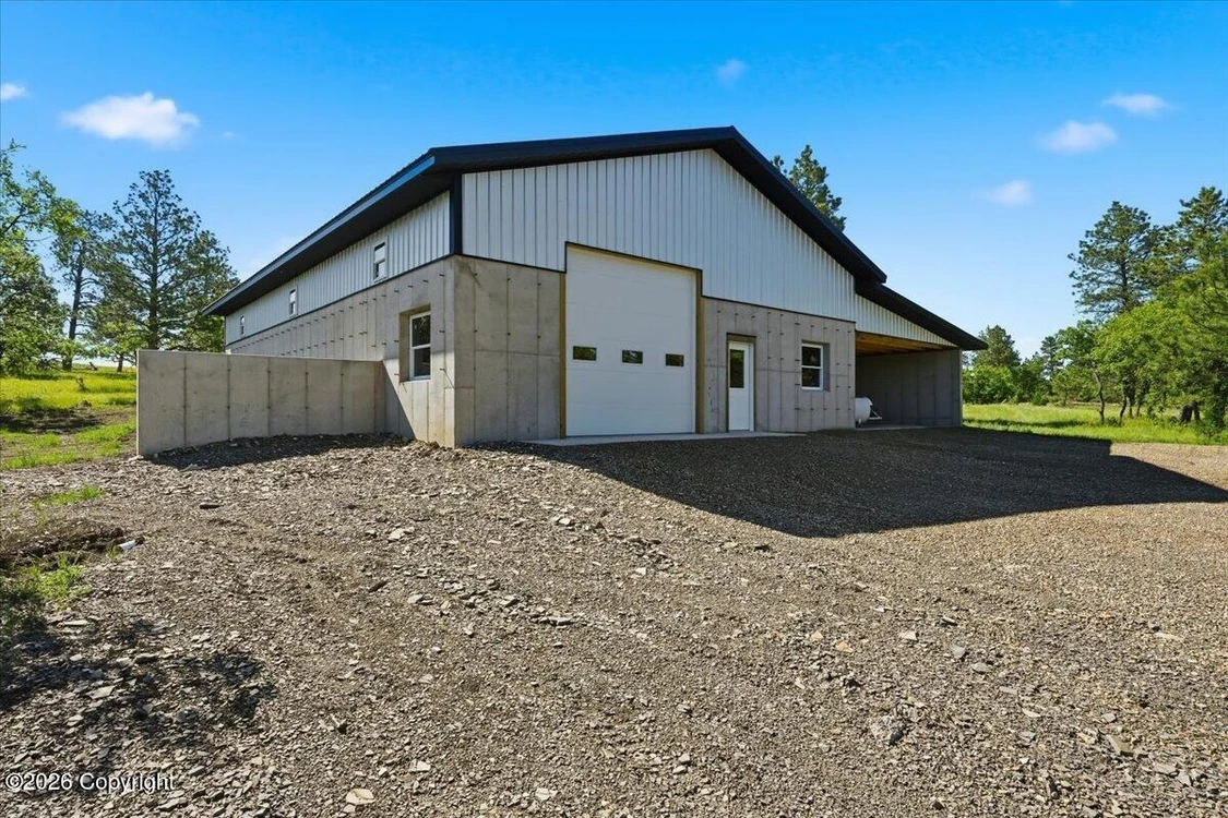
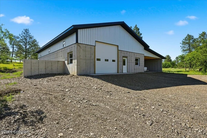
EXISTING STRUCTURE- A 40' x 60' shop/barn constructed with 8" thick concrete walls. This building was built to LAST FOREVER, constructed with over 100 yards of concrete. Inside the shop is a walled off area that measures 12' x 32'. The space has a wood burning stove and is ready to be customized by the new owner for living quarters or whatever use is needed. The shop also features an additional covered parking/storage that was designed with the option to be fully enclosed.
PROPERTY FEATURES - Mostly forested gentle rolling topography with mature Ponderosa Pine and Burr Oak interspersed with open grassy areas with many suitable locations for your house, cabin and additional structures.
HUNTING / WILDLIFE ON THE PROPERTY - Include mule deer, whitetail deer, elk & Merriam's turkey.
HUNTING OPPORTUNITIES on the public lands in Crook County include Elk, Whitetail Deer, Mule Deer, Antelope, Merriam's Turkey, Sharp Tailed Grouse & Roughed Grouse as well as waterfowl and other small game
species. From the property, you are approximately 45 minutes from access to 90,000+ acres of National Forest for additional hunting & fishing opportunities as well many other allowable outdoor activities. Crook County also has tens of thousands of additional acres of both BLM and WY State Lands that are also available to the public for hunting, hiking and many other outdoor recreational activities and you have dozens of these types of properties with public access within 15 minutes from the property
Hunting, hiking, riding horses & ATVs are just a few of the recreational opportunities in the immediate area.
SERVICES NEAR BY - ALZADA MT - Located just 4 miles north of the property. Alzada has limited services provided by a convenience store with fuel and limited groceries as well as a post office and the historic Stoneville Saloon where you can quench your thirst and grab a bite to eat. This is a must visit destination every year for many of the seasonal motorcyclist that tour this beautiful area of the Black Hills yearly.
HULETT WY - Located just 26 miles south of the property. You'll have access to a full-service grocery store, restaurants/bars, banking, hardware store, post office, multiple medical clinics, hotels, RV parks, K-12 school, and any other services, while still enjoying the privacy and solitude that make Pine Island such a sought-after destination.
THE GOLF CLUB AT DEVILS TOWER & 77 STEAKHOUSE & SALOON is also located in Hulett. This is a destination golf course that brings golfers from all over the world to enjoy the scenic yet challenging course. You do not have to be a golfer to take advantage of the 77 Steakhouse restaurant and Saloon which is open to the public where you can enjoy everything from a great 1/2-pound burger to a Tomahawk steak and everything in between.
HULETT MUNICIPAL AIRPORT-W43 - This airport is located on plateau above town and features a modern 5,500' paved runway for private planes as well as limited charter service.
VERY LIMITED COVENANTS - That help preserve the natural beauty of the area and protect long-term property values while allowing owners the freedom to enjoy their land.
*** WYOMING BIG GAMES HUNTING & TAGS ***
YOU MUST REFER TO THE WYOMING GAME AND FISH SITE FOR CURRENT DETAILED GUIDELINES:
HERE'S SOME GENERAL INFORMATION: FOR NON-RESIDENTS - Tags for Deer, Elk & Antelope must be obtained through the Wyoming Draw System. Once you draw your tag, you can obtain an additional archery license for $72.00 which allows you to also hunt during the designated archery season dates. If you do not fill your tag during archery season, you can continue to hunt during the designated rifle season for that specific unit and species which is unique because in most western states, your tag is restricted to either rifle OR archery season dates. Wyoming also allows crossbows during their archery hunting season.
ONCE YOU BECOME A WYOMING RESIDENT - Based on current regulations for Crook County, you can buy both your General Deer tag and Either-sex Elk Tag over the counter, which is a wonderful thing.
Below is general information based on previous years. (YOU MUST REFER TO WYG&F FOR CURRENT REG's)
ELK UNIT 116 - Archery Only dates Sept. 1st thru Sept. 30th ** Rifle Season Oct. 15th thru Nov. 10th
Cow Elk are also available in the draw and those dates generally run from Oct. 11th thru October. 30th
Cow Elk TYPE 8 License - This license type is ONLY VALID ON PRIVATE LAND, and the quantity of tags is UNLIMITED, so an individual can legally harvest multiple cow elk in a single season. The season dates are lengthy, generally running from Aug. 1st thru Jan. 31st. Many area outfitters do offer guided hunts for Cow Elk on private land in Crook County.
DEER REGION A - UNIT 2 - Archery Only dates Sept. 1st thru Sept. 30th ** Rifle Season Nov. 1st thru Nov. 20th
Deer tags are not species specific in this area. You can legally tag a either a Whitetail or Mule Deer.
ANTELOPE - UNIT 2 - Archery Only Aug. 15th thru Sept. 30th ** Rifle Season Oct. 1st thru Nov. 20th
MERRIAM'S TURKEY - Non- Res tags are available via the Draw System for both spring and fall.
MOUNTAIN LION TAGS are available over the counter. Harvest is based on a quota system. See the WG&F site for complete regulations.
TRAVELING TO AREA ATTRACTIONS:
Hulett WY - 27 miles
Golf Course at Devils Tower & 77 Steakhouse - 27 Miles
Devils Tower National Monument - 37 Miles
Cook Lake Recreation Area - 45 Miles
Keyhole Reservoir State Park WY - 71 Miles
Belle Fourche SD - 45 Miles
Spearfish SD - 57 Miles
Terry Peak Ski Area, Lead SD - 77 Miles
Blackhills Airport - Clyde Ice Field in Spearfish SD - 60 Miles
Sundance WY - 64 Miles
Sturgis SD - 70 Miles
Deadwood SD - 67 Miles
Gillette WY Regional Airport - 96 Miles
Rapid City SD Regional Airport - 108 Miles
Mount Rushmore National Monument - 120 Miles
Custer State Park - 120 Miles
Jewel Cave National Monument- 132 Miles
Wind Cave National Park 140 Miles
Badlands National Park - 155 Miles
Bighorn National Forest - 175 Miles
Sheridan WY - 200 Miles
Teodore Roosevelt National Park, Medora ND - 188 Miles
Yellowstone National Park - 386 Miles
Details
County: Crook
Zipcode: 82720
Property Type One: Recreational Property
Property Type Two: Residential Property
Property Type Three: Hunting Land
Brokerage: Properties West Realty Team Brokered by eXp Realty
Brokerage Link: www.propertieswestrealty.com

Paul Harris
Properties West Realty Team Brokered by eXp Realty
(605) 569-3838
By clicking the button, you agree to our Terms of Use and Privacy Policy.


Nearby Listings
Crook County, WY

$4,700,000 - 980 ac.
Crook County, WY
$749,000 - 52 ac.
Crook County, WY
$689,000 - 47 ac.
Butte County, SD
$12,889,448 - 1308 ac.
Crook County, WY
$4,450,000 - 520 ac.
Crook County, WY

$6,750,000 - 2422 ac.
Crook County, WY
$320,580 - 36 ac.
Butte County, SD

$7,240,000 - 906 ac.
Butte County, SD
$54,000 - 40 ac.
Crook County, WY

$925,000 - 55 ac.