National Land For Sale (91683 results)
Want to post your listings on AcreValue? View Listing Plans
AcreValue offers multiple types of land for sale in every state in America, so if you’re looking for a new ranch, farm, recreational property, hunting ground, developmental property, or land investment you’ve come to the right place. Regardless of what your needs or objectives are for your land, we have a large inventory of available parcels that are updated regularly. Therefore, it’s very likely that we have the perfect parcel that meets all the search criteria & specifications that you’ve been searching for. Additionally, because our land for sale listings are always being updated due to the frequency of land being sold or new land listings being put on the market, make sure that you are checking back with AcreValue regularly for updates. When you find the perfect land parcel and you are ready to take the next steps you can easily connect directly with the listing agent to help you facilitate your land purchase. We wish you the best of luck in finding your next ranch, farm, recreational property, hunting ground, developmental property, or land investment.

09/20/2025
$9,997
5.21 ac.
ACTIVE
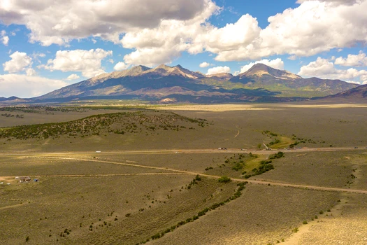
Costilla County - 0 McDonnell Rd, Fort Garland, CO
*** 5-Day Become A Landowner Challenge: Start With Easy Owner Financing ***
Over 600 people have already done this, will you be next?
Here's the plan:
Day 1: Book Your Free Meeting to Unlock Exclusive Offers
- Let's explore your land options together and unlock exclusive offers you won't find online. Go to: book.gokcap. com
Day 2: Place the Property on Hold
- Hold your property on our website so no one else can grab it, you're officially on the path to becoming a landowner.
Day 3: Explore Your Land
- Step onto your land, even virtually, do your homework, and imagine how you'll make it your own.
Day 4: Pick Your Path
- Choose the payment plan that's right for you, with 5% cash back rewards, 9 free bonuses, and a 365-Day Land Exchange Guarantee to keep you safe.
Day 5: Celebrate Ownership
- Sign your agreement and join the community of 600+ proud landowners.
WHAT YOU'LL LOVE ABOUT THIS LAND
Are you looking for an affordable piece of Colorado land where you can finally build, camp, or just escape from the noise of everyday life?
So many buyers get stuck with properties that feel out of reach, either because of high prices, too many rules, or the stress of endless restrictions.
- Hold it now for just $50 on our website. Freedom Friday coupon available on our website.
This 5.21-acre lot in Costilla County solves that problem - it's a wide-open space that gives you freedom without the hassle.
With Estate Residential (ER) zoning, you can build one single-family home or place a manufactured home (as long as it's 1976 or newer) according to our research.
If you're not ready to build right away, you can still enjoy the land.
Bring your RV for camping up to 14 days every 3 months, and if you want to stay longer, a permit makes it possible (please confirm with the county).
There's no HOA here, so you won't have to worry about added fees or strict neighborhood rules.
Utilities are straightforward: most owners in the area use solar or another off-grid system for power.
The land itself has gentle 2-6% slopes, a mix of open grassland and hardy pinyon and juniper shrubs, and it's not in a special hazard flood zone according to our research.
Imagine spending weekends here surrounded by Colorado's crisp air, open skies, and peaceful silence.
Whether you want to build a future home, create a getaway spot, or hold it as an investment, this property makes it possible.
It's big enough to spread out, private enough to give you breathing room, and simple enough to own without stress.
So if you've been waiting for the right place to build or invest, now's the time.
LOT BREAKDOWN: WHAT YOU'RE GETTING
Assessor's Parcel Number: 70264810
Legal Description: S.D.C.R. Unit U Blk 165 Lot 2875 Cont. 5.207 AC
Elevation: 8170 ft
GPS Center Coordinates (Approx.): 37.45088, -105.35733
Annual Taxes: ~$150.64
Zoning: Estate Residential
Time Limit To Build: None as far as we are aware
Access: Dirt Road
Power: Electricity would likely have to be solar or another alternative system
Water: A well would need to be installed.
Sewer: A septic system would need to be installed
Official Contacts: Please contact Costilla County
RVs Allowed? We recommend that you contact Costilla County to confirm but, according to our research, camping is allowed for up to 14 days every 3 months, or apply for a permit if you'd like longer stays
Buildable? Because we do not know the specifics of what you may want to build on the property, we recommend that you contact the building and/or zoning department(s) for more information on the relevant zoning and building regulations and how to obtain a building permit.
Survey Available? No, we have not had a survey commissioned, but if you would like to pay for a survey we would be happy to work with your chosen surveyor.
In HOA? No HOA
Annual HOA Dues: ~$0.00
I'VE HELPED OVER 600 PEOPLE ACROSS THE COUNTRY BECOME LANDOWNERS AND LIVE THEIR VERSION OF THE AMERICAN DREAM
You deserve to own land and live free.
If you've been priced out, stuck renting, or confused by the land-buying process, I'm here to change that.
But most buyers don't miss out because they chose the wrong lot, they miss out because they waited too long.
That's why we offer a $50 hold for 2 days, so you can secure the property while you decide if it's the right fit.
And if you're wondering what happens next, here's our Buy With Confidence Promise:
Real people to talk to, whenever you need
365-day exchange guarantee on owner-financed land
Full support before, during, and after the sale
Plus: Every purchase includes 9 free bonuses, like a 3-night vacation voucher, monthly Q&A calls with Erika (our co-founder), and a 30-minute architectural consult, nearly $3,000 in real-world tools to help you get started fast and spend less doing it.


12/26/2024
$400,000
21.53 ac.
ACTIVE
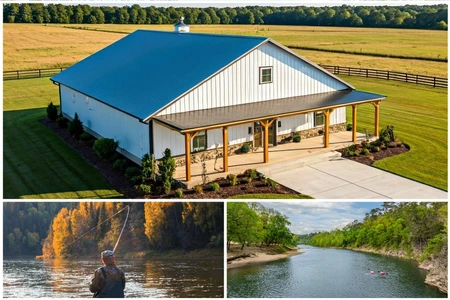
Amherst County - 225 Opus Lane, Amherst, VA
Looking for a vacation home or family getaway? This charming lakefront A-frame is nestled in the foothills of the Blue Ridge Mountains about 40 minutes from popular Lynchburg, Virginia. With 20 acres of forested land, it offers hunting, fishing, or just that perfect solitude you've been thinking of. Owner can finance this property on easy 30-year terms with a 10% down payment.
This home has been newly renovated including new roof and HVAC system, and is sparkling clean ready for move-in. A bedroom on the main level with a full bathroom across the hall offer convenience and rustic charm. The full kitchen has beautiful butcher-block countertops and brand new appliances. As you enter into the great room, you're greeted with astonishing lake views through the soaring chalet windows. A massive masonry fireplace completes the setting for those cozy winter nights in front of the fire.
Upstairs a comfy loft offers still more space for guests or family to spread out. All the finishes are rustic wood that's been newly stained with plenty of natural light. But that's not all! Downstairs is a full walkout basement with yet more room for accommodations. Another cute bathroom downstairs means this is a place you can stay as long as you want without cramping your style.
Finally, the wide deck on the front of the house has the most beautiful view overlooking the lake - your lake! - you've ever seen. It's a deep fishing lake with some granddaddy bass and a little pier on it. All around you are peaceful woods as far as the eye can see. Its time to go ahead and get that vacation place you've been thinking about. Agents are welcome, address is 225 Opus Lane, Amherst VA 24521, price is $400,000, Equal Housing Opportunity.
The home features 2 bedrooms, 2 bathrooms, and a loft overlooking the main living area. The living room includes a full wall of windows with views of the pond, filling the space with natural light and offering a beautiful backdrop year-round. The interior has been recently renovated, and a new roof was just installed.
The full walk-out basement includes a full bathroom and sliding glass doors that open to the backyard and pond are perfect for extra living space, guests, or storage.
This property is part of a quiet lakeside location with three homes and is offered with a shared well and road maintenance agreement. If you're looking for more space, there are up to three cabins available, with the potential to purchase as much as 93 total acres.
Call today to set up a private showing!
Equal Housing Opportunity.


06/02/2025
$3,850,000
562 ac.
ACTIVE
Le Flore County - Pocohontas Rd, Wister, OK
BUZZARD ROOST RESORT
An Exceptional Southeast Oklahoma Retreat: Luxury, Adventure & Natural Beauty
This remarkable property has been transformed into a premier resort-style getaway designed to showcase the breathtaking scenery of Southeast Oklahoma. Set along the north shores of Wister Lake, the estate offers endless opportunities for recreation and relaxation. With two immaculate mini cabins nestled away from the main residence and a private 15-acre lake at your doorstep, this destination is ideal for homesteading, VRBO income, fishing, hunting, hiking, ATV/UTV riding, horseback adventuresyou name it, this place delivers.
LOCATION: Located in LeFlore County, Southeast Oklahoma. Less than 4 hours from DFW, 2 hours from Tulsa, and less than an hour drive from Ft. Smith, Ark.. Approximately 2 miles Southeast of Wister, a rural community with a K-12 school, several retail businesses, 2 livestock sale barns, restaurants, and community services. Less than 700 feet north of the waters of Wister Lake and actually adjoins the Wister Lake Corp land. Numerous other lakes are in the area including Cedar, Kerr, Eufaula, Tenkiller and Broken Bow. The Cedar Lake and Blackfork riding trails are only miles to the south. The Ouachita National Forrest is just miles to the south with all the perks that it provides.
SITE: 562 acres featuring wooded areas, open meadows, and scattered timber. The southern section rises to Buzzard Roost Ridge, offering incredible views of Wister Lake and the surrounding mountain ranges to the north and south. Topography ranges from level to moderately sloping, allowing for exceptional potential homesites, particularly along Buzzard Ridge and the north boundary near Pocahontas Road.
IMPROVEMENTS: The 3,000+ sq ft main residence has been completely remodeled with exceptional craftsmanship and top-tier materials. Features include: 3 bedrooms, 3 bathrooms, Fireplace, Carport, Full-height glass windows overlooking the private lake, A spacious deck capturing panoramic vistas, Two high-end mini cabins sit adjacent to a beautifully crafted rock patio with a fire pitperfect for gatherings or VRBO guests. A large Quonset-style barn provides ample equipment storage. Infrastructure includes: Four gated entrances (two electric), New fencing with painted pipe bracing and corners, A functional chicken coopcomplete with chickens.
ACCESS: Convenient access via county-maintained blacktop frontage on the north side and gravel road on the west. Only 2 miles southwest of Wister and SH-271.
UTILITIES: Electric, rural water, propane, and phone services are available.
USAGE: Perfect for: Homestead VRBO Cabin sites Camping Hunting Hiking ATV/UTV Horseback Riding Recreation
COVER: A blend of hardwoods, pine, scattered openings, and selectively planted pine stands in varying stages of growth. The property features an excellent trail system suitable for UTV/ATV use, horseback riding, or hiking. Strategic thinning has enhanced both aesthetics and usability.
WILDLIFE: Bordering a state-managed wildlife area, the property hosts abundant deer and turkey populations, along with diverse small game. Several feeders and hunting stands are already in place, ensuring exceptional hunting opportunities.
WATER: A stunning 15 acre private lake is the centerpiece of the property, accompanied by two additional pondsone fully groomedsituated in the valley on each end.
COMMENTS: This is truly a rare offering. The improvements are exceptional, the views are unmatched, and the recreational potential is limitless. Surrounded by the Ouachita, Sugarloaf, Cavanal, and East Sans Bois mountain rangeswith a full view of Wister Lake from the southern ridgethis estate captures the essence of Southeast Oklahomas natural beauty.
Whether you're seeking a premier homestead, a high-performing VRBO investment, or the ultimate private retreat, Buzzard Ridge Resort sets a new standard.
Call today to experience it for yourself!


04/14/2025
$159,900
2.25 ac.
ACTIVE
McCurtain County - Broken Bow, OK
New 1,900 sq. ft. Barndo Package* & 2.3 Acre River Access Estate Only $159,900!
Broken Bow Riverfront Closeout Sale!
Minutes to Broken Bow & Hochatown, OK!
One Day Only! Saturday, November 1st!
River Access Estates up to 2+ Acres From $49,900
Riverfronts up to 2+ Acres From $139,900
River Access Barndo Package* 2.25 Acres
with Pond and River Access & A New 1,900 Sq. Ft. Barndo Package* Only $159,900
Call today to reserve your priority appointment at 580-681-0745 and receive a $10,000 coupon toward your purchase during our Broken Bow Riverfront Closeout Sale!
Choose from beautiful, easy to build on riverfront known for excellent fishing and kayaking and just minutes from all the activities in Hochatown and Broken Bow. These beautiful properties are all easy to build riverfronts and river access estates that offer beautiful views and walk to the water riverfronts! All properties enjoy direct river access with our beautiful riverfront park perfect for enjoying the river including an easy kayak launch. Build your dream home or Barndo on these beautiful estates featuring fully complete amenities and infrastructure including excellent roads, underground utilities with water and high-speed internet, and an immaculate gated entrance to protect your investment. Stand out in the competitive rental market in Broken Bow and Hochatown as one of the rare properties to offer riverfront or river access! Getaway from it all in Broken Bow and Hochatown in the Ouachita Mountains of Oklahoma!
Riverstone is just minutes Broken Bow and Hochatown, pristine Broken Bow Lake and beautiful Beaver Bend State Park. Enjoy all the amazing outdoor activities this area has to offer by day and all the family-friendly activities in Houchatown. At night enjoy excellent restaurants, taste great wine or beers at the breweries and wineries or hit the new $238 million casino at Choctaw Landing!
Call today to reserve your priority appointment at 580-681-0745 and receive a $10,000 coupon toward your purchase during our Broken Bow Riverfront Closeout Sale!
These Beautiful Properties feature:
Beautiful Riverstone Landing Park Located on the Riverfront Within Riverstone for all Owners to Enjoy.
Riverstone Landing features a Riverside Beach, a Beautiful Rustic Pavilion with Open-Air Seating with Grills and a Large Outdoor Firepit with Seating to Relax by the Fire.
Recover in One of the Large Hammocks or Swings at Riverstone Landing as You Listen to the Sound of the River.
If You Are Up for Adventure, Take on Our Kayak/Canoe Trail and Enjoy Over a Mile of Riverfront at Riverstone.
Choose From Select Properties Featuring Hammocks, Swings or an Outdoor Firepit!
Youll Know You are Home as You Enter the Immaculate Gated Entrance at Riverstone with Excellent Roads, Underground Utilities Including Water and High Speed Internet Access.
SALE DAY ONLY SPECIALS:
Save $10,000 Off Any Property* When You Reserve a Priority Appointment
Ask Us About Our Zero Down Investment Purchase
One Price System with No Bidding or Escalating Prices
Ask How to Pay No Closing Costs
Excellent Financing Available
Multi-Lot Purchase Discounts
Veteran / Active Military and First Responder Discount
Call today to reserve your priority appointment at 580-681-0745 and receive a $10,000 coupon toward your purchase during our Broken Bow Riverfront Closeout Sale!
*Barndo package consists of land and building materials for the shell of the home. Construction is the buyers' responsibility. Styles and sizes may vary. Home plan may differ from homes shown. Home plans must be approved by the Review Committee before construction. Seller-paid closing costs including prorated taxes and HOA dues on cash purchase closed within 10 days of executed contract. Zero Down Purchase is purchase with IRA or 401k with a deposit to reserve property held in escrow until closing and refunded at closing. $10,000 appointment booking discounts are only valid towards the total purchase price of the lot or lots contracted. No discounts can be applied to advertised properties. Only one of the advertised properties available. Offered by The Woodland Group, LLC, Broker/Owner.


05/13/2025
$9,630,000
428 ac.
ACTIVE
Parker County - 1950 Consolation Drive, Millsap, TX
428.85 Acres on the Brazos River
1950 Consolation Drive, Millsap, Parker Co., Texas 76066
LOCATION: Forty-five miles west of Fort Worth, 17.8 miles west of Weatherford, and 4.4 miles west of Brock in Parker County. Approximately 1,712 feet of Consolation Drive provides excellent paved frontage along with 569 feet of Lazy Bend Road.
TERRAIN: A large, elevated plateau with thick to scattered trees and some open rolling meadows. Sloping terrain with thicker tree cover. 2 river bottom pastures previously sprigged in coastal bermuda with huge pecan trees. Past & present use is agricultural and recreational. 160 feet of elevation change from the river bottom to an elevated plateau presenting beautiful views along with Hicks Bluff. Diverse tree cover including live oak, post oak, elm, mesquite, cedar, pecan, Texas ash, hackberry, red oak, and deer browsing species. Limestone outcrops and some old limestone fences show evidence of long ago. Some prickly pear and yucca plants. Huge limestone boulders with large cracks along the bluff.
WATER: 5,519.97 feet (over a mile) of coveted Brazos River frontage. Two Parker County Water Supply taps. Three stock ponds. One behind the bunkhouse is 25 feet deep and is never
dry. One is shallow and spring fed and have never known to go dry.
IMPROVEMENTS: A large stone pavilion with stone columns, a huge stone wood burning fireplace, a 1-1 bunkhouse with kitchen and shower, and a two-level vaulted metal roof. Stone retaining walls around the pavilion and pipe and cable fencing. A metal building for feed, supplies, and tools. A pipe and cedar stave entry, and wire fencing with cedar staves along Consolation Drive.
WILDLIFE: Deer, turkey, hogs, etc... OUTSTANDING wildlife habitat.
MINERALS: 100% minerals and all royalty except a 10.5 acres royalty & a 9.67 acres royalty out
of 429.6 acres, more or less. One producing gas well.
PROPERTY TAXES: 2024 - $4,692.28 with ag exemption.
COMMENTS: Beautiful property with an excellent location, topography, Brazos River frontage,
diverse tree cover, and big views. Very private and beautiful! It feels much
larger than 428 acres!
EXISTING No mobile homes, no move-in homes, no manufactured homes, no wrecking
RESTRICTIONS: yards, no dump grounds, no surface mining, and no commercial hog, dog,
chicken, goat, or dairy farms allowed.
PRICE: Reduced to $22,500.00 per acre from $25,500.00 per acre. No owner financing or division.
ALL THE INFORMATION CONTAINED HEREON HAS BEEN OBTAINED FROM SOURCES DEEMED RELIABLE. NO REPRESENTATION OR WARRANTIES, EITHER EXPRESSED OR IMPLIED, ARE MADE AS TO ITS ACCURACY BY SAID AGENT. THIS INFORMATION IS SUBJECT TO CHANGES, WITHDRAWAL, ERROR, OMISSION, CORRECTION, OR PRIOR SALE WITHOUT NOTICE. SELLER CAN RECEIVE AND ACCEPT BACKUP CONTRACTS.

11/24/2025
$975,000
205 ac.
ACTIVE
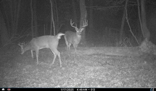
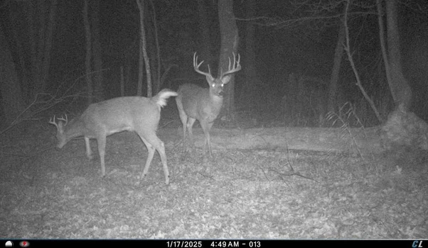
Juneau County - N8510 Fish Road, New Lisbon, WI
If your ideal Wisconsin weekend starts with a thermos of hot coffee and ends around a crackling campfire while swapping stories about the big one that slipped by, this 205-acre hunting property in Juneau County delivers the lifestyle youve been chasing. Set at the end of a quiet dead-end road outside New Lisbon, this recreational escape blends comfort, seclusion, and world-class habitat.
Renovated Hunting Base Camp
The charming 3-bed, 2-bath ranch home has been transformedbrand-new roof, siding, pressure tank, and water heater. Inside, a large, remodeled kitchen with spacious kitchen island opens seamlessly into a cozy living room anchored by a fireplace. Decked out in new LG appliances. The private main-suite offers a quiet end-of-day retreat, and theres plenty of room for hunting buddies, family, and friends. The home was built on a slab with a crawl space, sand-point well, and conventional septicmodern comforts ready for year-round use. Youll find central a/c unit along with a 325-gallon LP tank in the backyard.
The attached 24x24ft two-car garage and multiple backyard pole buildings provide generous storage for tractors, UTVs, implements, stands, and tools. One of the two pole buildings has electric and built on no slab. ae 24x30Whether youre planting plots, hanging cams, or loading up for rifle season, theres space for everything.
A Trophy Whitetail Mecca
The 205 acres have been carefully shaped into exceptional whitetail habitat. Timber stand improvement, diverse hardwoods (including mature oaks), pine groves, lowland bedding thickets, young growth, and high-stem density browse create a landscape deer live innot just pass through.
A comprehensive internal trail system keeps the entire property accessible. More than 10 acres of food plotscorn, clover, brassicas, oats, and moresupplement a 10-acre row-crop lease that provides additional income and forage. Four elevated custom box blinds and multiple treestand setups are already in place. The Farm Service Agency has also approved additional drain tiling options for expanded ag potential.
The Neighborhood Every Hunter Wants
Surrounded by large private parcels and supported by a strong Quality Deer Management community, this area is known for producing Southwest Wisconsinclass trophies. The property checks every whitetail box: food, water, cover, security, and diversity of terrain. Its fully turnkeyjust show up with your gear.
All this sits just minutes from the interstate and under an hour from Madison, making those after-work hunts and spontaneous weekend trips easy. No government programs and taxes are $5,711 annually.
Key Features
205 acres of proven trophy deer habitat with timber diversity, food plots, row-crop acreage, and strategic stand sites.
Fully renovated 3-bed/2-bath ranch camp with new mechanicals, open concept, fireplace, and multiple outbuildings for equipment + gear.
Turnkey hunting property in Juneau County, WI, minutes from I-90/94 and under an hour from Madison.
Contact Joe Nawrot or Brandon Wikman. For more info contact Wisconsin Land Specialist, Joe Nawrot at 608.381.1627 or Brandon Wikman at 608.403.6003
Joe Nawrot and Brandon Wikman are Wisconsins #1 Ranked Listing and Selling Agents of United Country Real Estate working for the Midwests #1 Ranked United Country Real Estate Office.

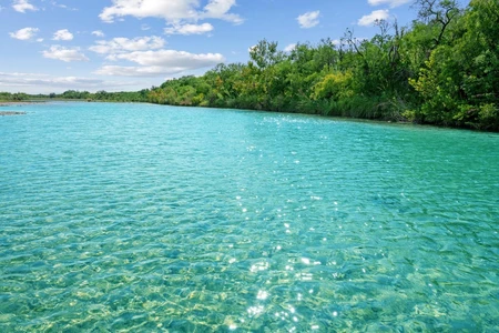

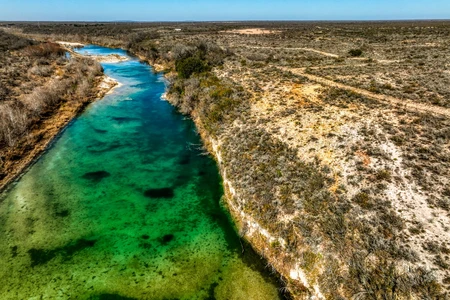
09/10/2025
$19,500,000
7532 ac.
ACTIVE
Uvalde County - Uvalde, TX
Nueces River Ranch: A Texas Oasis and Generational Legacy
Welcome to Nueces River Ranch, an unparalleled 7,530 acre estate that embodies the wild, untamed spirit of the Edwards Plateau. With approximately half a mile of private Nueces River frontage, this expansive property is a rare finda legacy-sized parcel offering exceptional privacy, boundless adventure, and an opportunity to create a generational family retreat. Conveniently situated just 20 miles from both the modern amenities of Uvalde and the rustic charm of Camp Wood, this ranch is your exclusive gateway to the heart of Texas. ******Motivated seller, offering 4.5% commission to the buyers agent! *******
Crystal Clear Waters and Natural Beauty
Water is a defining feature of this magnificent property. The crystal-clear Nueces River forms a portion of the western boundary, providing a tranquil and secluded retreat. The river's deep, blue-tinted channel is ideal for swimming, fishing, and kayaking. Anglers can expect to find native Guadalupe bass, largemouth bass, sunfish, and catfish. In addition to the river, the ranch has two reliable water wells that feed multiple watering holes, serving both wildlife and livestock. The propertys rich vegetationincluding majestic live oaks, mesquite, and sycamore treesenhances its scenic beauty. In the spring, the land transforms into a vibrant mosaic of wildflowers, including Texas bluebonnets, creating a stunning backdrop for outdoor activities.
Unrivaled Terrain and Panoramic Vistas
Spanning approximately five miles by five miles, the ranch features a diverse topography that transitions from rolling plateaus to rugged canyons carved by wet-weather creeks. Elevations climb from 1,160 feet to a breathtaking 1,664 feet on the highest plateau. This majestic summit offers sweeping 360-degree views of the surrounding Sycamore Mountain Range and the stunning landscape below. A network of well-maintained roads and UTV trails ensures easy access across the property, allowing you to explore every corner of this vast wilderness.
Ranch Improvements
Nueces River Ranch offers substantial existing improvements that enhance management and provide a foundation for immediate use. Water infrastructure is a key asset, with three reliable water wells one solar and one electric feeding an extensive network of buried water lines. These lines are supplied by three cisterns that provide water to multiple troughs strategically placed throughout the property for both wildlife and livestock. Electricity has been run well into the property, providing a critical utility for any future building. The ranch's accessibility is excellent, thanks to its great main roads and many miles of UTV trails that provide unparalleled access across the rugged terrain. The property is also secured by perimeter barbed wire fencing, ensuring clear boundaries. For the avid hunter, numerous tower hunting stands and feeders are already in place and will convey with the sale, making the ranch a true turnkey operation.
A True Hunter's Paradise
Nueces River Ranch is a premier hunting destination. The diverse terrain and rich native vegetation support a thriving population of both native and free-range exotic species. The ranch is home to a robust population of white-tailed deer, with the region consistently ranked among the top in the state. Hunters will also find Rio Grande turkey, blue quail, and dove, along with free-range axis deer, sable antelope, and aoudad that roam the landscape. Strategically placed elevated hunting blinds, feeders, and water troughs will convey with the sale, making this a turnkey hunting operation.
Native Plants and Grasses
The ranch supports a rich and diverse tapestry of native Texas vegetation, which enhances both its scenic beauty and ecological value. Majestic live oaks, Texas red oaks, and mesquite trees are found throughout the property, providing shade and visual appeal. Denser stands of sycamore trees flourish along the Nueces River and within the rugged canyons, marking the pathways of water and creating a lush, cool environment. The native brush species, including cenizo, prickly pear cactus, blackbrush acacia, and guajillo, provide essential cover and browse for the ranchs thriving wildlife population. In spring, the landscape transforms into a breathtaking mosaic of wildflowers, with vibrant patches of bluebonnets, Engelmann daisies, and Maximilian sunflowers complemented by native grasses like Indian blanket and prairie verbena that attract pollinators and enrich the land's biodiversity. This robust vegetation is not only a visual delight but is also fundamental to the health of the entire ecosystem, supporting the ranch's abundant game and livestock.
A Legacy Property for Generations to Come
Nueces River Ranch is far more than a simple acquisition; it is a true legacy propertya profound commitment to the future. This immense and untouched piece of the Texas Hill Country offers a rare opportunity to secure a sanctuary where a family can escape the modern world and establish a permanent, shared foundation. It is a place to pass down not just a name or an inheritance, but a way of life rooted in the timeless values of stewardship, conservation, and a deep appreciation for nature. In its vast acreage and unparalleled natural resources, the ranch provides an unwavering anchor in a changing world, promising to be a cherished source of enduring memories and a living testament to a family's heritage for generations to come.
Nearby Attractions
Garner State Park: Just a short drive away, this iconic state park is famous for its crystal-clear Frio River, making it a prime destination for swimming, tubing, and hiking. Its stunning scenic beauty and family-friendly atmosphere draw visitors from all over the state.
Lost Maples State Natural Area: Known for its breathtaking fall foliage, this natural area offers some of the best hiking and birding opportunities in Texas. The rugged trails and unique plant life make it a favorite for nature enthusiasts.
Nueces River Canyon: The ranch is located within this scenic region, known for its picturesque drives and dramatic landscape. The surrounding area is popular for kayaking, fishing, and simply enjoying the rugged beauty of the Hill Country.
Local Towns: The towns of Uvalde (20 miles south) and Camp Wood (20 miles north) provide a balance of amenities and local charm. Uvalde is home to grocery stores, restaurants, and the Garner Field Airport, while Camp Wood offers a quiet, small-town atmosphere with local cafes and shops.
Location and Accessibility
San Antonio: 100 miles
Del Rio: 61 miles
Austin: 192 miles
Houston: 295 miles
Fort Worth: 344 miles
Midland: 260 miles
Nearby Airports
Garner Field (UVA): 20 miles
Del Rio International Airport (DRT): 60 miles
San Antonio International Airport (SAT): 100 miles
Top Attributes:
Immense Acreage: Spanning an unparalleled 7,530 acres, the ranch offers a level of privacy, scale, and exclusivity that is truly rare.
Private River Frontage: The ranch features approximately half a mile of private frontage on the crystal-clear Nueces River, providing a unique and highly desirable recreational asset.
Legacy Property: This is more than land; it is a generational asset, a sanctuary where a family can build a lasting legacy and pass down a heritage of stewardship.
World-Class Hunting: The property is a premier hunting destination for both native species like white-tailed deer and free-range exotics including axis deer, sable antelope, and aoudad.
Unrivaled Terrain: The diverse topography includes dramatic canyons and a high plateau offering sweeping 360-degree views of the surrounding landscape.
Abundant Water Sources: In addition to the river, the ranch has two reliable water wells and multiple water troughs that serve both wildlife and livestock.
Excellent Accessibility: A vast network of well-maintained roads and UTV trails ensures easy access to every corner of the immense property.
Rich Native Vegetation: The land supports a wide variety of native plants, including majestic live oaks, mesquite, and a vibrant display of wildflowers in the spring.
Secluded Location: Situated along a state highway between two towns, the ranch offers the ideal balance of deep privacy and convenient access to amenities.
Turnkey Hunting Operation: The sale includes strategically placed elevated hunting blinds, feeders, and water troughs, making the ranch ready for immediate use.
All information in this advertisement & herein is considered reliable but not guaranteed. Buyer to verify all information in MLS, marketing or website including but not limited to schools, square footage, acres, taxes, easements & minerals.

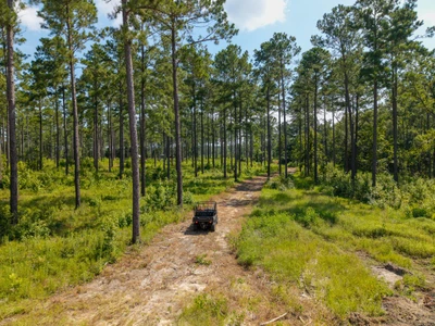

08/12/2025
$1,140,338
196.61 ac.
ACTIVE
Tattnall County - 0 Henry Moxley Road, Cobbtown, GA
Moxley Farm 197 Acres | Tattnall County, Georgia
Property Overview
Moxley Farm is a rare opportunity to own 197 acres of prime recreational land in Tattnall County, Georgia. This exceptional property combines well-managed timber stands, diverse wildlife habitat, year-round water, and convenient access making it an ideal investment for hunters, outdoor enthusiasts, and timberland investors alike. With established power and water, multiple gated entrances, and outstanding aesthetics, Moxley Farm is truly turn-key.
_______________________________________________________________________________________________
Timber Resource
For generations, the owners of Moxley Farm have carefully managed the timber to maintain a healthy forest, enhance wildlife habitat, and preserve its visual appeal. Periodic thinnings and prescribed burns have produced vigorous stands with strong growth potential and high value.
- 2007 Planted Longleaf Pine: 28.8 acres approaching its first thinning, offering near-term income potential.
- Mature Loblolly Pine Plantation: 119.8 acres groomed for quality sawtimber. Ready for immediate harvest if desired, with excellent reforestation potential.
- Hardwood Stands: Approximately 34 acres of upland and bottomland hardwoods along Beaver Creek, adding diversity, nutrition, and water-quality protection.
________________________________________
Wildlife & Habitat
Moxley Farm proves that top-tier timber management can go hand-in-hand with exceptional wildlife habitat.
- Deer & Turkey: The mix of mature pines, hardwoods, creek bottoms, and strategically placed food plots creates a paradise for whitetail and turkey hunters.
- Creek & Corridors: Beaver Creek and its tributaries provide natural travel corridors, water sources, and habitat diversity.
- Transmission Line Right-of-Way: 8 acres of open corridor offer long-range shooting opportunities and additional food plot potential.
- Understory Growth: Thinned loblolly stands allow sunlight to fuel a lush understory, improving browse and cover.
________________________________________
Improvements
The property includes a 1-acre campsite with water and power already in place. Designed for two campers, the site can easily accommodate more RVs, mobile homes, or additional structures. Underground power is available along Henry Moxley Road.
________________________________________
Water Features
Beaver Creek: A perennial stream running north to south, providing year-round water and excellent habitat.
Three Seasonal Tributaries Additional wildlife value and water diversity.
________________________________________
Soils & Topography
A diverse mix of upland, moderately sloped, and low-lying soils supports both timber production and wildlife habitat.
- High Site Index: Excellent potential for loblolly pine growth.
- Terrain: Gently level to gently sloping (05%), with elevations from 180 at the campsite to 160 along Beaver Creek.
________________________________________
Access
- Road Frontage: 5,200 feet along Henry Moxley Road (1,150 paved, remainder maintained dirt road) plus 1,100 feet along County Road 99.
- Four Gated Entrances: Two on each road, allowing easy access to all areas of the property.
- Convenient Location: Only five minutes from I-16, providing quick access to nearby cities.
Approximate Travel Times:
- Statesboro 35 minutes
- Macon 1 hr 30 min
- Savannah 1 hr 10 min
- Atlanta 2 hrs 45 min
- Jacksonville 2 hrs 40 min
- Orlando 4 hrs 45 min
________________________________________
Summary
Moxley Farm is a premier recreational and timberland tract offering a blend of investment-grade timber, outstanding wildlife habitat, and turn-key hunting amenities. With established utilities, multiple gated entrances, and excellent access to major cities, it's ready for years of outdoor enjoyment and long-term growth.


11/23/2025
$9,777
0.22 ac.
ACTIVE
Putnam County - Interlachen, FL
Want a gift that changes everything? Try your own piece of peaceful Florida land. With power on site, flexible zoning, and nearby outdoor fun, this Putnam County lot gives you the perfect mix of freedom, escape, and possibility.
OWNER FINANCING: $377 down payment + One-time/non-refundable $249 doc fee, then $177/Month for 68 Months
Own your piece of Florida with this 0.22-acre parcel in serene Putnam County- a perfect spot for retirees, investors, and anyone looking for a peaceful escape. Whether you're dreaming of a quiet retirement retreat, a future home, or a smart land investment, this lot offers incredible flexibility and opportunity.
For Retirees: Enjoy mornings surrounded by nature, afternoons exploring nearby parks, trails, and rivers, and evenings unwinding in your private sanctuary. With low taxes, no HOA fees, and flexible zoning, this lot gives you the freedom to build your dream retirement home, create a beautiful garden, or simply relax in a quiet, safe, and friendly community.
For Investors: This property is a smart, low-maintenance investment. Flexible zoning and growing demand in Putnam County make it ideal to hold for long-term appreciation. Easy dirt road access and nearby power add to the property's convenience, while the absence of HOA fees and low taxes ensure financial peace of mind.
For Lifestyle & Recreation: Explore nearby Ravine Gardens State Park, the scenic St. Johns River, Crescent Lake, and countless hiking and nature trails. Whether you love bird watching, peaceful strolls, or immersing yourself in Florida's great outdoors, this lot offers endless ways to enjoy nature while still being close to towns and modern amenities.
Convenient Location: Interlachen is just 9 miles away, Palatka 21 miles, and Gainesville 36 miles, giving you easy access to shopping, dining, and entertainment while maintaining your private retreat.
Quick Highlights:
- Lot Size: 0.22 acres in peaceful Putnam County, FL
- Access & Utilities: Easy dirt road access
- Power lines are already in place along the same street as the property
- Financial Benefits: No HOA, low taxes, flexible zoning
- Lifestyle Opportunities: Ideal for a retirement home, garden oasis, or private retreat
- Nature & Serenity: Peaceful surroundings with year-round outdoor enjoyment
Whether you're seeking a peaceful escape, a retirement haven, or a smart investment, this Putnam County property delivers all three. Build your future, enjoy your present, and secure your piece of Florida today!
Here at Lifetime Land USA we pride ourselves in making sure the process is simple, quick and stress-free for you! We also offer easy financing as well as a discounted cash price.
To learn more about us and to view our other listings visit our website today!
PROPERTY DETAILS
APN: 24-09-24-4075-0460-0270
Size: 0.22
County, State: Putnam County Florida
Closest Town: 7 miles to Interlachen. 20 miles to Palatka. 35 miles to Gainesville. 1.5 hrs drive to Jacksonville. 1 hr & 15 mins drive to St. Augustine Beach. 2 hrs drive to Orlando.
Closest Shopping: 5 miles to gas station. 8 miles to grocery store. 7 miles to hardware store. 17 miles to Walmart.
HOA: No HOA
Highlights: Set in a peaceful and steadily growing neighborhood, this property features great dirt road access directly from Usina Ave. Power lines are already in place along the same street as the property, giving you a strong head start on your next project. A fantastic opportunity in a quiet, well-established area.
Utility Options
Power: Power lines at street. Contact the local power provider for availability.
Water: Contact the local water provider for availability. If water is not available, a water well would be required.
Septic: Septic system would be required.
Additional Zoning Notes
Camping/RV: Allowed and should not exceed 14 consecutive days or 120 non-consecutive days a year.
Mobile Homes: Allowed
Custom Homes: There is NO time limit to build. No minimum sq.ft for a Modular Home.
Get in touch with one of our representatives today by visiting our website or reaching us by phone/email so we can help you find your perfect fit!


07/22/2025
$63,618,090
10692 ac.
ACTIVE
Zavala County - La Pryor, TX
As a result, North Ranch is home to exceptional white-tailed deer and some of the best bird huntingBobwhite quail, dove and Rio Grande turkeysin the state. While the deer have been managed under an MLDP-3 since 2017, the hunting has been limited to the owner's family, friends and invited business associates. Mature whitetails measuring 160" 190" have been harvested over the past three years. In addition, the ranch boasts oryx, axis deer and feral hogs as well as a host of non-game species.
The Land and the Water
The deep, rich blackland found in the river bottom transitions into strong red clay which gives way to sandy loam. Towering pecans, Mexican sycamore and oaks stand sentry along the river, while guajillo, black brush, white brush, mesquite, guayacan and other protein-rich brush species provide food and shelter for wildlife in the uplands.
As part of the brush management plan, the land has been strategically cleared to increase edge preferred by wildlife and strategically roller chopped to increase the diversity of grasses and forbs that are essential to upland birds. Native grasses have been replanted on suitable sites.
The Nueces runs clear and turquoise-hued through the ranch. The river is pocked with deep, blue holes that hold water and allow for swimming and fishing even in the dry years. The North Ranch possesses water rights from the Nueces.
In addition to the river, the North Ranch has approximately 1.5 miles of surface water that measures about one-quarter mile wide. The surface water catchment is a collection of various creeks and ponds that is fed by runoff and irrigation water.
To ensure that water is easily accessible in all quadrants of the ranch, more than 7.5 miles of 2-inch poly water line and an additional 7.5 miles of 4-inch poly water line have been laid and buried. The water distribution system also includes eight cement water troughs that are 8-feet in diameter encircled by 8-foot cement skirts and two cement water troughs, 20-feet in diameter with 8-foot cement skirts.
There are four irrigation wells (one = 120 gal./min.; one = 300 gal./min.; two = 110 gal./min.) The irrigation wells are used, in part, to supply a 40-acre Reinke pivot and a 36-acre Reinke pivot. The pivots water food plots that have traditionally been planted in sunflowers to enhance dove hunting.
To meet domestic water needs, the ranch has two solar wells, six electric submersible wells and another well (60 gal./min.) connected to a 60,000-gallon storage tank that supplies the headquarters compound.
The Living
Thanks to the attention to detail, living is comfortable and easy. The style, as befitting a Brush Country ranch, is rustically elegant.
Working in a style reminiscent of Mexico and the Southwest, artisans combined adobe, stone, hammered metal and wood to create spaces that are inviting, warm and reflective of the region's history, culture and lifestyle. Strategically placed courtyards and gathering areas ensure that family and guests can spend their days and nights soaking up the peace, quiet and textured beauty of South Texas.
The two-bedroom/two-bath Farm House encompasses 1,600 square feet of updated, beautifully appointed living space. Currently used as the owners' home, the open floor plan residence features a kitchen with an eating area and living room.
With four bedrooms and four baths, the 2,500 square foot Dog Trot, situated across the courtyard from the Farm House, serves as a guest house. As the name implies, its architectural design reflects the dog trot cabins favored by early Texas pioneers.
The two-story Chef House, which currently serves as lodging for visiting chefs, features two bedrooms, one full bath and one half bath.
Set away from the main compound, the Cowboy Cabins measure about 1,000 square feet. The lodge, built in a u-shape around a central courtyard, features six bedrooms each with a private bath.
The River House sits near the Nueces. It's currently used as a place to store fishing rods, inner tubes and other gear for water fun, but it could be updated and upgraded to living quarters.
Arguably, the ranch's focal point is the 11,600 square foot Barndominium. The front one-third has been finished as functionally beautiful living space, while the remaining two-thirds is used as storage for hunting vehicles and other equipment.
The living space includes a top-of-the-line commercial kitchen with an attached utility area, a dining area, living room and bathroom. In addition, the Barndominium has four bedrooms each with a private bath. The bedrooms are accessed by a split staircase that is easily reached from the barndo's storage area. This practical configuration allows hunters to wash off the evidence of the day's excursion without passing through the rest of the living space.
In addition to the residences, the North Ranch has a 700 square foot high-capacity laundry and a 500 square foot secure, self-contained gun room.
The Infrastructure
To ensure that both rifle shooters and shotgunners are in top form, the North Ranch has a shooting range and a skeet range. The shooting range, which has a two-story, covered shooting deck, extends 700 yards, with targets at 100, 200, 300, 400, 500 and 700 yards. The skeet range features five stations and an elevated shooting pavilion.
The North Ranch's perimeter is high-fenced and there is also a 3,000 acre high-fenced "enclosure" within the ranch that holds the oryx herd and some axis. In recent years, approximately 7 miles of five-wire cedar post fences have been installed as cross fences.
While the ranch hasn't been grazed in the past three years, it is outfitted to handle cattle with a functional set of working pens. The ranch roads provide easy access to the entire ranch.
In addition to the storage space within the barndominium, there are two equipment barns. One is 2,000 square feet and the other is 4,000 square feet
All furnishings and the 29 Atascosa deer blinds, 31 Atascosa 500-pound corn feeders and 32 2,000-lb. protein feeders convey with the sale.
The Opportunity
For anyone looking for the ultimate recreation destination, the North Ranch has it all. Abundant water. Exceptional habitat. Plentiful wildlife. Well-designed lodging. New infrastructure. And each piece is already in place, so you can begin to enjoy one of the premier hunting and recreation ranches in the country immediately.
Seize this rare opportunity before it disappears as quickly as a wily muy grande into the brush. . .
Existing hunting and grazing leases create an income-producing opportunity for a new owner, if desired.
.
To experience the opportunity of the North Ranch for yourself, call Howard W. Hood at (830) 739-3815 with Hood Real Estate, Inc. The ranch is listed for $5,950/acre.


03/10/2025
$23,500,000
3173 ac.
ACTIVE
Callahan County - 7985 FM 2228, Baird, TX
PROPERTY DESCRIPTION: Nestled among the high hilltops of the Callahan Divide, Spring Mesa Ranch is a true legacy property, offering breathtaking landscapes, first-class accommodations, and a rich frontier history. Named after the mountain peak that rises 2,182 feet within its borders, this ranch has been meticulously restored to reflect the look and feel of a Texas cattle ranch from the 1840s. A large-scale cedar removal and native grass restoration program has brought the owner's vision to life, creating some of the most scenic and productive wildlife habitats and rangelands in the region.
The land features 38 earthen stock tanks, the headwaters of Brushy and Cottonwood Creeks, seven miles of all-weather caliche roads, excellent fencing and cross-fencing, cattle pens, and nine pastures. Atop the hills, a skeet shooting pavilion and a sanctuary with a prominent cross offer breathtaking views. Upon entering through the main gate, a private all-weather rock road winds through the foothills, revealing the magnificent hilltop residencean 8-bedroom, 8-bathroom home with 10,401 square feet of indoor living space, a swimming pool and outdoor entertainment area, all built with no expense spared.
East of the headquarters, the hill country style Happy House' sits in a majestic oak-covered setting, providing a serene retreat. Located on FM 2228, a ranch employee's manufactured home sits in a nice grove of oak trees. Both homes are in very good condition. Additional improvements include a 100' x 45' eight-stall horse barn with an office and a 60' x 60' shop with an apartment.
Once part of the historic 50,000-acre Cross Bar Ranch, Spring Mesa Ranch stands as a testament to vision, conservation, and Texas heritage. With its unparalleled natural beauty, modern amenities, and historical significance, this extraordinary property offers a rare opportunity for ranching, recreation, and the creation of a lasting family legacy.
LOCATION: Spring Mesa Ranch is located on the western edge of the Cross Timbers & Prairies Region of Texas, south of Interstate 20, between Putnam and Baird in east-central Callahan County, near the historic community of Admiral. It is approximately 2 hours and 30 minutes from Dallas and 2 hours from Fort Worth. Nearby towns include Cross Plains (12 miles south), Baird (16 miles northwest), Cisco (25 miles northeast), Abilene (37 miles northwest), and Midland (186 miles west).
Physical Address: 7985 FM-2228, Baird, Texas 79504
DIRECTIONS: From Dallas and Fort Worth, take I-20 west for approximately 120 miles to Putnam, Texas. Just past Putnam, take Exit 313 to FM-2228 and turn left onto FM-2228. Travel south for approximately 11 miles to the ranch entrance on the right.
ACCESS & ROADS: Ranch has 2 miles of FM 2228 frontage and access by a roadway easement off CR461 (no roadway easements run through Spring Mesa). The property features 7 miles of interior all-weather caliche roads in excellent condition. The main home one-half mile from the entrance and is surrounded by a hog-proof fence. Both perimeter and interior fencing are in excellent condition, with interior cattle guards allowing easy travel throughout the ranch. Two gravel pits provide a convenient source of road base for maintenance.
HISTORY: The current ownership acquired 441+/- acres in 2004, followed by additional land acquisitions, forming Spring Mesa #1 (the northern half of the ranch). Years later, an additional 1,587+/- acres were added, creating the southern half of the now 3,173+/- acre Spring Mesa Ranch. The land was originally heavily wooded with cedar, and native grasses were in poor condition. Under the vision of Texas oil and gas pioneer Dick Lowe and Dr. John Merrill, former head of TCU's Ranch Management program, the ranch underwent a careful transformation to restore and revitalize the ecosystem. Restoration efforts began with the end goal of taking this ranch back to the 1800s. Through meticulous land management, invasive cedar trees were removed, revealing hidden springs, native grasses and hardwoods.
Once part of the vast 50,000-acre Cross Bar Ranch, Spring Mesa Ranch is steeped in history, with reminders of the past still scattered across the ranch. Notable historical features include:
Harper House Remnants: Built by a family who purchased land in the 1890s. The original fireplace, chimney, and cistern remain.
Old String Town Site: The original Cross Bar Ranch owner, Mr. Cordwendt, built 14 houses for his hired help. Though little remains, the old swimming hole/pond still exists.
Cordwendt's Hand-Dug Water Well: A well dug by Mr. Cordwendt during his ownership.
Hester Twins Gravesite (1895): The burial site of two young girls who succumbed to typhus while traveling by wagon.
MAIN HOUSE: The primary residence is a Texas Hill Country-style masterpiece, originally built in 2005 as a family retreat. It underwent significant additions in 2008 and 2010, expanding into a 16,770+/- square-foot compound with 10,401 square feet of HVAC-controlled interior space and 6,369 square feet of outdoor patio and entertainment area. Designed by David Lewis Builders, the home is ideal for entertaining and relaxation.
The 8 bedroom/ 8 bathroom residence consists of three interconnected buildings under the same roof being further described as:
East Building (2005): Features three bedrooms, three bathrooms, a full-size kitchen, a walk-in gun safe, a pool table, and an open living room with wood-burning fireplace. The upstairs includes a children's bunkroom, full bathroom, and loft-style living room.
Middle Building (2008): Houses two guest bedrooms with full bathrooms, two half baths, a large kitchen with an island, an impressive fireplace centerpiece open on four sides, and two open living/ entertainment areas. A crow's nest at the top provides 360-degree views. Outdoor amenities include a swimming pool, outdoor kitchen, propane fire pit, and a golf driving range.
West Building (2010): Serves as the master suite, featuring three bedrooms, three bathrooms, his-and-her full baths, large closets, a living area with a fireplace, a downstairs gun safe room, a sauna, and an outdoor elevator/lift.
The home water system is supplied by three wells with two buildings housing four large holding tanks and two top-tier reverse osmosis (RO) systems. There is also a 60,000 gallon in-ground cistern providing an additional source of water. Six generators provide backup power for the home. THE HAPPY HOUSE: Renovated in 2013 and a short drive from the main home, this two-story house features four bedrooms, three bathrooms, two porches, a balcony, and a wood-burning fireplaceall surrounded by mature oak trees. Nestled in a private and tranquil setting, the home is ideal for guests or a ranch manager and their family.
Combined with the main house, the property offers a total of 12 bedrooms, comfortably accommodating 25 guests. HOME FURNISHINGS: The main house and guest house are sold fully furnished, excluding select personal items. The furniture is high quality, appliances are top of the line and this property is ready to use day one.
EQUIPMENT: In order to keep the property operational, the owner is including the following items:
2010 F250 King Ranch flatbed 4x4 truck
Case backhoe
1984 Freightliner dump truck
John Deere Z930A & Z930M zero turn mowers
24' Galyean Gooseneck cattle trailer
16' HD utility trailer (black) & 16' utility trailer (green)
Protein feed trailer with delivery system
Bobcat T740 skid steer plus attachments
Bobcat E88 excavator plus attachments
TC33D New Holland small tractor
Mini van UTV
2021 Polaris Ranger 1000
12' four-wheeler trailer
BARN: Built in 2017, this 100' x 45' horse barn features eight stalls, a wash bay with hot water, a manager's office, and a tack room. The manager's office is equipped with central heat, air conditioning, and internet service. A round pen, conveniently located adjacent to the barn, provides an ideal space for horse training.
SHOP: Built in 2005, this 60' x 60' structure includes a spacious workshop, indoor/outdoor equipment storage, a one-bedroom apartment with a loft, a walk-in game cooler and 20,000 gallon in-ground cistern. Just behind the shop, a dedicated shooting range offers a great setup for both pistols and rifles. CATTLE PENS & CATTLE FENCING: The ranch is fully fenced and cross-fenced for cattle with two sets of steel cattle pens. Both perimeter and cross fencing are in excellent condition, with cattle guards allowing for easy travel between the nine primary pastures.
SKEET SHOOTING PAVILION: With stunning views, this pavilion is perfect for skeet shooting and/ or cooking out. The area is fenced separately and includes a covered grilling & picnic space. THE CROSS & REFLECTION AREA: Erected in 2014, a monumental cross sits on a high ridge, surrounded by stone seats engraved with the names of the disciples. Offering breathtaking views of the valley below, this area was designed for quiet reflection and prayer. SURFACE WATER: Spring Mesa Ranch boasts abundant water resources, including 38 earthen stock ponds, 15 of which are spring-fed and stocked with fish. The stock ponds provide excellent water sources for cattle and wildlife while offering opportunities for fishing and waterfowl hunting.
WATER WELLS: The ranch is equipped with twelve (12) water wells, ensuring reliable water access across the property. Average well depth is between 100-200 feet producing 3-12 gallons per minute. In total, the ranch features five (5) electric wells and seven (7) solar wells, creating a robust and sustainable water infrastructure.
At the main house, three (3) wells supply water to four (4) large holding tankstwo with 10,000-gallon capacities and two with 3,000-gallon capacities. Water from these tanks is filtered through a reverse osmosis (RO) system to ensure high-quality drinking water. Water tanks and equipment are hous


07/25/2024
$4,150,000
1280 ac.
ACTIVE
Sweet Grass County - Big Timber, MT
The Stagecoach Trail Ranch was once a corridor in the old west providing passage to travelers from Billings to Bozeman. Today this hunters paradise also serves as a major corridor for wildlife between two large land holdings that harbor herds of Elk, Mule Deer and Antelope. Not only does it offer the aforementioned species but, also, it offers black bear, turkey, upland birds, and mountain lion.
The two parcel property consists of 1,280 +/- acres in total. Of this contiguous two section ranch, there is 160+/- acres of dryland hay acreage with the remainder being lightly timbered filled draws and hills. The property gains elevation from east to west with spring fed tributaries carving out draws to the center of the property where the stagecoach trail was once located.
The old stagecoach trail is now part of the county road where the two seasonal tributaries flow towards until meeting the Deadmans Creek that flows west to east throughout the main property.
In its current capacity it is a working ranch maintaining a balance of smaller ruminants and cattle. The headquarters of the ranch features the main 16x80 3B/2B modular home on a foundation, homestead, barn, 7 additional outbuildings, and corrals. Additionally, there is 2023 16x80 3B/2B modular home on a foundation at the eastern border of the property.


10/18/2025
$7,995
0.22 ac.
ACTIVE
Putnam County - 0 Schaffer Street, Interlachen, FL
*** 5-Day Become A Landowner Challenge: Start For Just $1 Down ***
Over 600 people have already done this, will you be next?
Here's the plan:
Day 1: Book Your Free Meeting to Unlock Exclusive Offers
- Let's explore your land options together and unlock exclusive offers you won't find online. Go to: book.gokcap. com
Day 2: Place the Property on Hold
- Hold your property on our website so no one else can grab it, you're officially on the path to becoming a landowner.
Day 3: Explore Your Land
- Step onto your land, even virtually, do your homework, and imagine how you'll make it your own.
Day 4: Pick Your Path
- Choose the payment plan that's right for you, with 5% cash back rewards, 9 free bonuses, and a 365-Day Land Exchange Guarantee to keep you safe.
Day 5: Celebrate Ownership
- Sign your agreement and join the community of 600+ proud landowners.
WHAT YOU'LL LOVE ABOUT THIS LAND
Are you looking for a peaceful place to build your home or invest for the future?
This 0.22-acre corner lot in Putnam County, Florida could be exactly what you've been searching for.
- Hold it now for just $50 on our website. Freedom Friday coupon available on our website.
Located just off a dirt road, this property gives you space to breathe without feeling isolated.
Picture a small cabin or mobile home tucked among the pine flatwoods where you can listen to the breeze rustle through the trees.
The land is mostly level, with a gentle 0-5% slope, a mix of pine and grass vegetation, and it's not in a special hazard flood zone.
Zoned R-2 Residential, this lot offers flexibility that's hard to find.
You can build a single-family home, place a mobile home, or use it for recreational purposes.
And since there's no HOA, you won't have to worry about extra fees or restrictive rules.
Utilities are still being developed in the area, but there are homes nearby, meaning power is accessible.
But why Putnam County?
Affordable land prices, low property taxes, and its central Florida location make it a hidden gem for investors and families alike.
The area is seeing renewed interest thanks to growing nearby cities like Palatka and Interlachen, where new housing, retail, and infrastructure projects are helping drive future property values.
So if you've been waiting for the right place to build or invest, now's the time.
This corner lot could make a great first investment or future homesite as the region expands.
Note: All information provided is based on our own research. We always recommend confirming details like zoning, access, and utilities directly with Putnam County before building or making plans.
LOT BREAKDOWN: WHAT YOU'RE GETTING
Assessor's Parcel Number: 25-09-24-4075-0840-0180
Legal Description: Interlachen Lakes Estates Frederick Town Unit 16 Mb5 P4 Blk 84 Lot 18
Elevation: 165
GPS Center Coordinates (Approx.): 29.67793, -81.84741
Annual Taxes: ~$87.91
Zoning: Residential-2 (R-2)
Time Limit To Build: None as far as we are aware
Access: Dirt Road
Power: We recommend that you contact Putnam County to confirm
Water: A well would need to be installed
Sewer: A septic system would need to be installed
Official Contacts: Please contact Putnam County
RVs Allowed? We recommend that you contact Putnam County to confirm, but according to our research, you can get a temporary permit to live in an RV while building a home
Buildable? Because we do not know the specifics of what you may want to build on the property, we recommend that you contact the building and/or zoning department(s) for more information on the relevant zoning and building regulations and how to obtain a building permit
Survey Available? No, we have not had a survey commissioned, but if you would like to pay for a survey we would be happy to work with your chosen surveyor
In HOA? No HOA
Annual HOA Dues: ~$0.00
I'VE HELPED OVER 600 PEOPLE ACROSS THE COUNTRY BECOME LANDOWNERS AND LIVE THEIR VERSION OF THE AMERICAN DREAM
You deserve to own land and live free.
If you've been priced out, stuck renting, or confused by the land-buying process, I'm here to change that.
But most buyers don't miss out because they chose the wrong lot, they miss out because they waited too long.
That's why we offer a $50 hold for 2 days, so you can secure the property while you decide if it's the right fit.
And if you're wondering what happens next, here's our Buy With Confidence Promise:
Real people to talk to, whenever you need
365-day exchange guarantee on owner-financed land
Full support before, during, and after the sale
Plus: Every purchase includes 9 free bonuses, like a 3-night vacation voucher, monthly Q&A calls with Erika (our co-founder), and a 30-minute architectural consult, nearly $3,000 in real-world tools to help you get started fast and spend less doing it.


07/03/2025
$8,975,000
489 ac.
ACTIVE
Monroe County - 00 Highway 70, Biscoe, AR
Properties along the Cache River have been very few and far between for many years and this offering is not a random piece that will leave you wondering if mallards will come through the trees the way you have always dreamed. This 489.48 surveyed acre tract is located off of Highway 70 just West of Brinkley in the absolute center of the Arkansas waterfowl flyway. There is a 50' easement that leads you to a gravel parking lot at the NW corner where you can launch a boat using the existing gravel launch and boat ditch or take off on a side by side utilizing the improved road system. It is already setup with 3 wells (2 electric and 1 turbine) along with all the infrastucture needed to flood the woods and fields. The amount of work/improvements the landowner has completed Summer 2025 is impressive:
Boat ditches mopped out
Interior roads cleaned, exterior roads mowed
New primary road being finished up to provide access outside the timber instead of through it
Small portions of the field being cut to grade to make duck food plots more efficient to drain and plant next Spring, while maintaining natural swags
All water control structures and beaver guards cleaned out
Electric wells checked and ready
New electric service established at the parking lot for a future cabin site, barn, etc.
It is not often that I have been able to hunt the tracts I am selling, but this is one very fortunate case where I know how good the hunting is because I have lived "the good ol days" on this property in years past. I will never forget the first time I was on it and flushed a huge raft of mallards on the southern end of the timber thinking "well that was cool, but there they all went" just for the same thing to happen two more times on the same visit. We were riding a UTV through the woods watching them circle back and then fade off working back to the South as we unknowingly continued on to the other two rafts towards the North.
One very unique thing about this tract is ideal terrain. While you may not be able to flood boundary to boundary by pump, the benefits are two-fold. Number one, the slight ridges provide just enough elevation where red oak timber that produces acorns a duck can actually feed on thrive. The number of willow oaks, pin oaks, and other red oaks that are on the ridges throughout the property is impressive. That component is not often seen this day in time where so many oak flats have converted to overcup oak which provide cover, loafing habitat and some invertebrates, but no useable mast production. However, when the Cache gets high and out of its' banks, these ridges go under providing fresh food for ducks not only in the form of acorns but also fresh access to aquatic invertebrates. The natural swags in the field system provide similar benefits where you can plant food at different elevations so the ducks have fresh habitat as the river level changes. Another unique feature that can't be overlooked is the fact that the fields are strategically on two sides of the timber. The second benefit of the small elevation change is having a place to stand when the river is high without a requirement to build multiple blinds because the water is too deep to stand. While a high water blind or two may not be a terrible idea for extreme conditions or taking kids, you will be able to stand by a tree for many more days than if the tract were all a low flat. When the Brasfield gauge is around 25.5 almost the entire tract is flooded. The only observed dry portion at that level is the very North end of the field system which would make an excellent lodge site and allow you to overlook your waterfowl food plots in the evenings as you enjoy dinner and a fire. Electricity is already at the the parking area to service the two electric wells so getting it to this area of the property for a lodge would only be a short run. Or you could simply build at the parking lot where the electric is already accessible, if a lodge is a requirement for you. For more information on this tried and true Arkansas flooded timber offering contact broker Kevin Keen at (870)215-1185.

11/19/2025
$2,304,000
1280 ac.
ACTIVE
Garza County - Post, TX
We are pleased to present the exclusive listing of the 1,280 acre Live Water Ranch, located in Garza County, Texas. The ranch is exquisitely located, with paved FM 651 running through a portion of it. The ranch's easy access is just one of its attractive qualities, with multiple live and standing water sources available on it, as well as being fully fenced and set up for a cattle operation, and multiple game species present for hunting.
LOCATION
As previously mentioned, the ranch is located in Garza County, and has a paved road running through it. The ranch is roughly 52 miles southeast and under an hours drive from Lubbock, and is 13 miles and less than 15 minutes northeast of Post.
LAND
The ranch is made up of a vast combination of soils. No one soil covers more than 20% of the ranch. Spur clay loam is the most readily available type, covering roughly 18% of the property. Vernon complex, Lincoln, Mobeetle, and Miles loamy fine sand are also found in smaller quantities. Other soil types can also be found in small selection throughout the ranch.
IMPROVEMENTS
The ranch is fully fenced with five strand barbed wire going around the perimeter of the property.
WATER
The Live Water Ranch is true to its name, featuring three live springs and a fork of the Brazos running through it. There are also three strategically located stock tanks on the ranch for further livestock watering.
HUNTING
The ranch is set up well for hunting, with deer, hogs, coyotes, turkeys, quail, and dove present throughout the ranch.
OWNER FINANCING
The sellers are willing to offer Owner Financing with as little as 10% down. Please contact the Listing Agent for more details on owner financing options.
PRICE
The ranch is now offered at $2,304,000, or $1,800/acre.
Notes: Buyer is encouraged to conduct their own due diligence prior to purchasing. All info listed above is according to the best knowledge of the seller and other relevant sources. The TX Real Estate Group will not be held liable for any information found to be inaccurate during or after closing the buying process. All buyers agents must be identified on first contact and accompany buyers on all showings in order to be given full participation fee. If these requirements are not met, participation fee will be at the sole discretion of the TX Real Estate Group.

12/02/2025
$24,900
13.11 ac.
ACTIVE
Navajo County - 4148 County Line Rd, Snowflake, AZ
--------
*** CYBER WEEK SALE! ***
Get HALF OFF your downpayment AND 50% OFF every monthly payment in 2026 when you owner-finance this property.
All savings hit in YEAR 1, giving you our lowest upfront cost and lowest first-year payments of the entire year.
You save $2,688 with this offer.
Offer only available this week contact us to lock it in before someone else does!
--------
Wake up to wide-open Arizona skies on your own 13 acres of high desert land. This property sits in Navajo County, where the air is clean and the landscape stretches for miles. You're just a short drive from Petrified Forest National Park, where massive logs of crystallized stone and colorful badlands create one of the most unique landscapes on earth. Explore trails, hunt for fossils, and witness sunsets that paint the Painted Desert in colors you won't find anywhere else.
This land gives you the freedom to build your dream exactly how you want it. Set up your RV and camp under star-filled skies while you plan your next move. Build a traditional home, bring in a manufactured home, or go tinythe choice is yours. Power poles already run along the north side of the property, so you're not starting from scratch. Whether you want a weekend escape or a permanent homestead, this is your chance to create something real.
Thirteen acres for a price that makes sense. No HOA telling you what you can and cannot do. Direct access from Cottontail Road means you can get here without hassle. This is Arizona land for people who want space, freedom, and the chance to live on their own terms. The opportunity is herenow it's up to you to take it.
--------
CYBER WEEK PRICING IS LIVE!
This week only, youll get HALF OFF your downpayment AND 50% OFF every monthly payment in 2026 when you owner-finance this property. All savings hit in YEAR 1, giving you the lowest upfront and first-year cost we offer.
Regular financing is $599 down and $419/month.
Heres exactly what your discounted pricing looks like:
- TOTAL YEAR 1 SAVINGS: $2,688
- Downpayment (Cyber Week): $174.5 (+$250 Doc Fee: $424.5 total down)
- Monthly Payments in 2026: $209.5/month
Offer available this week only.
--------
See Info below!
- Subdivision: N/A
- State:Arizona
- County: Navajo
- Zip:
- Size: 13.11 Acres
- Parcel: 403-40-001A
- Legal Description: Section 24,T13 N,R23 E: Portion Of Tract 1 D Beg Se Cor Of Sec 24; Th N10 Dg11'06 W 2684.24' Tpob; Th N10 Dg11'06 W 2690.89'; Th N88 Dg 20'35 E 13.45'; Th S01 Dg22'51 E 2605.62'; Th N88 Dg44'23 E 410.62' Tpob. Out Of 203 40 001 For '97
- Approximate Lat/Long Coordinates:
34.5169, -109.8565
34.5169, -109.8564
34.5097, -109.8548
34.5097, -109.8562
- Annual Taxes: Approximately 25.68/year
- Zoning: RU-20
--- Site built, manufactured, and factory built homes allowed
--- Mobile homes allowed (must be less than 20 years old)
--- Tiny homes allowed!
--- Short term RV Camping allowed! 30 days out of the year without a permit
--- Long term RV Camping allowed with permit (septic system required), permit is good for 120 days (can be renewed and extended to 240 days)
--- Once building permit obtained it
- HOA/POA: No
- Improvements: None
- Access: Cottontail Rd.
- Water: Would be by well
- Sewer: Would be by septic
- Utilities: Power poles at the North side of the property!
**Note: Information presented on this page is deemed accurate, but is not guaranteed. Buyer is advised to do their own due diligence**


10/07/2025
$37,500
5 ac.
ACTIVE
Le Flore County - Honobia, OK
Lot #34 Secluded 5-Acre Wilderness Tract in The Preserve at Boktuklo Mountain
Property Summary Lot #34 is a beautiful 5-acre tract priced at just $37,500 in the gated Preserve at Boktuklo Mountain. With a blend of mature hardwoods and pine, gentle slopes, and multiple potential cabin sites, this lot offers a secluded way to invest in southeastern Oklahomas most scenic mountain development. A completed survey is included, and owner financing is available with flexible terms.
While taking listing photos of Lot #34, we spotted a beautiful, mature 10-point buck a true testament to the area's thriving wildlife population.
This 5-acre parcel offers privacy, natural beauty, and ease of access with gravel road frontage connected directly to Highway 144. Ideal for a cabin or off-grid retreat, the land features wooded cover, gently rolling terrain, and multiple buildable spots.
Topography and Features The land is wooded and moderately sloped, offering shade, seclusion, and wildlife habitat. It's well-suited for solar, well, and septic systems for those looking to live off-grid.
Potential Uses Perfect for a hunting base-camp, weekend cabin, tiny home site, or RV setup. With no build timeline, you can purchase now and develop lateror simply hold as a long-term investment.
Outdoor Recreation and Surroundings Located near the Three Rivers Wildlife Management Area and surrounded by undeveloped timberland, Lot #34 provides quick access to public lands for hunting, hiking, fishing, and ATV riding.
Location Details Just 5 minutes from Honobia, 25 minutes north of Hochatown, and 3 hours from the Dallas-Fort Worth Metroplex. All roads are gravel-maintained and accessible year-round by 2WD vehicles.
Community Covenants The Preserve uses light-use covenants to protect the lands character and value. Cabins, RVs, off-grid homes, and barndominiums are allowed. Mobile homes and disruptive commercial uses are prohibited. There is no HOA.
Conservation and Development Ethos Previously a state-managed wildlife area, The Preserve is now a 1,229-acre development focused on privacy, sustainability, and habitat preservation. With over 12 miles of gravel roads and trails, this community is ideal for nature lovers.
Owner Financing Terms Purchase for $37,500 with owner financing available: 10% down, 10-year term, and 12% fixed interest. Lower interest rates may be available with a larger down payment.
Why Choose Lot #34? Lot #34 is a secluded entry point into one of Oklahomas premier mountain developments. With privacy, natural beauty, a completed survey, and flexible financing, its a perfect place to begin your landownership journey.
Call or text Blue River Realty at 539-426-1374 today to schedule your tour or learn more about Lot #34!

11/06/2025
$4,744
1 ac.
ACTIVE
Valencia County - Belen, NM
The perfect gift? Land that grows with your dreamsa private desert escape with nearby power and open terrain. Whether you want adventure, privacy, or a place to build, this property gives you freedom you can live every day.
OWNER FINANCING: $104 down payment + One-time/non-refundable $249 doc fee, then $104/Month for 60 Months
Escape the noise and find your freedom with this 1-acre property (two adjoining lots) nestled in the quiet, open landscapes of Belen, New Mexico. Whether you're planning your off-grid retreat, building a home, or securing a smart investment, this land offers the perfect blend of privacy, convenience, and natural beauty.
Property Highlights
Tucked away in a peaceful, remote setting, this property is ideal for anyone seeking privacy and off-grid living. With easy dirt road access and two combined lots, there's plenty of space to spread out and explore.
Power poles sit approximately 233 ft away on Turbine Rd, providing convenient access to electricity while maintaining your sense of seclusion.
Best Features
- Two lots for the price of one! Enjoy more space and flexibility.
- Power nearby - just 233 ft away, ready when you are.
- Flat, buildable terrain for simple setup or construction.
- Wide-open skies and panoramic desert views - perfect for stargazing.
- Peaceful and private setting with only a few neighbors nearby.
- No HOA true ownership freedom with no restrictions.
- Low yearly taxes make it a budget-friendly investment.
- Easy access to nearby towns for shopping, dining, and entertainment.
Best Uses
- Off-grid living or homestead
- RV or camping site (up to 6 months/year with permit)
- Mobile, modular, or tiny home (min. 840 sq ft)
- Vacation or weekend retreat
- Buy and hold as a long-term investment property
Why You'll Love It
This property offers a rare combination of affordability, peace, and potential, with low holding costs, easy access to amenities, strong appreciation prospects, and endless appeal for both lifestyle buyers and investors.
OWNER FINANCING: $104 down payment + One-time/non-refundable $249 doc fee, then $104/Month for 60 Months
Here at Lifetime Land USA we pride ourselves in making sure the process is simple, quick and stress-free for you! We also offer easy financing as well as a discounted cash price.
To learn more about us and to view our other listings visit our website today!
PROPERTY DETAILS
APN: 1-012-023-026-392-101230 & 1-012-023-026-392-101240
Size: 1
County, State: Valencia County New Mexico
Closest Town: 5 miles to Rio Communities. 8 miles to Belen. 13 miles to Los Chavez. 18 miles to Los Lunas. 42 miles to Albuquerque. 1 hr & 40 mins to Santa Fe.
Closest Shopping: 5 miles to gas station, and grocery store. 7 miles to hardware store. 11 miles to Walmart.
HOA: No HOA
Highlights: Tucked away in a peaceful, remote setting, this property is ideal for anyone seeking privacy and off-grid living. With easy dirt road access and two combined lots, theres room to spread out and explore. Power poles sit approximately 233 ft away on Turbine Rd.
Utility Options
Power: Power nearby. Contact the local power provider for availability. Solar panel, wind, and propane generation are all great alternatives.
Water: Water well or cistern would be required.
Septic: Septic system would be required.
Additional Zoning Notes
Camping/RV: Allowed 6 months with a permit from the County.
Mobile Homes: Allowed, minimum 840 sq.ft.
Custom Homes: No minimum sq.ft. Tiny Homes allowed! Any structure 120 sq.ft or larger requires county review.
Get in touch with one of our representatives today by visiting our website or reaching us by phone/email so we can help you find your perfect fit!
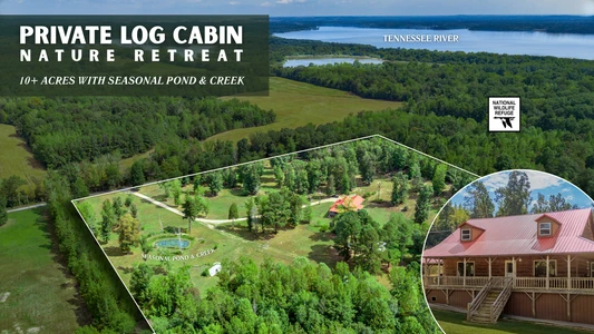

09/08/2025
$499,900
10.45 ac.
ACTIVE
Benton County - 1095 Mt Moriah Rd, Holladay, TN
This beautiful 3-bedroom, 2.5-bath log home sits on 10.45 acres in Holladay, TN, offering the perfect blend of rustic charm and modern convenience. Built in 2014 with approximately 2,100 sq. ft. of living space, the home features an open-concept main level with a spacious living room, eat-in kitchen, and a main-floor primary suite. The recently remodeled kitchen includes a center island and custom concrete countertops, while new flooring and trim throughout the main level add a fresh, updated touch. A whole-house water filtration system and high-speed fiber internet with a signal booster ensure comfort and practicality for everyday living.
Upstairs, two oversized bedrooms with large closets provide generous space for family or guests. The homes thoughtful design makes it ideal for a primary residence, hunting retreat, or mini-farm. With its combination of cozy log home aesthetics and updated finishes, this property is ready for both relaxation and productivity in a peaceful country setting.
Outdoors, the acreage is fully equipped for country living. The property includes a fenced pasture for livestock, a barn with goat shelter, an open storage barn, a 540 sq. ft. farm shop, and a 720 sq. ft. detached carport. A private pond and seasonal creek add to the charm, while fresh gravel on the driveway and parking area enhances accessibility. Perhaps the most unique feature is its border with the Tennessee National Wildlife Refuge, providing direct access to thousands of acres for hunting, fishing, and wildlife viewing. Deer, turkey, and bald eagles are frequent visitors, making this property a true haven for nature enthusiasts.
Located in Benton County, just over an hour to Nashville and about an hour to Jackson, this home offers both seclusion and convenience. With low annual taxes and no city restrictions, it provides an ideal lifestyle for those seeking to relocate, retire, or embrace the best of Tennessee country living. Whether your dream is a family home, a recreational getaway, or a small farmstead, this rare offering is ready to welcome you.

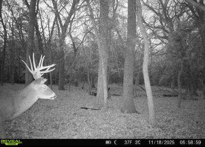

07/30/2025
$2,897,280
643.84 ac.
ACTIVE
Pottawatomie County - Green Valley Rd, Manhattan, KS
643.84 acres in Pottawatomie County, KS just east of Tuttle Creek Reservoir. Features rolling pasture, spring-fed draws, and a creek-like drainage. Excellent whitetail habitat with strong deer numbers and natural travel corridors. Cedar and hardwood timber throughout. Fully fenced with no structural improvements. Ideal for both cattle grazing and trophy deer hunting in a sought-after location.
Land
Located just 2.5 miles east of the Tuttle Creek Reservoir spillway in northeast Kansas, Krouse Brothers Ranch offers a rare opportunity to own a sizable piece of land in one of the state's most desirable recreational and agricultural regions. This 643.84 acre property features a strong combination of rolling native grass pasture, hardwood-lined draws, spring-fed drainages, and a central creek-like corridorall providing excellent habitat for both wildlife and livestock.
The terrain is diverse and scenic, with open meadows giving way to deep, timbered draws filled with cedar and mature hardwoods. Multiple springs emerge in these shaded areas, supplying year-round water sources that support healthy deer populations and provide dependable stock water. These natural draws create ideal bedding, cover, and travel corridors for wildlife, while also enhancing the land's overall grazing potential.
Northeast Kansas is widely recognized for its strong whitetail genetics and consistent production of mature bucks, and this property is no exception. With minimal pressure and natural terrain that funnels deer movement, it sets up well for both archery and firearm seasons. The mix of food, cover, and water across the property and surrounding area allows for multiple stand locations and season-long hunting opportunities. In addition to whitetail deer, the property supports a healthy population of wild turkeys and bobwhite quail, adding upland and spring hunting opportunities to an already well-rounded recreational offering.
Krouse Brothers Ranch sits in a region where large landholdings are tightly held and rarely brought to market. The surrounding area includes a mix of working farms, recreational tracts, and legacy ranches. Its close proximity to Tuttle Creek Reservoirone of Kansas' largest lakesadds year-round value with public hunting, fishing, and water recreation just minutes away.
There are no structural improvements beyond perimeter fencing, offering a blank slate for future developmentwhether it's a ranch headquarters, hunting cabin, or country residence. With productive pasture, well-maintained fencing, and top-end whitetail habitat, this is a true multi-use property that blends livestock production with premier hunting potential.
Region & Climate
Located near Manhattan, the region is known for its rolling Flint Hills landscape, productive pastureland, and exceptional deer hunting. The climate has four distinct seasons with warm summers, cold winters, and an average annual precipitation of 34 inches. This part of Kansas offers a balanced mix of agriculture, outdoor recreation, and small-town convenience.
Location
Krouse Brothers Ranch is located in Pottawatomie County, Kansas, just 2.5 miles east of the Tuttle Creek Reservoir spillway and about 5 miles northeast of Manhattan, KS. The property offers a secluded rural setting with convenient access to town, services, and major highways. Manhattan provides a full range of amenities including hospitals, retail, dining, and is home to Kansas State University. Air travel is available just 13 miles away at Manhattan Regional Airport (MHK), which offers daily commercial flights to Dallas and Chicago, while Kansas City International Airport (MCI) and Wichita's Eisenhower National Airport (ICT) are both just under two hours away. Nearby recreational options include Tuttle Creek State Park and Reservoir, which offers boating, fishing, camping, and hiking opportunities. The area is surrounded by a mix of large ranches, managed hunting ground, and productive farmland, making this location ideal for both livestock operations and serious hunters who value accessibility without sacrificing privacy.


03/14/2023
$174,000
5.1 ac.
ACTIVE
Sanpete County - Mount Pleasant, UT
Pine trees, meadow, power and water from a fill station. Enjoy views of the Sanpete Valley and surrounding mountains. Over 5 acres of heaven to spread out on and less then a quarter mile from a County paved and maintained road. Own your own land, NO HOA. Stop fighting the crowds! Come park your trailer, even lot's of your families and friends trailers. Plenty of room. Elevation is 7,013 feet. Minutes away from the Manti LaSal National Forest, Skyline Drive 350-mile trail system, lakes, hunting, fishing and much more. Come get away from it all and enjoy the beauty of nature and cool, crisp, clean mountain air! About 12 minutes from Mt. Pleasant which is and feels like a small-town but has many amenities like a hospital, restaurants, full service hardware and grocery stores, community indoor swimming pool, even a drive-in theater. You could install propane for gas and a septic system for sewer. Rocky Mountain Power is available for this lot. Water is a B-share which is an additional. You haul from a fill station. Within 100 yards of year round access in the winter time. This property is very close to the county road so you have easy access. Additional lots for sale. MLS map is correct. Buyer to verify all information. Google Earth or Maps are 39.47926, -111.40559


07/18/2024
$10,873,800
1726 ac.
ACTIVE
Hyde County - 416 Firetower Rd, Scranton, NC
KEY POINTS:
* Over 6.00 +/- Miles of Waterfrontage on the Pungo River and Intracoastal Waterway
* Over .75 +/- Miles of Waterfrontage on the Intracoastal Waterway
* 2.00 +/- Miles of Paved Road Frontage, Most on US Highway 264
* 4.30 +/- Miles of Interior Rock-Based Road System
* 10 Acre Lake for Great Duck Hunting and Fresh Water Fishing
POTENTIAL USES:
1. World Class Hunting Preserve
2. Corporative Retreat
3. 20+ Acre Lot Residential Subdivision
4. RV Park on ICW
5. Mini Home or Park Model Rental Development on ICW and Lake
6. Great Long Term Timber Investment
7. A Wonderful Private Estate
What a GREAT property with so many potential uses. This is truly a One-of-a-Kind property. With a large amount of waterfrontage and highway frontage, the possibilities are endless. The tract has a lot of Bear on it which in return creates World Class Hyde County Bear Hunting. As most people know, hunters come from all over the world to hunt Bear in Hyde County. With the tract being in the Atlantic Flyway, the Duck Hunting will be great, and as we all know, the fishing in the Pungo River and Pamlico Sound is "Off the Hook"! If you want a large private estate to build a large house on beside the ICW and sit on your deck and watch the Mult-Million-Dollar yachts go by going from the Northern States to the Caribbean, then this is your tract. The 10-acre lake will be a great addition for any project you choose. The high land on part of the ICW beautiful waterfrontage would be great to develop a RV Park on or develop a Mini Home Park Model rental subdivision project on. Overall, most of this tract is well drained and for Hyde County, the elevation of most of the tract is good. The property is located just 13 miles from Belhaven where there are good restaurants to eat fresh seafood. This tract is a GREAT TIMBER INVESTMENT property. Remember, the beautiful, planted pines are growing while you sleep. Regarding airports, Warren Field in Washington, NC, and in the opposite direction, the Hyde County Airport located in Englehard, NC are both just 40 miles away, and you can land a private jet at both locations. The property is located 156 miles from Raleigh, NC and 151 miles from Norfolk, VA. This is a rare find; do not let it pass you by. Once it is sold, it becomes someone else's dream. This property is shown by private showings only. Only serious inquires please.

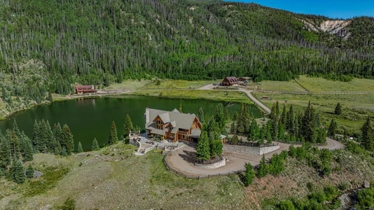

03/17/2025
$18,495,000
480 ac.
ACTIVE
Mineral County - 2418 USFS Rd 526, Creede, CO
Imagine owning a secluded sanctuary where every corner of the landscape invites you to connect with the raw beauty of the San Juan Mountains. Red Mountain Ranch is just that, a 480 deeded acre one of a kind property, offering an opportunity to raw natural resources, recreational possibilities, and unmatched privacy and access.
The property features two 7-acre lakes, over 3 miles of improved trout streams, and Red Mountain Creek, which flows through the entire length of the property. Red Mountain Creek, along with the lakes and streams, creates a private fishery that is completely under your management, offering exclusive fishing opportunities in its pristine waters. Abundant with brown trout, cutthroat trout, and rainbow trout, this fishery ensures a consistent and rewarding fishing experience while allowing owners to maintain the health and sustainability of its aquatic ecosystem. With no public access or pressure from outside anglers, the property provides a rare opportunity to preserve and enjoy a thriving, unspoiled fishery.
Elevations ranging from 9,300 to 9,700 feet offer spectacular views of Rhoda's Arch, the surrounding landscapes, and nearby 12,000+ foot peaks, including Piedra Peak, located just four miles away. The land itself is a diverse mix of aspens, spruce, and willows, further contributing to the property's raw beauty and ecological richness.
The estate includes multiple well-appointed structures, including an Engelmann Spruce Log Cabin boasting 4,193 square feet of living space with extraordinary high ceilings, a floor-to-ceiling three-story fireplace, and expansive windows showcasing the properties breathtaking views. Additional structures on the ranch include a large barn with a caretaker's apartment above, a second log cabin, a fully equipped workshop, and a dedicated yoga/exercise room near the main house.
Red Mountain Ranch is located in Game Management Unit 76, a highly sought-after area for big game hunting that is home to trophy-class wildlife, including 330 to 380 class bull elk and moose. The property is enrolled in the Landowner Preference Program and historically receives one bull elk tag, three cow elk tags, and one application for mule deer. This unit is truly considered one of the best Game Management Units in the region for hunting moose and elk, making it a prime location for hunters.
Recreational opportunities abound at Red Mountain Ranch, including hunting, fishing, swimming, hiking, rock climbing, and ATV exploration. The land's remote nature, year-round accessibility, and raw, unspoiled beauty make it feel like stepping back into the 1800s. It is a place where the land has remained largely untouched and protected from the outside world, providing a private sanctuary for those who call it home.


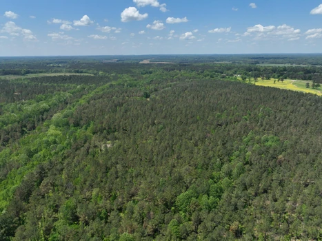
05/22/2025
$1,036,750
319 ac.
ACTIVE
Alcorn County - County Road 409, Rienzi, MS
319 Acres of Prime Timberland with Endless Potential Managed Pine, Hardwood, Hunting, Farming & More!
Located just minutes from town in a peaceful rural community, this exceptional 319-acre property offers a rare blend of timber investment, recreational enjoyment, and residential potential. Whether you're seeking a private hunting retreat, a long-term land investment, or a scenic location to build your dream home, this versatile property checks all the boxes.
Key Features:
Managed Pine Plantation:
Approximately 222 acres are planted in well-managed pine timber, providing current and future income potential. This timberland is ideal for the savvy investor or landowner interested in conservation or harvesting options.
76 Acres of Mature Hardwood Timber:
Beautiful mature hardwoods offer diversity in both landscape and wildlife habitat. The hardwood areas are not only visually stunning but also perfect for recreation and sustainable forestry. Jobes Creek runs through the property providing a year round water source.
Abundant Wildlife & Hunting Opportunities:
This property is a hunters paradise! Whitetail deer and wild turkey are plentiful throughout the land. Well-balanced habitat with woods, open fields, and water sources creates ideal conditions for wildlife management and hunting.
12 Acres of Food Plots and Row Crop:
Fertile cropland adds to the versatility and income-producing options of this property. Use the fields for row cropping, food plots, or potential pasture land.
Residential & Recreational Potential:
With its gently rolling terrain and beautiful wooded surroundings, this land offers numerous potential home sites. Whether you envision a rustic hunting cabin or a modern country home the possibilities are endless.
Excellent Road Frontage:
Extensive road frontage ensures easy access. The property is conveniently located near a quiet community yet only a short drive to town, making it both private and accessible.
Investment, Lifestyle, and Nature All in One Place
This 319-acre tract brings together the best of rural living with strong investment appeal. Whether you're looking for a hunting getaway, timber income, farmland, or a quiet place to call home, this property offers exceptional value and endless possibilities.
Dont Miss This Opportunity!
Land of this quality and size doesnt come along often. Contact us today for more details or to schedule a private tour.


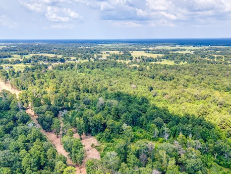
10/10/2025
$179,999
10 ac.
ACTIVE
Liberty County - 1044 County Road 2060, Hull, TX
Property Description
10 Acres in Eastern Liberty County, TX – Ready to Build!
This 10-acre ranchette offers the perfect balance of open space, modern amenities, and unbeatable location. Situated just 13 miles from Liberty and 49 miles from Houston, it provides the peace of country living with convenient access to nearby cities.
The property has been recently mulched and prepped for your dream build, whether you envision a custom home, barndominium, or a mobile home retreat. Power is available, and a water well will be required. Fiber optic internet is coming to the area, making it easy to stay connected while enjoying wide-open spaces.
With no restrictions and full flexibility, this land is perfect for anyone looking to invest, develop, or create their own Texas homestead.
*** Additional ranchettes ranging from 10 to 20 acres are also available, offering even more options for expansion or investment.***
Property Information
Parcel Size: 10 acres
State: Texas
County: Liberty
Nearest Cities: Hardin, Liberty, Beaumont, and Houston
Parcel #: 000126-000014-007, 000126-000013-009
Address: 1044 County Road 2060, Hull, TX 77564
Legal Description: Tract 7 (See Survey)
Zip Code: 77564
Annual Property Taxes: TBD
Agricultural Tax Exemption: No
HOA: No
HOA per Year: None!
Survey Available: Yes
School District: Hull-Daisetta ISD
Liens and Back Taxes: None!
Source Deed: Sent for Filing.
Title Status: Free & Clear!
Outgoing Conveyance: Warranty Deed
Property Features
Acres: 10
Dimension: 1,897 X 244
County: Liberty
Access: County Road 2060
Power: Available
Water: Well Required
Coordinates: 30.1832, -94.7248
Zoning: Vacant Land
Elevation: 66 FT
Terrain: Flat
Floodplain: No
Duplexes: Yes
Mobiles: Yes
Tiny Homes: Yes
Barndominiums: Yes
RV's: Yes
Camping: Yes


1
2
3
4
5
6
7

