

505± ACRES | CATTLE, HUNTING & RECREATIONAL PROPERTY | CHILDRESS COUNTY, TX
TBD County Road M, Childress, TX | Lat/Lng: 34.5855, -100.1101
$1,060,500
505 ac.
08/16/2026
ACTIVE
Description
505.00± acres north of Childress offering a versatile combination of cattle grazing, livestock improvements, wildlife habitat, hunting, fishing, recreation, rural homesite potential, and long-term land investment.
Primarily native and improved grasses cover the property, with rolling terrain, seasonal drainage features, approximately 60 feet of elevation change from northwest to southeast, and expansive views across the surrounding countryside. Good six-strand barbed-wire perimeter and cross-fencing divides the property into three rotational grazing pastures, with livestock water available throughout the grazing system.
CATTLE, HORSE & AGRICULTURAL IMPROVEMENTS
The property is well equipped for livestock operations with holding and working pens near the south-central portion of the acreage.
A substantial covered livestock and feed facility incorporates six horse stalls, with three stalls on each side, water faucets on both sides, and two additional livestock water tanks. The facility also incorporates a FodderTech hydroponic feed-growing system and integrated feed and tack storage. The facility and its components are welded together, creating a unified agricultural improvement, and the FodderTech hydroponic system will convey with the property.
A separately fenced area near the northwest corner of the east tract provides a convenient location for storing round bales of hay.
South Plains Electric Cooperative service enters the property from the north and extends generally through the middle of the acreage.
WATER
Water is an important feature of this property, with one strong working water well and multiple livestock watering locations.
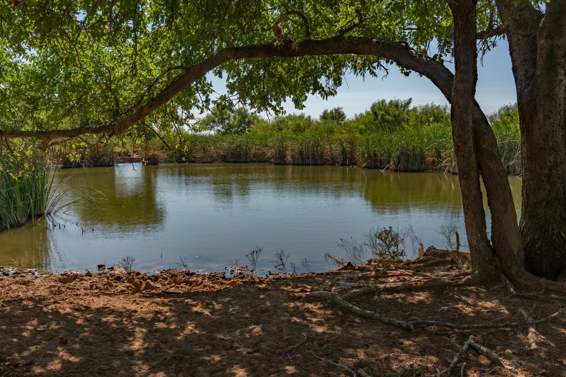
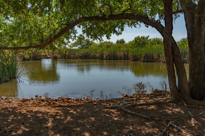
Two dirt stock tanks provide livestock water. According to the Seller, the west stock tank receives runoff from surrounding drainage areas and has not gone dry since it was constructed.
The east stock tank receives runoff and is also supplied with water pumped from the property's water well. According to the Seller, this tank remains full year-round and is stocked with catfish, perch, and recently added bass.
Two additional livestock water tanks and water faucets on both sides of the six-stall horse facility provide additional water for livestock.
The combination of the working water well, stock tanks, additional livestock tanks, cross-fencing, and water distribution throughout the three rotational pastures creates a practical setup for cattle and livestock management.
WILDLIFE, HUNTING & RECREATION
The property offers excellent wildlife and recreational characteristics created by its native cover, improved grasses, rolling terrain, seasonal drainages, stock water, and location between significant natural drainage corridors.
Buck Creek is approximately one mile north of the property, while the Prairie Dog Town Fork of the Red River is approximately 1½ miles to the south. Deer, hogs, quail, and dove are commonly observed on the property.
The well-supplied east stock tank adds another recreational component. According to the Seller, it is stocked with catfish and perch, with bass recently added.
There is currently no hunting lease in place, allowing a new owner flexibility in how the recreational aspects of the property are used or managed.
IRRIGATION POTENTIAL
There are currently no irrigation wells on the property. However, irrigated agricultural land is located immediately across the road northwest of the property and approximately one-half mile east.
The proximity of existing irrigation in the surrounding area may warrant further investigation by buyers interested in potential irrigation development. Buyers should independently investigate groundwater availability, drilling potential, well capacity, water quality, regulatory requirements, and economic feasibility with qualified professionals and the Gateway Groundwater Conservation District.
Seller and Broker make no representation regarding groundwater availability or the feasibility of irrigation development.
FSA INFORMATION
FSA records indicate historical base acreage consisting of:
165.60 acres Wheat Base - PLC Yield 142
5.20 acres Seed Cotton - PLC Yield 982
0.32 acres Grain Sorghum - PLC Yield 31
1.48 acres Unassigned Base
Buyers should independently verify current acreage, yields, program participation, and eligibility with the Farm Service Agency.
HOMESTEAD HISTORY & HOMESITE POTENTIAL
Evidence of three former homestead locations remains across the property, including old foundations and two old cisterns. One former residence was destroyed by fire more than 25 years ago.
Several very old farm implements, an early automobile chassis, and other remnants of past agricultural and homestead use also remain, providing an interesting glimpse into the property's history. No representation is made regarding the age, origin, historical significance, condition, value, or conveyance of these items.
The former homestead locations, acreage, county-road access, existing electric service, working water well, and rural setting provide several areas for buyers to evaluate for potential future homesite use.
ACCESS & LOCATION
Access is excellent. The overall property is bordered by county roads on all four sides:
County Road 18 - West
County Road L - North
County Road M - South
County Road 19 - East
Primary access is available from the south-central entrance on County Road M, with an additional gate on County Road L. The property consists of two tracts separated by a private road.
The property is located outside the limits of any municipality and is currently used for agricultural purposes.
Approximate distances include:
Childress - 17 miles
Hollis, Oklahoma - 18 miles
Wellington - 24 miles
Memphis - 33 miles
Quanah - 49 miles
Altus, Oklahoma - 52 miles
Elk City, Oklahoma - 98 miles
Amarillo - 118 miles
Wichita Falls - 125 miles
Lubbock - 153 miles
Abilene - 169 miles
Oklahoma City - 198 miles
Dallas/Fort Worth Metroplex - 239 miles
ADDITIONAL PROPERTY INFORMATION
Acreage: 505.00± acres
Soils: Predominantly clay loam. Buyers should independently evaluate soils and suitability for their intended use.
Topography: Rolling terrain with approximately 60 feet of elevation change from northwest to southeast. Portions of the property have historically been terraced.
Fencing: Good six-strand barbed-wire perimeter and cross-fencing. Three rotational grazing pastures.
Water Well: One strong working water well.
Surface Water: Two dirt stock tanks, including one supplied by the water well and stocked with fish according to the Seller.
Additional Livestock Water: Two livestock water tanks and water faucets at the covered livestock and feed facility.
Electric: South Plains Electric Cooperative service. Electric line enters from the north and extends generally through the middle of the property.
Groundwater Conservation District: Gateway Groundwater Conservation District.
Irrigation Wells: None currently on the property.
Rural Water: No known Red River Authority water line currently serves the property. Buyer should independently investigate availability.
School District: Childress ISD.
2025 Property Taxes: Approximately $374.86 with agricultural valuation in place. Buyer should verify taxes, agricultural valuation eligibility, exemptions, and potential rollback taxes.
Hunting Lease: None.
Grazing Lease: None.
Possession: Upon Closing and Funding.
Minerals: Subject to previous reservations of record. Any mineral interest owned by Seller, if any, will convey.
Wind Rights: All wind rights owned by Seller will convey.
Solar Rights: All solar rights owned by Seller will convey.
Water Rights: All water rights owned by Seller will convey.
LONG-TERM POTENTIAL
In addition to its current agricultural and recreational uses, the property's acreage, county-road frontage, existing electric infrastructure, water, and proximity to Childress may warrant consideration by buyers evaluating future homesites, investment, workforce housing, or other development-related opportunities.
Regional economic and development activity continues throughout portions of the Texas Panhandle and Rolling Plains, including energy, data center, infrastructure, and workforce housing projects.
Any future development or change in use is subject to buyer due diligence regarding access, utilities, groundwater, soils, topography, governmental requirements, market conditions, and other factors. Seller and Broker make no representation or warranty regarding development feasibility, utility capacity, subdivision potential, groundwater availability, irrigation potential, zoning or land-use changes, or suitability for any particular use.
DIRECTIONS
From the intersection of US Highway 287 and US Highway 83/62 in Childress, travel north on US Highway 83/62 for approximately 10.9 miles to County Road L. Travel east on County Road L for approximately 4.0 miles, then south on County Road M for approximately 0.3 miles. Travel east on County Road M for approximately 0.5 miles to the gate entrance on the north.
NO TRESPASSING. All showings are by appointment only and must be coordinated through the Listing Broker or a licensed real estate agent authorized by the Listing Broker. Please do not contact the owner directly.
This property is not for rent or lease, and owner financing is not available.
Details
County: Childress
Zipcode: 79201
Property Type One: Ranches
Property Type Two: Hunting Land
Property Type Three: Horse Property
Brokerage: Chad Holland Real Estate
Brokerage Link: www.chadhollandrealestate.com

Chad Holland
Chad Holland Real Estate
(806) 205-0497
By clicking the button, you agree to our Terms of Use and Privacy Policy.


Nearby Listings
Greer County, OK
$27,500 - 5 ac.
Greer County, OK
$54,250 - 10 ac.
Greer County, OK
$1,950,000 - 800 ac.
Greer County, OK
$1,300,000 - 460 ac.
Harmon County, OK

$920,000 - 517 ac.
Hardeman County, TX
$197,395 - 107 ac.
Donley County, TX
$2,339,590 - 851 ac.
Collingsworth County, TX
$5,678,750 - 1925 ac.
Harmon County, OK
$4,704,000 - 3360 ac.
Hardeman County, TX
$3,450,000 - 1070 ac.