
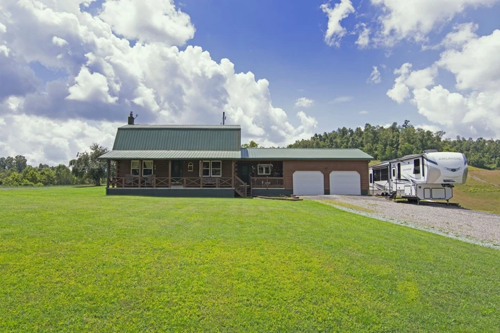
113 RAVEN VIEW LANE Lewisburg, WV
113 Raven View Lane, Lewisburg, WV | Lat/Lng: 37.8051, -80.4309
$375,900
0.3 ac.
06/02/2026
ACTIVE
Description
OVERVIEW
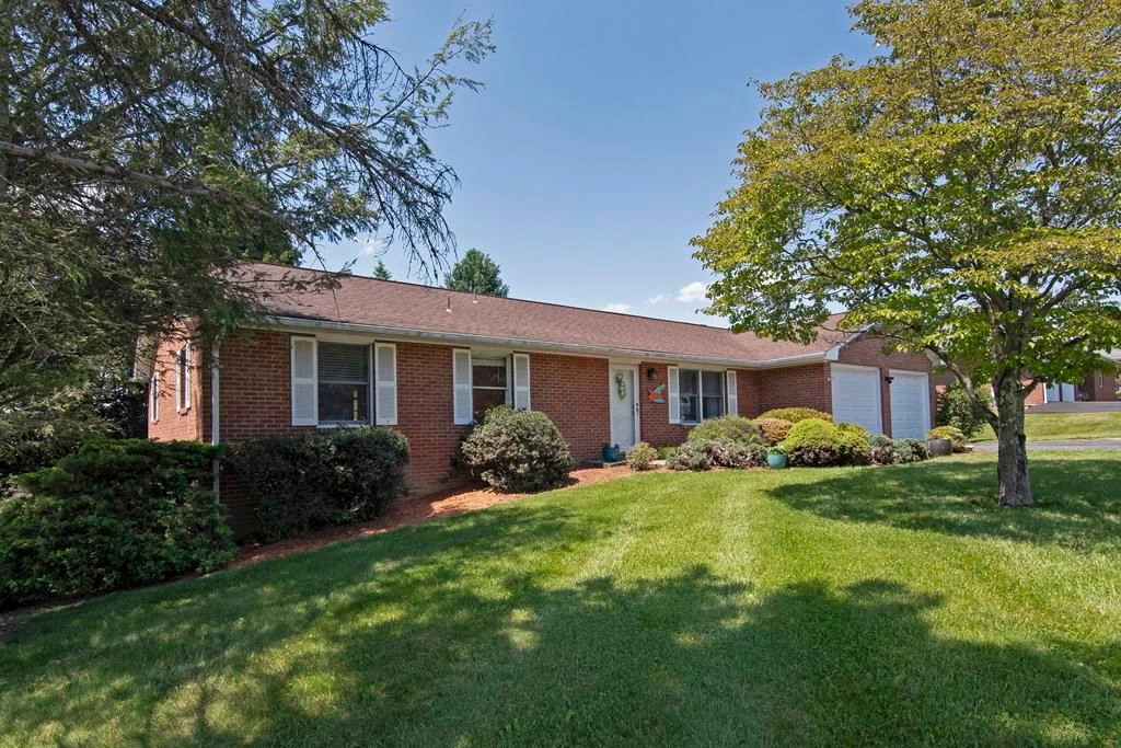
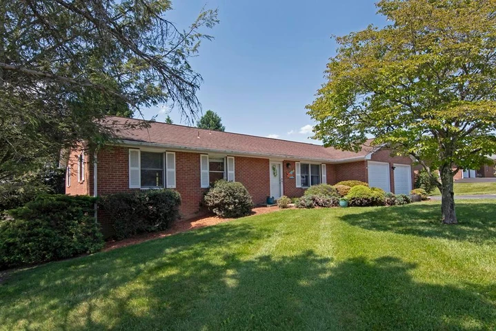
Foxfire Realty is proud to offer this warm and welcoming beautiful home on a corner lot in Historic Lewisburg West Virginia. The home has been freshly painted and new carpet has been installed in the living room and master bedroom. The home boasts a large fenced backyard, and is located just minutes from downtown Lewisburg where you will find a small town atmosphere with big town amenities. The home is within walking distance of the West Virginia School of Osteopathic Medicine WVSOM. This cozy well-maintained home is situated in the center of all the great activities for the nature enthusiast, fine dining, or just enjoying the Historic District.
HIGHLIGHTS
*1845 sq. ft. living space
*3 bedroom
*2 bath
*Exterior: brick
*Foundation: block
*Roof: shingles
*Garage: 2-car attached
*Driveway: pavement
*Landscaping: mature shrubbery and mulching
*Back yard: fenced
*Crawl space: walk in storage
*Heating and air: heat pump
*Living room: carpet and laminate flooring
*Carpet in bedrooms
*Kitchen: Laminate countertops, stainless steel sink, new vinyl flooring
*Laminate flooring in dining room and sitting room
*Setting room: laminate flooring
*Sunroom has wood flooring
*Solid surface countertops in bathrooms
*HOA fees $36 per year
Room Sizes:
Living room: 19x17
Dining room: 9.6x12
Kitchen: 15x12
Den: 12x15
Sunroom: 1x312
Master bedroom: 12x13
Master bathroom: 4x10
Bedroom #1 12x12
Bedroom #2 12x12
Bathroom: 5x12
Washer & dryer area: 4x7
Hall: 36x18
LOCATION
Address: 113 Raven View Lane, Lewisburg, WV 24901
Google Coordinates: 37.805054(N), -80.430664(W)
Within 1/2 mile of West Virginia School of Osteopathic Medicine. Drive to school in two minutes. Walk to school in less than 10 minutes.
UTILITIES
Water: Public
Sewer: Public
Cell service: excellent
ACCESS/FRONTAGE
The property fronts on Blackbird Way and Raven View Lane. The driveway connects to Raven View Lane.
ZONING
Lewisburg and Greenbrier County are subject to some zoning and subdivision regulations. All prospective buyers should consult the City Government, the County Commission, and also the Health Department for details regarding zoning, and building codes.
SCHOOLS
Greenbrier County School District
Public Elementary School:
Lewisburg Elementary School
Public Middle School:
Eastern Greenbrier Middle School
Public High School:
Greenbrier East High School
Colleges:
New River Community and Technical College (Lewisburg campus)
West Virginia School of Osteopathic Medicine
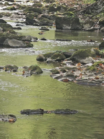
GREENBRIER RIVER
At 162 miles long, the Greenbrier is the longest untamed (unblocked) river left in the Eastern United States. It is primarily used for recreational pursuits and well known for its fishing, canoeing, kayaking and floating opportunities. Its upper reaches flow through the Monongahela National Forest, and it is parallelled for seventy-seven miles by the Greenbrier River Trail, a rail trail which runs between the communities of Cass and North Caldwell.
It has always been a valuable water route, with many of the important cities in the watershed established river ports. The river gives the receiving waters of the New River an estimated 30% of its water volume. Over three-fourths of the watershed is an extensive karstic (cavern system), which supports fine trout fishing, cave exploration and recreation. Many important festivals and public events are held along the river throughout the watershed.
The Greenbrier is formed at Durbin in northern Pocahontas County by the confluence of the East Fork Greenbrier River and the West Fork Greenbrier River, both of which are short streams rising at elevations exceeding 3,300 feet and flowing for their entire lengths in northern Pocahontas County.
From Durbin the Greenbrier flows generally south-southwest through Pocahontas, Greenbrier and Summers Counties, past several communities including Cass, Marlinton, Hillsboro, Ronceverte, Fort Spring, Alderson, and Hinton, where it flows into the New River.
Along most of its course, the Greenbrier accommodated the celebrated Indian warpath known as the Seneca Trail (Great Indian Warpath). From the vicinity of present-day White Sulphur Springs, the Trail followed Anthonys Creek down to the Greenbrier near the present Pocahontas-Greenbrier County line. It then ascended the river to the vicinity of Hillsboro and Droop Mountain and made its way through present Pocahontas County by way of future Marlinton, Indian Draft Run, and Edray.
GREENBRIER RIVER TRAIL
The 77-mile-long Greenbrier River Trail State Park is operated by the West Virginia State Parks and is a former C&O railroad grade now used for hiking, bicycling, ski-touring, horseback-riding, and wheel-chair use. The trail passes through numerous small towns and traverses thirty-five bridges and two tunnels as it winds its way along the valley. Most of the trail is adjacent to the free-flowing Greenbrier River and is surrounded by peaks of the Allegheny Mountains.
THE MONONGAHELA NATIONAL FOREST
The Monongahela National Forest was established in 1920 and encompasses about one million acres. Located in the north central highlands of West Virginia, the Monongahela straddles the highest ridges in the State. Elevation ranges from just under 1000 to 4863 above sea level. Variations in terrain and precipitation have created one of the most ecologically diverse National Forests in the country.
Visitors to this beautiful forest enjoy breathtaking vistas, peaceful country roads, gently flowing streams, and glimpses of the many species of plants and animals that inhabit the Forest. You will also see a working forest, which produces timber, water, grazing, minerals and recreational opportunities for the region and nation.
The landscape goals for management of the Monongahela are for a natural appearance and diverse forest, which provides outstanding dispersed recreation opportunities and supporting developed facilities. Dispersed recreation opportunities abound for hiking, backpacking, fishing, hunting, and mountain biking. Developed sites provide tourism destination facilities and base camps so important to the efforts of local Convention and Visitor Bureaus, local communities, and other non-government agencies. Forest Plan Management Prescriptions favor non-motorized recreation for ecological reasons.
The forest is noted for its rugged landscape with spectacular views, blueberry thickets, highland bogs and sods, and open areas with exposed rocks. In addition to the second-growth forest trees, the wide range of botanical species found includes rhododendron, laurel on the moist west side of the Allegheny Front, and cactus and endemic shale barren species on the drier eastern slopes.
The Monongahela National Forest was established in 1920 and encompasses about one million acres. Located in the north central highlands of West Virginia, the Monongahela straddles the highest ridges in the State. Elevation ranges from just under 1000 to 4863 above sea level. Variations in terrain and precipitation have created one of the most ecologically diverse National Forests in the country.
Visitors to this beautiful forest enjoy breathtaking vistas, peaceful country roads, gently flowing streams, and glimpses of the many species of plants and animals that inhabit the Forest. You will also see a working forest, which produces timber, water, grazing, minerals and recreational opportunities for the region and nation.
The landscape goals for management of the Monongahela are for a natural appearance and diverse forest, which provides outstanding dispersed recreation opportunities and supporting developed facilities. Dispersed recreation opportunities abound for hiking, backpacking, fishing, hunting, and mountain biking. Developed sites provide tourism destination facilities and base camps so important to the efforts of local Convention and Visitor Bureaus, local communities, and other non-government agencies. Forest Plan Management Prescriptions favor non-motorized recreation for ecological reasons.
The forest is noted for its rugged landscape with spectacular views, blueberry thickets, highland bogs and sods, and open areas with exposed rocks. In addition to the second-growth forest trees, the wide range of botanical species found includes rhododendron, laurel on the m
Details
County: Greenbrier
Zipcode: 24901
Property Type One: Residential Property
Brokerage: FoxFire Realty
Brokerage Link: www.foxfirenation.com

Richard Grist
FoxFire Realty
(304) 645-7674
By clicking the button, you agree to our Terms of Use and Privacy Policy.


Nearby Listings
Monroe County, WV

$325,000 - 113 ac.
Greenbrier County, WV
$495,000 - 17 ac.
Nicholas County, WV

$219,000 - 73 ac.
Botetourt County, VA
Auction - 91 ac.
Monroe County, WV
$365,000 - 82 ac.
Fayette County, WV
$1,050,000 - 153 ac.
Greenbrier County, WV

$699,000 - 49 ac.
Summers County, WV

$2,200,000 - 140 ac.
Greenbrier County, WV

$399,000 - 5 ac.
Greenbrier County, WV

$425,000 - 1 ac.