Orange County, Vermont Land For Sale (5 results)
Want to post your listings on AcreValue? View Listing Plans
AcreValue offers multiple types of land for sale in Orange County, so if you’re looking for a new ranch, farm, recreational property, hunting ground, developmental property, or land investment you’ve come to the right place. Regardless of what your needs or objectives are for your land, we have a large inventory of available parcels that are updated regularly. Therefore, it’s very likely that we have the perfect parcel that meets all the search criteria & specifications that you’ve been searching for. Additionally, because our land for sale listings are always being updated due to the frequency of land being sold or new land listings being put on the market, make sure that you are checking back with AcreValue regularly for updates. When you find the perfect land parcel and you are ready to take the next steps you can easily connect directly with the listing agent to help you facilitate your land purchase. Browse AcreValue's Vermont land for sale page to find more potential opportunities in Vermont that fit your needs. We wish you the best of luck in finding your next ranch, farm, recreational property, hunting ground, developmental property, or land investment.


07/21/2024
$705,375
515 ac.
ACTIVE
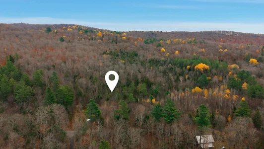
Orange County - Powder Spring Road, Topsham, VT
The property features opportunities to take over an attractive, long-term investment, which has been well-managed over time for high-quality northern hardwood timber. Potential building sites can also be easily found throughout the land.
Notable highlights include:
- Managed timber resource, well-positioned for future volume and value growth;
- Sugar maple-dominated timber resource worth around $579,300;
- Sugarbush management and development potential, owing to 40% stocking of sugar maple and excellent slopes;
- Developed internal forest road access;
- Desirable location in central Vermont, close to population centers such as Barre and Montpelier, and close to Interstate 91.
Location
Powder Spring Forest is located in north Topsham, Vermont, a rural town in Orange County mostly consisting of forested acreage, farms, and small homesteads. The town is situated just east of the Green Mountains and west of the Connecticut River Valley, characterized by rolling hillslopes and many rivers, including the Waits, which drains east into the Connecticut River, and the Powder Spring brook, from which this forest gets its name.
While Topsham exemplifies the character of rural Vermont, with its peaceful ambiance and quaint rural character, the town and the subject property are easily connected to local population centers and amenities. Vermont Route 25 and U.S. Route 302 serve to connect Topsham with Barre to the northwest (25 miles away), Bradford (12 miles away to the southeast), and St. Johnsbury (31 miles northeast). In Bradford, there is access to Interstate 91, a major travel corridor connecting Vermont to Massachusetts and Canada, and in Barre, there is access to Interstate 89, connecting to major cities and cultural centers of Burlington, VT, and Manchester, NH. Boston, MA, and Hartford, CT, are a 3-hour drive south.
Access
Legal access to Powder Springs Forest is provided by several modes, including Town Class 3 & 4 roads and private access points.
Powder Spring Road provides a point of access to an old woods road that parallels the brook. This former roadway provides sufficient access to the lands extreme eastern slopes as they tilt to the brook. This small region of the forest supports an attractive 35 to 45-year-old sugar maple stand.
Sanborn Road offers frontage for a driveway point permitting access to another small section of the forest which slopes to the east.
Currier Road is the primary access point to the forest, which leads to a 1,600 section of class 4 road before entering the southern section of the property. Once on the property, a developed internal road runs 2,600 to a log landing which provides access to all of the propertys western higher elevation. Another internal road runs nearly 3,600 to the east and then north, providing functional access to the lands entire eastern half. Both roads can be seen on the property photo maps.
Frost Road provides legal Class 4 access to a small section of the northern end of the property. However, this area has traditionally been accessed from the established roads that originate on the southern side of the forest.
Site Description
The property has been shaped by its former uses, including an intensive period of farming and homesteading going as far back as the late 1700s. Field evidence, such as barn and house stone foundations, stone walls ,and wire fences, covers the propertys landscape, indicating that nearly all of the land was formally used for some form of agricultural activity. Following abandonment in the late 1800s, as the country grew more industrialized, the farmlands were steadily abandoned and allowed to grow back to forest.
The property is situated in a generally high-elevation region of Vermont. The land is characterized by several hills, ravines, and drainages which offer aspects in all directions. The southern and eastern-facing hillsides especially would benefit from tree clearing in order to maximize potential views, which would offer vistas of the White Mountains to the east. Elevation ranges from around 1,500 near Powder Springs Road, where the land rises up a prominent hillside (1,900) before falling again to the west, where flatter land contains wetlands and low-lying creeks. Headwater streams of Powder Springs Brook are found here, running through the property heading south.
Slope conditions on the property are rolling and moderate overall, and the terrain is easily accessible by foot or via logging equipment during forest management.
Timber
Timber data in this report are based on a timber inventory conducted in December 2022, with the purpose of establishing Capital Timber Value (CTV) by F&W Forestry Services, the owners forest manager. 91 inventory points were sampled (1 plot per 5.4 acres), covering a 486 X 486 grid using a 15-factor prism. Sampling statistics are 13.4% standard error for sawlog products and +/-7% for all products combined at the 95% confidence interval. Upon applying growth for 1 season at regional FIA data growth rates, the timber data reveal a total sawlog volume of 2,243 MBF (Intl scale) (4.4 MBF/acre), with 6,435 pulpwood cords (13.0 cords/acre). Combined total commercial per acre volume is 18 cords, a figure about average for the region. Stumpage values were assigned to the volumes in May of 2024, producing a property-wide Capital Timber Value (CTV) of $566,100 ($1,143/acre). See the Timber Valuation in this report for details.
Species Composition:
The species composition is 84% hardwoods and 16% softwoods. Species composition for all products combined is led by sugar maple (44%), followed by yellow birch (12%), white ash (9%), and red maple (8%). Softwood volume mainly consists of spruce/fir (8%) and pine (3%). Scattered red pine is also found in some areas of the forest. The sawlog volume breakdown is led by sugar maple (46%), followed by spruce/fir (14%), and yellow birch (13%), along with small levels of various common associates. The primary species all have benefited from strong historical (and current) markets for their various end products, ensuring the likelihood of robust asset appreciation from stumpage price growth.
Stocking and Stem Quality:
Stocking is variable due to past timber harvesting, which has targeted various areas of the property. Much of the property is found as mature, even-aged forest, while other acreage has been harvested and is now a less dense overstory growing atop a dense understory. Basal areas in the stands range from 40-120 ft2/ac, and show 69% Acceptable Growing Stock.
Sawlog Value/ Management History:
Sawlog value is dominated by sugar maple (46%) followed by spruce/fir (14%) and yellow birch (13%), with the small balance held by red maple, white ash, and others.
The 2023 forest management plan identifies fifteen forest stands. Most stands have been harvested in the past two decades using a combination of shelterwood, group selection, and overstory removal harvesting. The most recent harvesting on the property occurred in 2018.
Diameter Distribution:
The diameter distribution indicates a wide range, with strong representation from advanced saplings established during harvesting over the years. Poletimber in the 6-10 diameter range is also well-represented. The diameter distribution clearly shows the results of a managed forestland, with the bulk of the stocking being found in small logs and large poletimber nearing sawlog size.
Sugarbush Option
The timber data indicates a total of 16,400 potential maple taps from the 9 and greater size classes, with 84% of the taps from sugar maple and the balance red maple. Tap density per acre is variable, ranging from around 20 per acre in previously harvested areas to 60-70 in more dense hardwood stands. Sugaring use would be an excellent additional income source if portions of the property were given over to taps. Electrical power is available a short distance from the property on Currier Road or on the Powder Spring Road, and slopes offer a diverse aspects for multiple setup options.


09/23/2024
$237,000
221 ac.
ACTIVE
Orange County - New Boston Road, Thetford, VT
Introduction
The ownership is selling their property in two separate parcels, divided by the town line. The +/-60 acre Strafford parcel is well suited to future home development with paved town road frontage and roadside electric service. The +/-220 acre Thetford parcel is well suited to a camp or seasonal off-grid home development with beautiful local views.
Both parcels have significant frontage along the West Branch of the Ompompanoosuc River. Both parcels have Restricted Use Areas associated with the reclaimed Elizabeth Copper Mine site.
Location
The parcels are situated in east central Vermont, 11 miles from the New Hampshire border. The local landscape is dominated by abundant forestland, with small farms in the valleys and widely scattered homes along roads. This area is part of the West Branch of the Ompompanoosuc River watershed, a sizable river that runs along both parcels.
The hamlet of South Strafford is 1.7 miles to the northwest and is host to a general store. Norwich, Vermont, located 10 miles to the south, is the closest large town offering the most amenities. Interstate 91 is just east of Norwich, and across the Connecticut River is the Town of Hanover, host of Dartmouth College. Boston is just over a 2 hour drive.
Access
The land is accessed from New Boston Road, a graveled, town maintained road. There is no electric power along this part of the road. A +/-400 right of way road runs from the town road to the property boundary and gate. From the gate, a gravel road heads into the land in a northern direction for +/-2,325 to the lands open meadow and likely best camp location. From this point, the road continues through the land for another +/-3,950 (this last section of the road will need some maintenance before its drivable again; however, much of the road is graveled & ditched).
Site Description
The lands primary feature is its nearly 1/2 mile of river frontage at its northern end. Two old woods trails head to the river providing good access to this scenic water resource.
Given the lands access, distance to electric power, Restricted Use Area, and opposing solar array, the highest and best use is likely a camp/seasonal home development, recreation, and/or forest management. A meadow at the end of the access road (see maps for location) offers attractive views to the west and north, a prime location to develop a large camp or seasonal home. There is a small woodland pond near the field that contains amphibians such as newts and frogs, and would be used for drinking water by deer and other animals in the forest.
Elevations range from 730 along the river to 1,200 near the SE boundary. The terrain is mostly gently sloping, however, with steep terrain along the river.
Timber
The forest can be considered aesthetically scenic as it has been several decades since forest management has occurred, resulting in a high canopy thats easy to walk through. Generally, on the higher elevation and more level sites, northern hardwood species dominate. On the steeper slopes and along the river, dense hemlock stands are common, with large legacy trees throughout, holding diameters in the 18-24 size class. The hardwood stands have a range of diameters, are fully stocked, and include large legacy stems. The youngest age class was created from harvesting that occurred +/-24 years ago.
Solar Lease
Portions of the Restricted Area are occupied by a solar project operated by Greenwood Infrastructure, under a lease in which the lease period could remain for an additional +/-42 years. Annual lease income is $1.00. A copy of the lease agreement is available upon request.
Restricted Use Area
The property is part of the former Elizabeth Copper Mine whose reclamation and stabilization was finalized by the EPA. As part of EPAs reclamation/remedial action plan, the land includes a Restrictive Use Area covering a total of 79 acres as represented on the property maps and survey. This area can not be developed or disturbed in the future per the Grant of Environmental Restrictions, Right of Access, and Easement deed. Copy provided upon request.

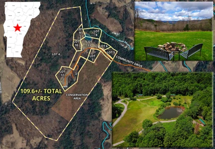
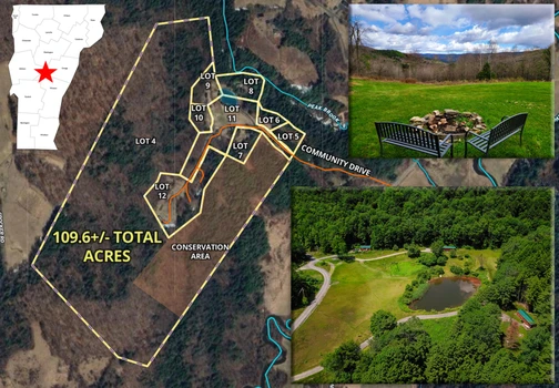
11/21/2025
$1,500,000
109.6 ac.
ACTIVE
Orange County - 250-566 Community Dr, Randolph, VT
109.6 +/- Acre, 9 lot subdivision offering a fantastic year-round AirBnB/Rental Tiny Home Investment, located in Randolph VT. 6 Beautiful tiny home cabins, 2 Yurts, 2 RV/future cabin spots & two tenting areas. Water, septic, Internet, all provided. Fantastic for an Intentional Community sleeping up to 34, whether simple co-housing, an eco-community, art center, mentoring village, the possibilities are endless. What makes this unique is that it is not a bunch of buildings placed on a single lot. The seller has produced a community where each residence is or can be placed on its own individual financeable and ownable lot. This simplifies the group purchase and ownership division. As an investment property it has a strong rental history and with the newly completed construction 2026 gross numbers should be over $200,000 with plenty of expansion potential. 2 lots have no cabins at this time, the 2 Cabin/RV spots could have cabins placed on them and further subdivision is possible. The property is very private, with nice views from many places. There is a 0.5-acre spring fed swimming pond and 3-acre open community area with large garden space. 87.7+/- Acres of the property is Timberland offering walking trails and lots of recreational opportunities, 22 acres of this is permanently conserved. The seller has painstakingly made sure that all state and local permits are in place. Minutes off I89, very close to Vermont State University, Vermont Law School & Norwich University.

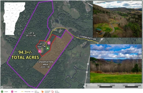
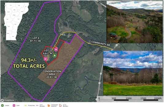
11/14/2025
$635,000
94.3 ac.
ACTIVE
Orange County - 566 Community Dr, Randolph, VT
Investors, homesteaders, tiny home enthusiasts, get ready to experience this unique 94.3+/- acre property in beautiful Randolph VT. Two legal parcels, 6.6+/- acres and 87.7+/- acres. The property includes a log cabin park model home, a custom tiny home, a new full homesite currently rented by a 5th wheeler and two tent platforms. A drilled well provides water to all of the structures. Power and DSL are connected to the tiny homes with Fiber available and conduit installed. Seller rents the log cabin, tiny home and 5th wheeler site on a m-to-m basis. Tent platforms were not rented this year. There are (2) three-bedroom septic systems connected to the log cabin & 5th wheeler site. 4 bedrooms of extra capacity remain. Custom tiny home uses a composting toilet. Income approximately $3110 p/m with room for expansion. All of the 87.7+/- acres are in the Vermont Current Use tax reduction program for forestry. 87.7+/- acre lot is wooded with 22.4 acres of this being conserved for recreational/forestry use only. The remaining may be subdivided developed, etc. The 6.6+/- Acres is where all of the structures were built. The property is accessed by a beautiful private road (ROW) called Community Drive. Maintenance will be shared with two private homes and an Airbnb community. Very nice views from the log cabin area. Great opportunity to build your dream home and have rental opportunities on your property. Also for sale is a 5 lot Airbnb tiny home community see MLS#5057088.

01/18/2026
$349,000
67 ac.
ACTIVE
Orange County - 230 Taylor Valley Road, Strafford, VT
Welcome to premier & exclusive Vermont living at 230 Taylor Valley Road in scenic Strafford. This expansive 67-acre parcel sits high above a peaceful valley, offering stunning views and a true sense of seclusion. Nestled at the edge of a beautiful valley, the land is rich with a mix of hardwood and softwood trees, creating the quintessential Vermont forest setting. With southeast exposure and abundant natural light, this is the ideal location to build your dream home surrounded by nature. Whether you're envisioning a modern mountain retreat or a classic New England homestead, the groundwork has already been laid complete with a State-approved septic design, building plans, and proposed driveway plans in place to help bring your vision to life with ease. Bordering a lovely tree farm and set in one of Vermont s most picturesque towns, this property offers privacy, tranquility, and a lifestyle in harmony with the outdoors. Make your Vermont dream a reality at 230 Taylor Valley Road.


1

