Essex County, Vermont Land For Sale (7 results)
Want to post your listings on AcreValue? View Listing Plans
AcreValue offers multiple types of land for sale in Essex County, so if you’re looking for a new ranch, farm, recreational property, hunting ground, developmental property, or land investment you’ve come to the right place. Regardless of what your needs or objectives are for your land, we have a large inventory of available parcels that are updated regularly. Therefore, it’s very likely that we have the perfect parcel that meets all the search criteria & specifications that you’ve been searching for. Additionally, because our land for sale listings are always being updated due to the frequency of land being sold or new land listings being put on the market, make sure that you are checking back with AcreValue regularly for updates. When you find the perfect land parcel and you are ready to take the next steps you can easily connect directly with the listing agent to help you facilitate your land purchase. Browse AcreValue's Vermont land for sale page to find more potential opportunities in Vermont that fit your needs. We wish you the best of luck in finding your next ranch, farm, recreational property, hunting ground, developmental property, or land investment.

01/06/2026
$5,100,000
5225 ac.
ACTIVE
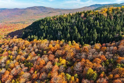
Essex County - East Haven, VT
LandVest is pleased to present Starr Mountain, a premier Vermont timberland ownership offering an exceptional opportunity for natural capital investment and long-term forest stewardship.
Located within the rolling green hills of the East Haven Range, Starr Mountain encompasses a large, contiguous acreage with favorable growing conditions and reliable access. The property benefits from a long history of professional, sustainable forest management, resulting in a high-quality mid-rotation hardwood resource complemented by meaningful softwood diversity.
A June 2025 timber inventory indicates a well-stocked forest carrying 4.7 MBF of sawtimber (sawlogs and tie/pallet) and 15.2 cords of pulpwood, with an average stocking level of 24.5 gross cords per forested acre. The species composition is led by sugar maple, yellow birch, and spruce/fir, positioning the forest for continued biological growth and value appreciation.
The property offers multiple avenues for near- and long-term returns, including selective silvicultural harvests, carbon sequestration opportunities, and recreational leasing. A Forest Legacy conservation easement protects the land for ongoing timber production and recreation while allowing for active, flexible forest management.
Starr Mountain enjoys access to regional pulpwood and sawtimber markets and is enrolled in Vermonts Use Value Appraisal (UVA) program, providing favorable property tax treatment.
This offering represents a rare opportunity to acquire a large, single-tract timberland holding in the heart of Vermonts Northeast Kingdoma region known for its working forests, conservation ethic, and enduring land value.
Proximity:
Saint Johnsbury, VT 40 minutes
Hanover, NH 1.5 hours
Boston, MA 3.5 hours

12/09/2025
$20,000,000
260 ac.
ACTIVE
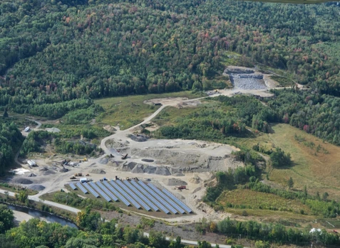
Essex County - 6489 Vermont 102, Lemington, VT
Operating Aggregate business in Northern Vermont and New Hampshire. 3 Gravel pits located in Essex County, Vermont and 1 located in Coos County New Hampshire all along the Connecticut River, producing ledge, gravel and sand. Will come with 3 solar panel leases, 2 workshops, scale and scale house and all heavy equipment. Price and equipment negotiable.

10/22/2025
$595,000
238 ac.
ACTIVE
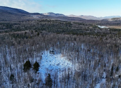
Essex County - 501 Fellows Road, Guildhall, VT
The Mountain View Cabin offers a secluded retreat perfect for those seeking modern amenities mixed with rural charm and outdoor recreational opportunities. The property features:
-A newly constructed cabin with off-grid power, kitchen/living space, and loft
-Expansive views of New Hampshire's Presidential Range
-Newly constructed driveway leading from Fellows Road, a public Class 3 highway close to Vt-102
-Professionally constructed Atv/Recreational trails throughout the forest
-Mixed timber resource offering future value appreciation
-Direct access to Vast snowmobile trails, with ATV trails located nearby
The Mountain View Cabin is located in quaint Guildhall, Vermont, just west of the border between Vermont and New Hampshire. Just east, the Connecticut River forms the state line and offers fishing and paddling opportunities, especially on the Northern Forest Canoe Trail, which winds from Old Forge, NY, to Fort Kent, ME. The surrounding landscape on the Vermont side is primarily forested, with thousands of acres of public or publicly-accessible forests, trails, and roads available for exploration. Surrounding development is limited, with only scattered homes and camps dotting the landscape and featuring small farms in the valley areas. In New Hampshire, only a short drive away, the town of Lancaster contains many local and unique amenities, including dining, a brewery, shops, a theater, and emergency services. Only 12 minutes away, the Gateway to the Great North Woods ensures access to services when needed.
The property is well-situated for the outdoor enthusiast. Vermont and New Hampshire snowmobile and ATV trails are nearby to the south and north, with a Vast snowmobile trail crossing the property to the south. Kingdom Heritage Conservation Lands (Vt) to the west provides ample opportunities for hiking, biking, fishing, hunting, and exploration, while in New Hampshire, the White Mountain National Forest is found only slightly east of Lancaster. To the north, the Great North Woods of Pittsburg offers many of the same opportunities. For investors, the property offers great potential for short-term rental to outdoorspeople seeking these activities.
Burke Mountain, a renowned destination for mountain biking and alpine skiing, is located 22 miles to the west, about a 45-minute drive along the scenic Granby Road. The Bretton Woods Ski Area and Mount Washington, home to the famous Tuckerman's Ravine and scenic toll road, are just 29 miles to the south. The property is just minutes from Us-2 and Us-3, serving destinations in all directions. Burlington, VT, is approximately 2.25 hours away. Travelers from Boston, MA, and Portland, ME can expect a 3.5-Hour journey.
Access to the property is easily found from Fellows Road, a maintained Class 3 public road originating from Vt-102. From here, a recently-built gravel driveway winds 0.67 miles until reaching the height of land, the pole barn, and the camp. Both Fellows Road and the driveway are suitable for all vehicles.
Along with the camp, the property features 238 acres of scenic forestland, mostly hardwood timber, although with softwood included in certain stands. The forest is generally young, having been logged around 30-40 years ago, but has since regenerated with small pole-sized hardwood timber. Certain areas were not harvested and boast more mature growing stock. The species mix is predominated by maples, ash, birch, and beech, representing a typical Vermont hardwood species mix. The property is well placed for future asset appreciation as these stems grow into sawlog classes.
A main feature of the property is the extensive trail network, some of which is professionally constructed, which allows easy access to all areas of the property for powersports riding, hiking, hunting, dog walking, skiing, and mountain biking. Trails have been maintained by the landowner over the years and are ready for immediate use. Due to the mixture of forest species and age classes, wildlife signs of moose, deer, bear, and partridge are easily found in the forest. Located in WMU E2, short-term rental investors may find demand from hunters and anglers looking to explore the North Woods.
Perched on a hillside overlooking the Presidential Range of the White Mountains, the Mountain View Cabin combines modern amenities with long-range views and a deep-woods ambiance. This charming retreat boasts multiple entrances from front and rear porches, inviting guests to transition between the outdoors and the cozy interior. Powered by an eco-friendly solar array and equipped with reliable battery storage, the cabin not only promises sustainable living but also allows you to fully embrace the peaceful surroundings. Enjoy breathtaking sunrises and sunsets from your expansive porches, where you can unwind and savor the deep-woods ambiance that makes this property truly special.
Step into this charming cabin and experience the perfect blend of rustic charm and modern convenience. The inviting mudroom/living room area is not only a cozy gathering space but can also easily transform into a comfortable extra bedroom for your guests. The bright and airy kitchen/dining area features a propane cooktop, sink, and sliding-glass door to the front porch. Upstairs, the loft serves as the primary bedroom, offering a peaceful retreat with scenic vistas. This charming cabin combines comfort and functionality with the benefits of solar power and battery storage.


09/08/2025
$261,000
130 ac.
ACTIVE
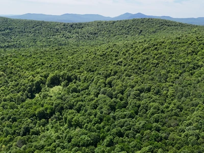
Essex County - 955 Hall Road, Lunenburg, VT
Located in rural Lunenburg, Vermont, this property offers the perfect blend of access to local amenities with the seclusion of Northeast Kingdom forestlands. The surrounding landscape is one of vast, undeveloped timberlands, mixed with well-maintained camps off Hall Road, which also serves as an ATV and snowmobile trail. Property highlights include:
-Standing timber value of $140,500, with a promising timber asset appreciation outlook
-Attractive forest conditions, with minimal low shrubs and regeneration creating easy walking conditions
-Developed access off Hall Road, with a built driveway (right-of-way) accessing potential camp sites
-Mostly gentle terrain with trails ready to be upgraded
Location
The forest is located in the town of Lunenburg, in the Northeast Kingdom, which borders New Hampshire and the Connecticut River. Much of the area is rural and characterized by a heavily forested landscape, with homes generally scattered, except for clusters found in small hamlets and along Neal Pond. Small farms along the Connecticut River are also prominent, contributing to the region's traditional working-land character. The landscape to the north is almost entirely forested and includes several larger timberland blocks under both private and public ownership. Neal Pond is a short distance to the south and features a public launch for fishing and boating. Lunenburg Village lies just 5.5 miles from the property via Route 2. The village offers a convenience store, post office, elementary school, and town municipal offices. The drive to the village along Pond Road passes occasional year-round homes, while the immediate Hall Road area is known for its numerous seasonal camps.
Lancaster, New Hampshire, is the closest major town, located about 10 miles east along the Connecticut and Israel Rivers. Lancaster serves as a regional hub with a vibrant downtown, offering full amenities and earning the reputation of the Gateway to the Great North Woods. The town can be found bordering the scenic, rolling mountains of the Kilkenny Range within the White Mountain National Forest. For broader regional access, Boston and Portland, Maine, are approximately a 2.5-Hour drive to the south and southeast. There are sites available for potential camp-building near the existing cleared log landing or at several other locations throughout the forest.
Access
The property can be accessed via Hall Road, which is a Class 4 town road. This is followed by a legally deeded 50-foot-wide right-of-way (Row) that provides direct access to the property, stretching approximately 1,100 feet.
Although Hall Road is not maintained by the town and is not plowed during the winter months, nearby camp owners routinely maintain the road, ensuring it remains passable. During the winter, Hall Road serves as a significant Vast snowmobile trail.
Property Description
The land is primarily characterized by gentle slopes, with some steeper sections forming a hillside that faces southwest. The elevation ranges from approximately 1,620 feet above sea level (Asl) in the east, where a log landing and potential campsite locations are found, to about 1,940 feet ASL at the height of land to the north. A small stream drains this hillside, flowing southwest and eventually forming Hall Brook, which empties into the Connecticut River to the west.
The ground conditions and slopes are favorable for timber harvesting and recreational activities, with very little difficult terrain limiting access. Some areas of the property are upland and quite dry, while other regions to the west contain more softwood timber and riparian zones, providing excellent wildlife habitat.
Forest trails, created from previous logging activities, can be found throughout the property, offering access for off-trail snowmobiling, ATV riding, hunting, and hiking. Hall Road itself serves as a Vast Snowmobile Trail during the winter months, providing access to major trails leading to points of interest in Vermont and New Hampshire. There are several potential camping sites available near the existing cleared log landing and at various points throughout the forest.
Timber Resource
Timber data in this report is based on a comprehensive timber inventory completed in June of 2023 to establish Capital Timber Value (Ctv), then grown forward two growing seasons using current FIA growth data. Thirty-six inventory points (1 plot per 3.6 forested acres) were sampled, covering a 415' x 415' grid using a 15-factor prism. Sampling statistics are 30% standard error for sawlog products and 13.7% for all products combined at the 95% confidence interval.
The timber data revealed a total sawlog volume of 481 MBF International scale (3.7 Mbf/Acre), with 2,751 pulpwood cords (21 cords/acre). The combined total commercial per-acre volume is 28.4 cords, a figure above average for the region. Stumpage values were assigned to the volumes in August 2025, producing a property-wide Capital Timber Value (Ctv) of $140,500 ($1,072/Acre). See the Timber Valuation in this report for details.
Species Composition
Hardwoods dominate the species composition, accounting for 89% of the total volume, while softwoods make up 12%. The overall mix closely mirrors that of the surrounding region, with sugar maple comprising 47% of the total volume, followed by red spruce (32%), white ash (8%), yellow birch (6%), black cherry (3%), and miscellaneous hardwoods.
The sawlog volume breakdown reflects strong market demand, led by sugar maple, yellow birch, white ash, spruce/fir, white birch, aspen, and black cherry. A notable attribute is the limited presence of beech in both the overstory and understory.
Sawlog Value
Sawlog value is concentrated in sugar maple (53%), red spruce (28%), white ash (11%), and yellow birch (4%), with the balance in miscellaneous species.
Diameter Distribution
The average diameter for all products combined is 11.1 inches, while sawlogs average 11.7 inches. Sugar maple, the dominant species, averages 13.0 inches. Overall, the forest consists of two primary age classes: an older cohort, roughly 70 years old and scattered throughout the property, and a younger cohort established about 35 years ago following a heavy harvest.
Stocking & Stem Quality
Fully stocked stands represent forest density. The average basal area (Ba) is around 97 ft on 296 stems per acre. Stem quality is well above average for the region, with acceptable growing stock BA at 81 ft. The younger age class is high in density, with straight, clean, and tall stems perfectly positioned for future asset appreciation and for shifting products to higher-value sawlogs and veneer. The older age class represents a strong income opportunity the next time the property is silviculturally treated.


07/21/2025
$5,100,000
5225 ac.
ACTIVE
Essex County - East Haven, VT
LandVest is pleased to bring to marketStarr Mountain, an attractive Vermont timberland ownership offering an exceptional natural capital investment and forestland stewardship opportunity.Situated amongst the rolling green hills of the East Haven Range, Starr Mountain offers a large expanse of contiguous acreage with favorable site conditions and good access.The property has an extensive history of professional and sustainable forest management, providing a quality mid-rotational hardwood resource balanced by meaningful softwood diversity.A fresh June-2025 timber inventory shows a forest carrying 4.7 MBF/acreof sawtimber (sawlogs and tie/pallet) and 15.2 cords/acreof pulpwood with an overall stocking of 24.5 gross cords per forested acre.The species mix is dominated by sugar maple, yellowbirch,and spruce/fir.The forest is poised for extensive product appreciation in coming years with potential fornear-termcash flows from a combination of silvicultural entries, sequestering carbon andexistingrecreational leasing.Maple sugaring analysis suggests there are approximately 2,500+ tappable acreswith an estimated 177,000+potential taps.A carbon pro-forma provided by Forest Carbon Works suggests there is potential to generate $1.7M to $3.4M+in carbon revenue over the next 25-years.Five camps generate $10,455 in annual lease revenue.A Forest Legacy conservation easement ensures continued use of the property for timber production and recreation without excessive restriction of forest management.The property benefits from good access to regional pulpwood and sawtimber markets and is enrollment in Vermont's Use Value Appraisal tax program. Starr Mountain presents a rare opportunity to acquire a large Vermont property in a single contiguous footprint situated in the heart of Vermont's Northeast Kingdom.Saint Johnsbury, VT - 40 minutes. Hanover, NH - 1.5 hours. Boston, MA - 3.5 hours.

07/28/2025
$575,000
0.45 ac.
ACTIVE
Essex County - 3714 Maidstone Lake Road, Maidstone, VT
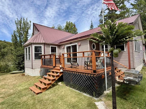
Charming Lakeside Retreat on Pristine Maidstone Lake! Escape to tranquility with this enchanting 2-bedroom, 2-bathroom home nestled on the picturesque shores of Maidstone Lake. This year-round haven features a spacious open-concept living area adorned with natural woodwork, including knotty pine walls and wide pine board flooring and breathtaking lake views through a stunning wall of windows. Step out onto your new deck, perfect for morning coffee or sunset gatherings, and enjoy 146 feet of private lake frontage complete with two docks. The primary bedroom offers direct access to a full bath and laundry room, while an additional bedroom and a stylish 3/4 bathroom complete the main level. Need extra space? The versatile attic area can serve as a cozy bunk room or ample storage. Outside, the level lawn is ideal for outdoor activities, featuring a charming firepit area for evening relaxation. A detached 2-bay garage with additional storage ensures all your needs are met. Recent upgrades include a new propane heating system, cable for Starlink Internet, a new dock, a whole house generator, and an extended driveway. This property is more than just a home; it's a lifestyle. Embrace the serene lakeside living you've always dreamed of! Don't miss your chance to experience the beauty and tranquility of year-round living on Maidstone Lake.
Copyright © 2026 PrimeMLS. All rights reserved. All information provided by the listing agent/broker is deemed reliable but is not guaranteed and should be independently verified.

12/16/2025
$699,000
60.88 ac.
ACTIVE
Essex County - 1733 Vermont 105, Brighton, VT
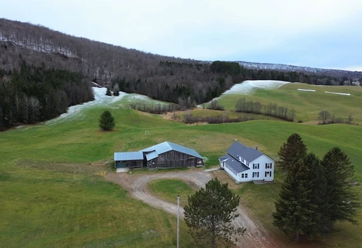
Experience the best of Vermont s Northeast Kingdom at this beautifully renovated 6-bedroom, 2-bath farmhouse set on 60+ picturesque acres in Brighton. The property offers 20+ acres of open fields and 40+ wooded acres with trails throughout, perfect for outdoor enthusiasts. Enjoy direct VASA ATV trail access, VAST snowmobile trail access, and several lakes just minutes away. Combining rustic charm with modern comfort, the home features over 2,500 sq. ft. of living space, including a fully renovated kitchen with granite countertops, an open living/dining area, two full baths, laundry, a comfortable den with exposed beam, propane stove, and wet bar, and a spacious main level bedroom. Upstairs, five well-appointed bedrooms provide plenty of space for family and guests. The recently built three-season porch showcases tongue-and-groove pine, wide-plank floors, and tranquil country views. Outside, a 70 x40 barn offers exceptional storage or workshop potential, and the attached heated 28 x28 garage is ideal for vehicles, snowmobiles, or ATVs. Modern systems include oil-fired baseboard heat, a wood furnace, metal roof, drilled well, and private septic. New Ascent combi-boiler installed in 2026. A true Vermont property ideal for use as a year-round home or a four-season recreational retreat.


1

