
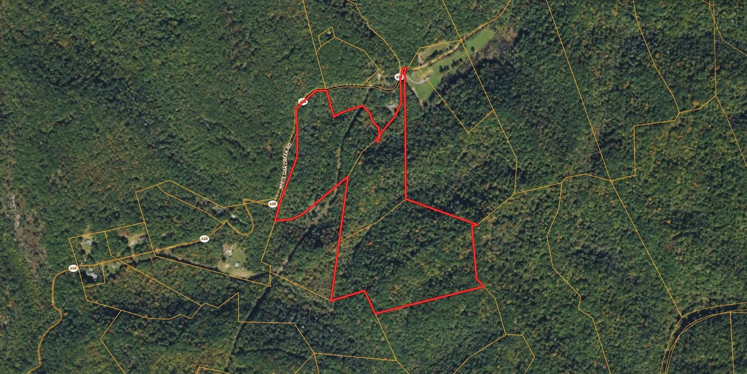
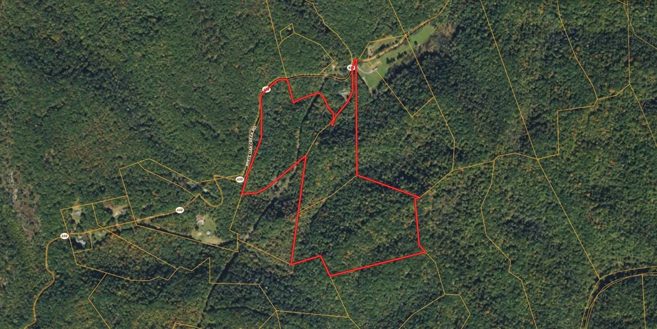
49 Acres For Sale Near National Forest in Wise County Virginia!
White Oak Creek Rd, Pound, VA | Lat/Lng: 37.1725, -82.5644
$65,000
49 ac.
05/15/2026
ACTIVE
Description
Interested in this property? Call, text, or email us today for more details!
(540) 824-3372
Feel free to visit the property any time, no need to set up an appointment, this property has no address.
Subscribe to email alerts by texting your e-mail address to (541) 375-0012 and be the first to know when we get a great deal in
By texting (541) 375-0012 you authorize Country Land Group to send text messages with offers & other information, possibly using automated technology, to the number you provided. Message/data rates apply. Consent is not a condition of purchase. You may unsubscribe at any time.
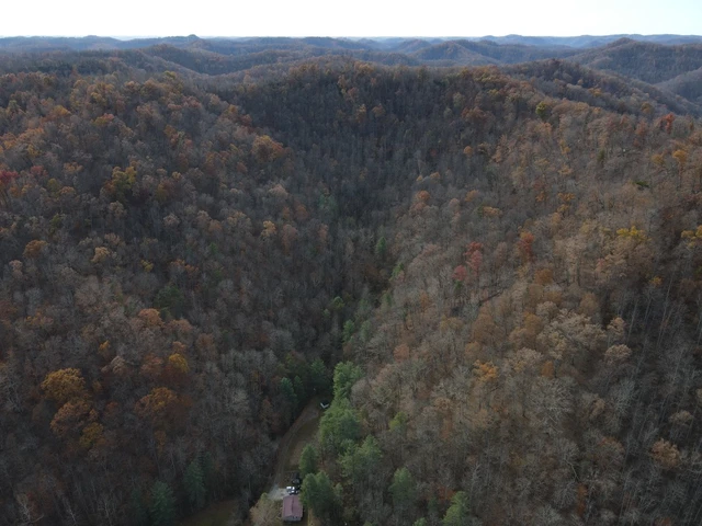
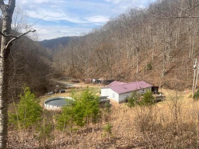
Escape to the mountains on White Oak Creek Road in the heart of Southwest Virginia. Zoned Agricultural–Rural Residential, this versatile property offers endless possibilities with no HOA and no deed restrictions. Public water is available, electricity is at the road, and only a septic system is needed to start building your dream cabin, homestead, vacation retreat, or investment property. The land can also be subdivided for added flexibility and future value.
Enjoy privacy, scenic mountain views, and outdoor adventure with Jefferson National Forest located directly across the street. Conveniently located near Pound, Wise, and Appalachia for everyday essentials, and less than an hour from Pikeville, Kentucky for shopping, dining, and entertainment. Don’t miss this rare opportunity to own mountain land with utilities nearby and room to grow.
Address: White Oak Creek Rd, Pound, VA, 24279
Cash Discount Price: $65,000.00
*There is a $1000 deposit required with all purchases. $500 is a non refundable transaction fee and the remaining $500 would be applied to the purchase price at time of closing.
Owner Financed Price: $65,000.00
Owner Financing Terms: $26,000.00 down and $1,043.96/month for 48 months.
*Applicable fees may apply including but not limited to $35/ month servicing fee and 12.9% interest for owner financing. Buyer is responsible for annual property tax. Contact Country Land Sellers for more details. Monthly payment subject to change based on down payment. Monthly payment shown is an estimate only.
County: Wise
Acres: 49 Acres (Raw Land)
Coordinates: 37.1725, -82.5644
Parcel #: 002376, 002377 and 002378
Yearly Estimated Taxes: $169.05
Elevation: 1733 FT
Property Dimensions: L: 2102.77 FT; W: 699.83 FT
Zoning: Agricultural-Rural Residential
Does this property have an HOA?: No
Does this property have a survey?: No
Elementary school: J.W. Adams Combined
Middle school: L.F. Addington Middle School
High school: Central High School
Phone # for electric company: Appalachian Power Company (800) 956-4237
Legal Description: White Oak Crk. 2.00 Ac.
and
White Oak Crk. 7.00 Ac
and
Pine Mtn.(M.D. Co.) 40.00 Ac
If this property is not what you are looking for, go to our website and sign up for our deal alerts; you will be notified whenever we have a new property for sale! Or, e-mail, call or text us, and we may be able to find the property you are looking for.
Details
County: Wise
Zipcode: 24279
Property Type One: Recreational Property
Property Type Two: Residential Property
Property Type Three: Undeveloped Land
Brokerage: Country Land Sellers
Brokerage Link: countrylandsellers.com

Luke Harris
Country Land Sellers
(540) 824-3372
By clicking the button, you agree to our Terms of Use and Privacy Policy.


Nearby Listings
Floyd County, KY
$199,000 - 192 ac.
Lee County, VA

$299,900 - 188 ac.
Lee County, VA
$179,900 - 120 ac.
Washington County, VA

$274,900 - 89 ac.
Wise County, VA

$764,500 - 1 ac.
Lee County, VA

$795,000 - 3 ac.
Lee County, VA
$595,000 - 2 ac.
Lee County, VA
$749,000 - 45 ac.
Russell County, VA

$179,999 - 3 ac.
Pike County, KY
$250,000 - 170 ac.