

SMITHERS COMMERCIAL
Rt. 60 at Montgomery Exit, Smithers, WV | Lat/Lng: 38.1832, -81.3121
$150,000
3.74 ac.
08/13/2026
ACTIVE
Description
OVERVIEW
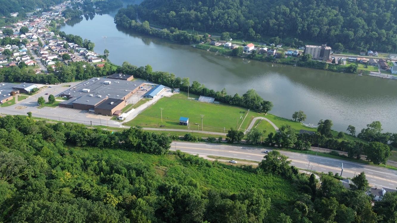
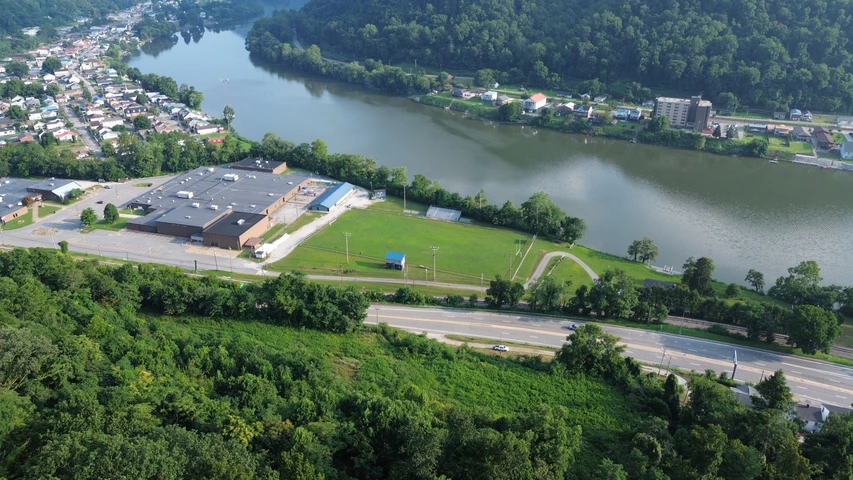
Smithers-Commercial is a 3.74-acre commercial tract of land located in scenic Fayette County, West Virginia. Home to the New River Gorge National Park and Preserve, Fayette County offers exceptional recreational and business opportunities. Specifically located in Smithers, West Virginia, this property offers a strategic development location with high visibility overlooking the mighty Kanawha River. The property is ready for unique commercial development with essential utilities available roadside. Smithers Commercial is an opportunity to acquire a versatile commercial property in a flourishing area not far from the state capital of Charleston, West Virginia.
HIGHLIGHTS
*3.74-acres prime development land overlooking the Kanawha River
*Unrivaled visibility with frontage along U. S. Route 60
*Located in the heart of the Kanawha Valley
*A unique investment opportunity with heavy growth potential
*Profit from remarkable accessibility and proximity to key destinations
*Zoned by the City of Smithers as a Conservation District
*Potential uses include, but are not limited to, campground development, boat livery, marina, public recreation facility, park, welcome center and much more.
*Appalachian Outlaws ATV/dirt bike riding trail currently being developed in nearby Cedar Grove, WV
*Potential ancillary business site for the nearby Appalachian Outlaws Trail system
*Current utilities include: water, electric, and a modern technology infrastructure
WATER
Smithers-Commercial is located across U. S. Route 60 from the great Kanawha River. The Kanawha River is a tributary of the Ohio River and is approximately 97 miles long. The largest inland waterway in West Virginia, its watershed has been a significant industrial region of the state since early in the 19th century.
MINERAL RESOURCES
West Virginia is one of the states in the United States that has two separate ownership titles; those being surface right and mineral rights. All rights the owner has will convey with the property. A mineral title search could be conducted by a title attorney at the same time when the surface title search is being conducted.
BOUNDARIES AND SURVEY
The property was surveyed by Ghosh Engineers, Inc in August 1996. A plat of that survey is recorded as in the Office of the County Clerk of Fayette County in Map Cabinet 1 Slide 118. A metes-and-bounds description from that survey is contained in the owner’s deed. The property is being sold by the boundary and not by the acre.
UTILITIES
Water: Public
Sewer: Public
Electricity: Yes
Telephone: Yes
Internet: Yes
Cellphone Coverage: Good
ACCESS/FRONTAGE
The property has direct road frontage to U. S. Route 60.
ZONING
The City of Smithers has zoning and subdivision regulations. According to City information, this property is zoned as Conservation District with defined commercial uses. All prospective buyers should consult the City Government and also the Health Department for details regarding zoning, building codes, and installation of water wells and septic systems.
Variance requests for additional uses may be filed and heard before the City of Smithers Board of Zoning Appeals.
DEED and TAX INFORMATION
Deed Information: DB 564 Pg. 439
Fayette County, West Virginia
Acreage: 3.74 acres +/-
Real Estate Tax ID/Taxes:
Fayette County, West Virginia
Smithers Corporation (11)
Tax Map 6 Parcel 7; Class 4
2026 Real Estate Taxes: $1363.08
SURROUNDING AREA
APPALACHIAN OUTLAWS TRAIL (AOT)
From beginner-friendly loops to hardcore climbs, Appalachian Outlaw Trails is designed to deliver adrenaline, freedom, and jaw-dropping mountain scenery across every mile. Nestled in the stunning Upper Kanawha Valley, the long-term goal of this trail system looks to span over 100,000 acres of wild, rugged terrain.
CHARLESTON, WV
Charleston is the capital and most populous city of the State of West Virginia. Located at the confluence of the Elk and Kanawha rivers, it is the county seat of Kanawha County. The population was 48,864 at the 2020 census. The Charleston metropolitan area has approximately 203,000 residents. Charleston is the cultural, recreational and business capital of the Kanawha Valley.
Charleston was established in the late 18th century and formally incorporated in 1794, with the trustees being Daniel Boone, Leonard Morris, and William Morris. The city gained prominence in the 19th century with the growth of the salt industry and later expanded due to coal mining. After West Virginia separated from Virginia, Charleston became the permanent state capital in 1885. Its economy and infrastructure further evolved in the 20th century with the rise of chemical manufacturing and public sector employment.
Charleston is the home of the Charleston Dirty Birds of the Atlantic League of Professional Baseball and the annual 15-mile (24 km) Charleston Distance Run. Yeager Airport and the University of Charleston are in the city. West Virginia State University is in the area, as are West Virginia University and Marshall University satellite campuses.
FAYETTEVILLE, WV
Fayetteville, West Virginia, with a population of just below 3,000, was listed as one of the 2006 “Top 10 Coolest Small Towns in America” by Budget Travel Magazine and as “Best River Town 2013” by Blue Ridge Outdoors magazine. Fayetteville’s historic district is both charming and one of the most attractive locations for outfitters shops, boutique shops, and specialty restaurants in West Virginia. More than a dozen antiques shops were operating in the Fayetteville area in summer 2017, and five independent restaurants in the district were offering an outstanding selection of unique cuisine.
OAK HILL, WV
Oak Hill is Fayette County’s largest municipality with a population of just over 8,000 residents. Known as a gateway to the New River Gorge National Park and Preserve, Oak Hill is a hub for outdoor adventures such as whitewater rafting, hiking and rock climbing. Oak Hill also offers a charming Appalachian small-town vibe with local shops and history. Its proximity to America’s 63rd National Park makes it a prime base for exploring the area’s natural beauty.
NEW RIVER GORGE NATIONAL PARK AND PRESERVE – AMERICA’S NEWEST NATIONAL PARK!
One of the most exciting destinations for hiking, biking, climbing, and paddling in the eastern United States, the New River Gorge National Park and Preserve was established by the National Park Service in 1978 and includes more than 80,000 acres in and adjacent to the New River Gorge and the valley of the New River. More than a million visitors annually climb rocks along the rim of the gorge near Fayetteville and paddle its whitewater runs on the New River and its tributaries. Countless miles of hiking and biking trails wander the park and climb into the surrounding mountains. The nearby Gauley River National Recreation Area likewise attracts thousands of tourists annually, notably rafters during “Gauley Season” in autumn when the river runs strong.
NEW RIVER
The New River is shared by boaters, fisherman, campers, park visitors, and local neighbors. The New River is recognized as the “second oldest river in the world” and is estimated to be between 10 and 360 million years old. Its headwaters begin near Blowing Rock, NC and is one of the few rivers in North America that flows northerly.
Class I, II, III, IV and V rapids dot the entire 320 miles of New River making it a great paddling, tubing, and white-water rafting adventure. Beautiful cliffs, bluffs, and mountain views make it one of the most scenic rivers on the east coast.
New River Gorge National River includes 53 miles of free-flowing New River, beginning at Bluestone Dam and ending at Hawks Nest Lake. The New River typifies big West Virginia style whitewater. Within the park it has two very different characters. The upper (southern) part of the river consists primarily of long pools, and relatively easy rapids up to Class III. It is a big powerful river, but very beautiful, always runnable, and providing excellent fishing and camping. There are multiple river access points, and trips can run from several hours to several days.
The lower (northern) section of river is often referred to as “the Lower Gorge.” In a state that is justifiably renowned for colossal rapids, the Lower Gorge has some of the biggest of the big with rapids ranging in difficulty from Class III to Class V. The rapids are imposing and forceful, many of them obstructed by large boulders which necessitate maneuvering in very powerful currents, crosscurrents, and hydraulics. Some rapids contain hazardous undercut rocks.
Fast water, big rocks, and lazy/slow stretches are features of the New River. Water sports enthusiasts will find the New River ideal for swimming, canoeing, fishing, kayaking, tubing, snorkeling, paddle boarding and windsurfing. Great fishing is found in the New River with bass (largemouth, smallmouth, and rock), flathead catfish, channel catfish, muskie, walleye and bluegill present in good numbers.
Details
County: Fayette
Zipcode: 25186
Brokerage: FoxFire Realty
Brokerage Link: www.foxfirenation.com
Apn: 11 300070000

Richard Grist
FoxFire Realty
(304) 645-7674
By clicking the button, you agree to our Terms of Use and Privacy Policy.


Nearby Listings
Fayette County, WV
$975,000 - 153 ac.
Fayette County, WV
$179,000 - 14 ac.
Fayette County, WV
$600,000 - 90 ac.
Braxton County, WV
$375,000 - 163 ac.
Fayette County, WV
$592,500 - 13 ac.
Fayette County, WV

$5,000,000 - 13 ac.
Fayette County, WV
$1,800,000 - 23 ac.
Raleigh County, WV
$199,000 - 1 ac.
Kanawha County, WV
Auction - 64 ac.
Kanawha County, WV
Auction - 54 ac.