
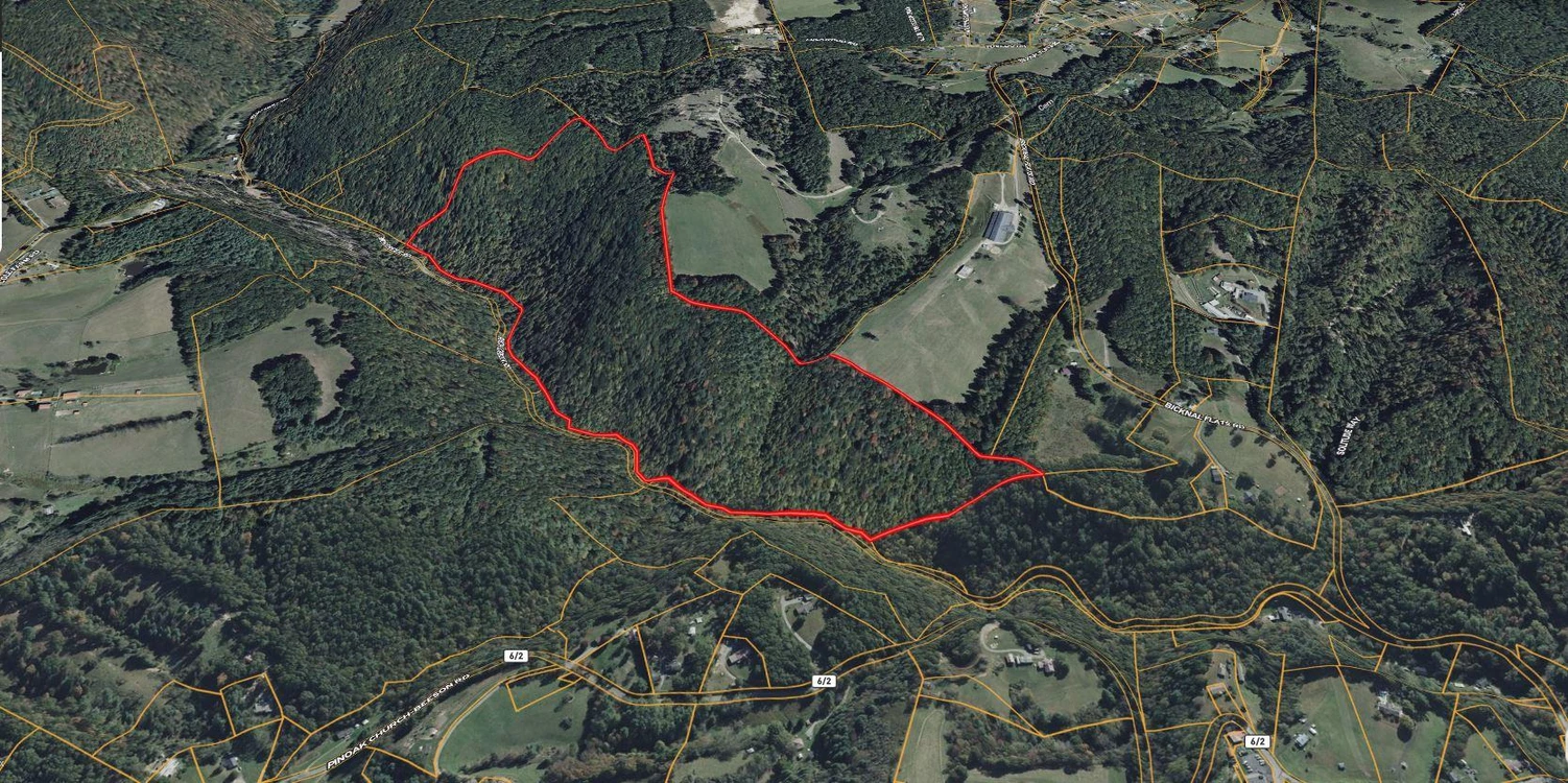
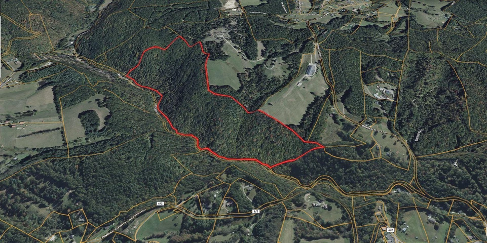
60 Acres For Sale in Mercer County West Virginia!
Richcreek, Rock, WV,, Rock, WV | Lat/Lng: 37.4428, -81.1882
$129,900
60 ac.
07/23/2025
ACTIVE
Description
Interested in this property? Call, text, or email us today for more details!
(540) 824-3372
Feel free to visit the property any time, no need to set up an appointment, this property has no address.
Subscribe to email alerts by texting your e-mail address to (541) 375-0012 and be the first to know when we get a great deal in.
By texting (541) 375-0012 you authorize Country Land Group to send text messages with offers & other information, possibly using automated technology, to the number you provided. Message/data rates apply. Consent is not a condition of purchase. You may unsubscribe at any time.
Versatile property with access from Rich Creek Rd and no zoning, HOA, or deed restrictionsideal for building or investment. City water is available, septic needed, and electricity can be accessed from nearby homes. The land is sub-dividable with no minimum lot size. A creek crosses the entrance, and a small portion lies within a flood zone.
Just 10 minutes to Kegley for basic amenities and the unique Lake Shawnee Haunted Amusement Park. Only 20 minutes to Princeton for expanded options including parks, museums, the Elks Lodge Golf Course, and boating at the Dan Hale Reservoir. A scenic, flexible opportunity with loads of potential!
No need to schedule a showing - Go and Show!
Buyer to verify all of the above!
Address: Richcreek, Rock, WV, 24747
Cash Discount Price: $129,900.00
*There is a $1000 deposit required with all purchases. $500 is a non refundable transaction fee and the remaining $500 would be applied to the purchase price at time of closing.
Owner Financed Price: $129,900.00
Owner Financing Terms: $51,900.00 down and $2,088.68/month for 48 months.
*Applicable fees may apply including but not limited to $35/ month servicing fee and 12.9% interest for owner financing. Buyer is responsible for annual property tax. Contact Country Land Sellers for more details. Monthly payment subject to change based on down payment. Monthly payment shown is an estimate only.
County: Mercer
Acres: 60 Acres (Raw Land)
Coordinates: 37.44278, -81.18821
Parcel #: 11-24-01110000
Yearly Estimated Taxes: $596.46
Elevation: 2620 FT
Property Dimensions: L: 4272.04 FT; W: 1210.33 FT
Zoning: No zoning
County Planning and zoning phone #: No Planning and Zoning Department.
Does this property have an HOA?: No
Does this property have a survey?: No
Elementary School: Lashmeet/Matoaka Elementary School
Middle School: Pikeview Middle School
High School: Pikeview High School
Phone # for electric company: Appalachian Power Company (800) 956-4237
Legal Description: TBD
If this property is not what you are looking for, go to our website and sign up for our deal alerts; you will be notified whenever we have a new property for sale! Or, e-mail, call or text us, and we may be able to find the property you are looking for.
Details
County: Mercer
Zipcode: 24747
Property Type One: Recreational Property
Property Type Two: Undeveloped Land
Brokerage: Country Land Sellers
Brokerage Link: countrylandsellers.com

Luke Harris
Country Land Sellers
(540) 824-3372
By clicking the button, you agree to our Terms of Use and Privacy Policy.


Nearby Listings
Raleigh County, WV

$595,000 - 60 ac.
Summers County, WV

$885,000 - 64 ac.
Raleigh County, WV
$2,600,000 - 408 ac.
Greenbrier County, WV

$170,000 - 0 ac.
Summers County, WV

$650,000 - 80 ac.
Giles County, VA

$1,200,000 - 154 ac.
Bland County, VA
$639,000 - 48 ac.
Greenbrier County, WV

$295,000 - 40 ac.
Bland County, VA

$239,900 - 195 ac.
Pulaski County, VA

$597,500 - 239 ac.