
Build or Hold in One of Minnesota’s Most Accessible Lake Regions
Ode Cir, Browerville, MN | Lat/Lng: 46.1945, -94.7933
$11,979
0.49 ac.
05/06/2026
ACTIVE

Description
Minnesota lake country has a pull that is hard to explain until you have experienced it.
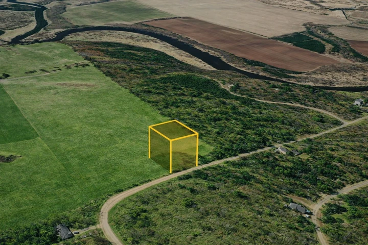
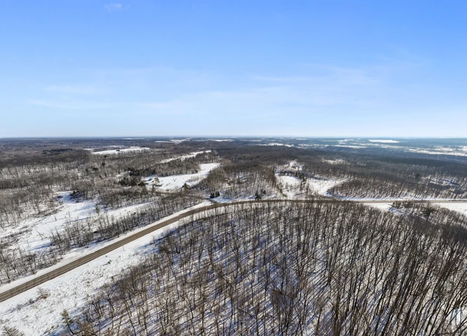
This nearly half-acre lot on Ode Circle in the Prairie River Heights Subdivision in Todd County puts you right in the middle of it, with four lakes practically in your backyard. Fawn Lake, Turtle Lake, Pine Island Lake, and Little Pine Lake are all just minutes away, making every season here a reason to get outside, whether you are casting a line in the summer, watching the leaves turn in the fall, or ice fishing when the Minnesota winter settles in.
The lot is level, flood-free, and situated at 1,300 feet of elevation with a clean 120' x 177' footprint. Power is provided by the Todd-Wadena Electric Co-Op, and the lot is zoned single-family residential with a modest 600 sq ft minimum build requirement. At just $18 per year in property taxes, the cost of ownership here is about as close to free as land gets.
As part of the Sylvan Shores community, the $120/year POA unlocks a genuinely impressive set of amenities: a private clubhouse, swimming pool, campground, exclusive boat landings, a lakeside beach and fishing dock, canoe and paddleboard access, multiple lake and river access points, and peaceful walking paths winding through the lake country landscape. It is the kind of community that makes neighbors out of strangers and keeps people coming back summer after summer.
St. Cloud is about 64 miles south when you need city conveniences, and the charming small town of Browerville is just over 11 miles away for everyday essentials.
At $11,200 cash or $240/month with no credit check, this is Minnesota lake country living at a price that is almost too good to pass up.
PROPERTY DETAILS
APN: 19-0071000
Size: 0.49 Acres
County: Todd
State: Minnesota
Terrain: Level
Elevation: 1300'
ENVIRONMENTAL FACTORS
Fire Risk: Moderate (5/10)
Flood Risk: Minimal (1/10)
Heat Risk: Minimal (2/10)
Wind Risk: Minimal (1/10)
Sources:
Fire -- USFS Wildfire Hazard Potential
Flood -- FEMA National Flood Hazard Layer
Heat -- NOAA Climate Normals
Wind -- NOAA HURDAT
GPS COORDINATES
GPS Center: 46.1945227, -94.7932627
Details
County: Todd
Zipcode: 56438
Property Type One: Undeveloped Land
Brokerage: GatewayLandInvestments.com
Brokerage Link: https://parcelview3d.com/portfolio-view/?customer=1
Apn: 190071000

Gateway LLC
GatewayLandInvestments.com
(320) 301-7957
By clicking the button, you agree to our Terms of Use and Privacy Policy.


Nearby Listings
Cass County, MN

$824,900 - 86 ac.
Morrison County, MN
$995,654 - 1 ac.
Todd County, MN
$1,500,000 - 40 ac.
Todd County, MN

$3,200,000 - 615 ac.
Wadena County, MN
$649,900 - 240 ac.
Otter Tail County, MN

$300,000 - 10 ac.
Todd County, MN
$11,500 - 0 ac.
Todd County, MN
$11,500 - 0 ac.
Wadena County, MN
$145,000 - 40 ac.
Morrison County, MN
$639,900 - 98 ac.