
THE RICHLANDS 338
Midland Trail East, Lewisburg, WV | Lat/Lng: 37.8651, -80.5069
$895,000
338 ac.
05/19/2025
ACTIVE


Description
OVERVIEW
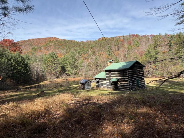
The Richlands 338 is a well-rounded property that highlights much of what makes southeastern West Virginia special: rugged scenery, clear and cold rivers, endless outdoor recreation, and an agreeable four-season mountain climate. Convenient access to the historic town of Lewisburg and the amenities of the Greenbrier Resort balance this mountaintop forests privacy and rural character, making it an accessible retreat with broad appeal.
HIGHLIGHTS
338+/- contiguous acres - multi-use, timber, recreational, and residential
Richlands 338 is in the heart of a biological, historic, and recreational mecca
First time on the market for nearly a century
Five minutes to Historic Lewisburg and small city amenities
Wildlife Habitat Improvement Harvest conducted in 2022
Diverse and abundant residential wildlife population
Four season climate
Near total darkness and minimal noise pollution
Cultural & educational opportunities throughout the region
Seven miles of interior roads and trails (See Maps & Documents for map of interior roads)
Shooting sports, ATV- horseback riding, hiking, camping, hunting, nature viewing
Suitable for residential or cabin development
Elevations range from 1979 ft. to 2325 ft.
Low taxes, low population density
Jet airports - Blacksburg, Pittsburgh, Charleston, Lewisburg, Charlotte
Can create a lasting generational legacy
OWNER'S NARRATIVE
100-YEAR HISTORY OF THE GILBERT GREENBRIER PROPERTY
Dr. Lewis D. Gilbert
May 3, 2025
In 1921, our grandfather, Lewis Neuman Gilbert, ("Poppaw Gilbert"), a logger, blacksmith and coal miner from Ronceverte, WV, purchased the original 170-acre tract of land in Greenbrier County with the apparent notion that the property was very close to the Organ Caves/Lost Caverns. Folklore was that these caves still held hidden Civil War treasures of GOLD left there by the Confederates when Confederate paper money was no longer being accepted as legal tender and subsequently hidden there from the Union soldiers to be later recovered. The Gold was never found. Nevertheless, forty years went by and in the 1960's, the US Federal Interstate Highway system came through Greenbrier County, cutting the right of way of this property away from the Organ Caves/Lost Caverns connection. The property was rich in wildlife, big game, as well as huge American Chestnut trees that were 3 to 4 feet in diameter. (It was later discovered in the early 60's the Chestnut trees were cut down and "stolen" from the property!)
In 1962, Lewis Neuman Gilbert passed away leaving his three sons- WF "Pete" Gilbert, Arthur "Arch" L Gilbert, and Jack "Jack" D Gilbert, Sr., the original 170 acres property. In the mid 1960s, the Gilbert brothers were approached by a lumberman to timber the property. In doing so, the lumberman not only paid them for the lumber, but he also agreed to obtain and transfer a Right of Way to Route 60 (now the gate entrance) and bought and transferred an additional 168+ acres to the Gilbert brothers, that now represents the existing 338.58 acres of the Gilbert Property. The lumberman also created/improved the now existing hunting access/logging roads. Since the 1960s the property has been primarily used for family game hunting and ATV recreation/camping.
In 2009, Arthur L. Gilbert passed away, leaving his 1/3 of the Property to his son, Dr. Lewis D. Gilbert. In 2012, WF Pete Gilbert passed away and left his 1/3 to his surviving brother, Jack D Gilbert, Sr. The current owners of the Property are Jack D Gilbert, Sr. 2/3 and Dr. Lewis D Gilbert 1/3. Approximately five years ago, a carefully selected harvest of timber was conducted by Certified Foresters to enhance grassland areas for the benefit of upland game and the deer population. Timbered areas were reseeded with quality grasses to restore the grasslands. The logging roads were also improved to gain better access to the far regions of the property from the Route 60 gate entrance. As Mother Nature continues to enhance the property, it is a choice setting for a rustic or log cabin residence, camping sanctuary, Air B&B or wildlife meeting center. Located only minutes from 1-64, and 10 minutes from Lewisburg town center.
History compiled by Jack D Gilbert, Sr; Cathy Gilbert Barnes-daughter of Jack D Gilbert, Sr; Jack D Gilbert Il- son of Jack D Gilbert, Sr; and Dr. Lewis D. Gilbert-son of Arthur L Gilbert (deceased)
LOCATION
Google Coordinates: 37.871082(N), -80.501245(W)
Address: Midland Trail East, Lewisburg, WV 24901. No 911 address is assigned to property without structures.
Elevation Range: 1979 ft. to 2325 ft. +/-
Drive Times (approximate)
Local Towns
I-64 Lewisburg Ronceverte Exit 169: 15 minutes
Beckley: 35 minutes
Charleston: 1 hour 45 minutes
Lewisburg (main town): 10 minutes
Union: 40 minutes
White Sulphur Springs and The Greenbrier Resort: 25 minutes
Airports
Greenbrier Valley Airport, Lewisburg: 20 minutes (Jet service)
Raleigh County Memorial Airport, Beckley: 45 minutes
Roanoke-Blacksburg Regional Airport, Roanoke, VA: 1 hour 45 minutes
West Virginia International Yeager Airport, Charleston: 1 hour 45 minutes
Medical
Greenbrier Valley Medical Center, Fairlea: 15 minutes
Roanoke Valley Medical Center: 2 hours
University of Virginia: 2 hours
WVU Medical Center: 3 hours
Recreation
State Fair of West Virginia
Local Festivals Renaissance, Chocolate, Taste of our Town
Area Resorts The Greenbrier Resort, Glade Springs Resort, Warm Springs
Area Lakes Bluestone, Moomaw, Summersville, Anna
Snowshoe Ski Resort Winterplace Ski Resort
80,000-acre New River Gorge National Park and Preserve
1,000,000-acre Monongahela National Forest
1,800,000-acre George Washington & Jefferson National Forest
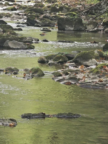
WATER
The headwaters of two separate dashed blue line intermittent streams are located on the property. The beginning of one stream is on the property for about one-fourth mile, and the beginning of the other stream is on the property for about one fourth mile. There should be some water flow in these streams, especially during rain events and snow melt. A beginning branch of Milligan Creek, a solid blue line stream, runs through the section of the property along US 60 for about 1/10 mile.
MINERAL RESOURCES
All rights the owner has in title will be conveyed with the property.
BOUNDARIES AND SURVEY
There are meets and bounds descriptions from previous surveys. The property is being sold by the boundary and not by the acre.
UTILITIES
Water: Well could be drilled or develop mountain springs
Sewer: A private system could be installed
Electricity: Roadside
Telephone: Roadside
Internet: Available through various carriers. Starlink satellite system works very well
Cellphone Coverage: Good to excellent
ACCESS/FRONTAGE
The property has frontage on US 60 for about 1/10 mile. The property road system connects directly to US 60.
ZONING
Greenbrier County is subject to some zoning and subdivision regulations. All prospective buyers should consult the County Commission and the Health Department for details regarding zoning, building codes and installation of septic systems.
PROPERTY TYPE/USE SUMMARY
The property has been used as all forestland and recreation.
(This summary is an estimation of current property use as determined from aerial photography. It is subject to the estimation of property boundaries and any errors in the interpretation of land use type from the aerial photography utilized.)
Details
County: Greenbrier
Zipcode: 24901
Property Type One: Recreational Property
Property Type Two: Residential Property
Property Type Three: Timberland
Brokerage: FoxFire Realty
Brokerage Link: www.foxfirenation.com

Richard Grist
FoxFire Realty
(304) 645-7674
By clicking the button, you agree to our Terms of Use and Privacy Policy.


Nearby Listings
Monroe County, WV
$365,000 - 82 ac.
Monroe County, WV

$279,900 - 97 ac.
Summers County, WV

$885,000 - 64 ac.
Raleigh County, WV
$2,600,000 - 408 ac.
Fayette County, WV

$3,650,000 - 811 ac.
Monroe County, WV

$1,795,000 - 29 ac.
Greenbrier County, WV
$699,000 - 49 ac.
Monroe County, WV
Auction - 319 ac.
Monroe County, WV
$495,000 - 134 ac.
Greenbrier County, WV
$240,000 - 1 ac.