Brogoitti Helix Dryland Farm
Hwy 331, Helix, OR | Lat/Lng: 45.8239, -118.6542
$1,152,468
320 ac.
05/04/2026
ACTIVE

Description
Brogoitti Helix Dryland Farm
Helix, Oregon
$ 1,152,468
Property:
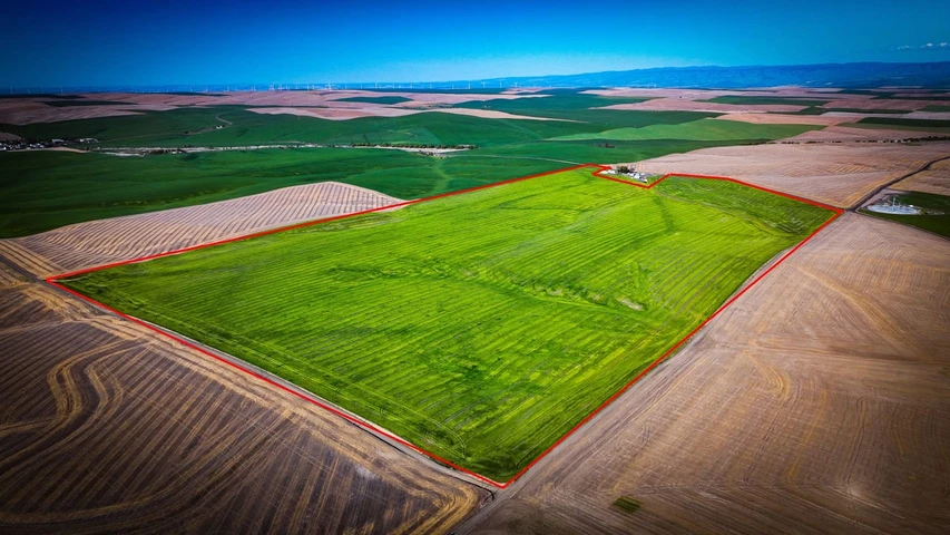
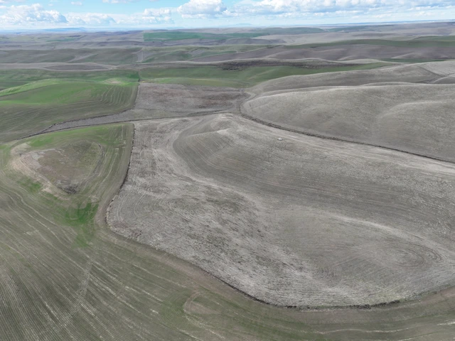
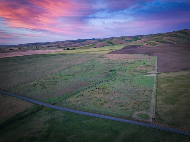
Located just outside of Helix, Oregon, this offering presents an opportunity to acquire approximately 320+/- acres of productive dryland farm ground in the heart of Umatilla County. Positioned in a well-regarded agricultural area with established farming history, the property is comprised primarily of cropland with gently rolling topography and an efficient field layout suited for continued dryland grain production.
This is a bare land offering, as the Seller will retain the existing home and all outbuildings, allowing the focus to remain solely on the income-producing farm ground. Final acreage will be determined upon completion of a survey, creating a clean separation between the homesite and the agricultural parcel.
Any sale is contingent upon Seller completing a partition, lot line adjustment, or other land division sufficient to separate the home and outbuildings into a separate parcel prior to closing. If this cannot be completed, Seller may terminate any transaction without liability.
Location:
The Brogoitti Helix Dryland Farm is situated in Umatilla County, OR, just 2+/- miles south of Helix, OR. The property is mapped as Tax Lot 4N3300-00-22000 and is accessed via county roads and/or from highway-335. Please refer to the aerial maps for specific entry points and layout.
Legal Identification of Subject Property:
Tax Lot 4N3300-00-22000
Parcel ID: 103774(Umatilla County)
Acreage Breakdown:
Total County Deeded Acres: 270.63
Tillable Acres: 320.13 (FSA Reported)
(Note: FSA acreages may exceed deeded acres due to programmatic inclusion of adjacent areas. Final Acreages to be determined from survey of partition.)
Leases:
2025-2026-The land is currently in a fallow rotation.
No known leases.
United States Department of Agriculture - Farm Service Agency:
Farm - 7482
Tract - 12373
Crop Ground:
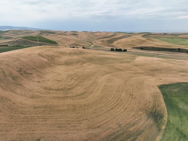
According to the FSA mapping, the property has a total of 320 +/- tillable production acres. Currently being farmed biennially as a wheat/fallow rotation, the 2025-2026 crop is in a fallow rotation. Sellers yield averages 70-85 B/U. Annual rainfall shows 12-17" +/- total precipitation for the area.
Soils:
The farm is dominated by Walla Walla silt loam soils, with approximately 71.5% consisting of 114B (1-7% slopes), complemented by additional Walla Walla silt loam variants across moderate slopes. These soils are well known throughout the region for their consistency and productivity in traditional dryland rotations, providing a dependable foundation for long-term agricultural performance.
Elevation ranges from approximately 1,760 to 1,860 feet above sea level.
Improvements:
Vacant land-No improvements.
Water:
No developed wells/springs or irrigation rights known.
Taxes:
- 2025 Tax Amount: TBD after partition
Topography:
The tilled portions of the property are flat to gently sloping farm ground, which is typical of the area.
Mineral Rights:
The owner does not warrant there are any mineral rights available. However, any mineral or geothermal rights owned by the seller are included as part of the property being offered for sale.
Zoning:
Property is zoned EFU, exclusive farm use. For complete zoning information, contact the Umatilla County Planning Department at 541-278-6252 .
152.055 DESCRIPTION AND PURPOSE.
The purposes of the EFU, Exclusive Farm Use Zone, are to preserve and maintain agricultural lands for farm use, including range and grazing uses, consistent with existing and future needs for agricultural products, forest and open spaces; to conserve and protect scenic resources; to maintain and improve the quality of air, water and land resources of the county and to establish criteria and standards for farm uses and related and supportive uses which are deemed appropriate. It is also the purpose of this use zone to provide the automatic farm use valuation for farms, which qualify under the provisions of ORS Chapter 308. The provisions in this use zone are subject to automatic legislative amendments as described in 152.004. (Ord. 2005=02, passed 1-5-2005)
Ownership & Title:
The property is currently held by Brogoitti Ranches INC
79308 Helix Hwy, Pendleton, OR 97801
Access:
The property can be accessed from highway-335 or Koebcke rd just 2+/- miles south of Helix, OR
Distances To Other Cities:
Helix, OR -2+/- Miles
Pendleton, OR -16+/- Miles
Walla Walla, WA -30 +/- Miles
Spokane, WA -182 +/- Miles
Boise, ID -230+/- Miles
Contact Information:
Whitney Land Company
101 SE 3rd St, Pendleton, OR 97801
(541) 278-4444
Disclaimer:
Information is deemed reliable but not guaranteed. Buyer to perform their own due diligence. CRP and FSA details provided from USDA forms and subject to verification.
Umatilla County:
Umatilla County was created on September 27, 1862, out of a portion of Wasco County. Umatilla is an Indian term meaning "rippling water" or "water rippling over sand" and has provided the name both for the county and its major river. Lewis and Clark and pioneers traveling the Oregon Trail passed through the area. The gold rush of 1862 brought miners and stock raisers to the mountains and grasslands of Umatilla County. The county expanded after the coming of the railroad in 1881 and the area was open to the development of dry land wheat farming. The fertile land of Umatilla County gives a strongly agricultural base to the county's economy. Fruit, grain, timber, cattle, and sheep are important agricultural products. Recreation, primarily in the Blue Mountains, and tourism, most notably for the annual Pendleton Round-Up rodeo, are also important to the local economy.
Details
County: Umatilla
Zipcode: 97801
Property Type One: Farms
Property Type Two: Undeveloped Land
Brokerage: The Whitney Land Company
Brokerage Link: https://land.com
Apn: 103774


Nearby Listings
Umatilla County, OR
$1,499,000 - 38 ac.
Walla Walla County, WA
$2,250,000 - 416 ac.
Walla Walla County, WA

$5,600,000 - 740 ac.
Umatilla County, OR

$274,000 - 68 ac.
Umatilla County, OR

$2,875,000 - 994 ac.
Umatilla County, OR
$1,200,000 - 144 ac.
Walla Walla County, WA
$239,000 - 160 ac.
Walla Walla County, WA
$100,000 - 30 ac.
Umatilla County, OR
$4,950,000 - 436 ac.
Umatilla County, OR
$300,000 - 73 ac.