
Waukeefriskee Wildlife Hideaway
Fort Gaines, GA | Lat/Lng: 31.6801, -84.9690
$1,919,000
582 ac.
08/20/2025
ACTIVE

Description
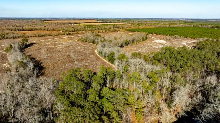
Property Overview
Discover your perfect retreat in Southwest Georgia, offering the perfect blend of investment, recreation, and homesite potential. With paved road frontage, power on-site, and a well-maintained internal road system, the tract features rolling terrain, hardwood bottoms, pine plantations, and recently harvested timberland ready for replanting or wildlife openings. Abundant deer, turkey, and small game make it a premier hunting property, while scenic ridge tops and plateaus provide ideal locations for a rural homestead or weekend retreat, all just minutes from Fort Gaines, Lake Walter F. George (Lake Eufaula), and regional amenities.
Location
Nestled in the heart of Southwest Georgia and the rolling hills of Clay County, the landscape around the property is dominated by timberland used for timber production and outdoor recreation. The quaint town of Fort Gaines is 9 miles southwest and is situated on the southern end of Lake Walter F. George (Lake Eufaula), which provides excellent boating and fishing opportunities. Bagby State Park is located just north of Fort Gaines, 12 miles from the property. The park offers great fishing and wildlife viewing from the shore or on the water by boat. It is also home to Meadow Links Golf Course, an 18-hole, 7,007-Yard, par-72 course that opened in 1998.
The town of Cuthbert is 15 miles northeast and is home to Andrew College. Eufaula, Alabama, is located 31 miles northwest of the property and offers lodging, restaurants, and shopping. Southwest Georgia is known for its excellent hunting and outdoor recreation opportunities. The region provides superior habitat for whitetail deer, eastern wild turkey, bobwhite quail, mourning dove, rabbit, and numerous other small game species. Highway 27 serves as a main corridor, connecting to major state highways: Georgia Highway 520 to the north and Georgia Highway 84 to the south. Dothan, Alabama, is 47 miles southwest and is a major community in the region, offering shopping outlets, a regional hospital, and Dothan Regional Airport. Columbus, Georgia, is 74 miles north of the property, home to Fort Benning, and offers whitewater rafting on the Chattahoochee River.
Access
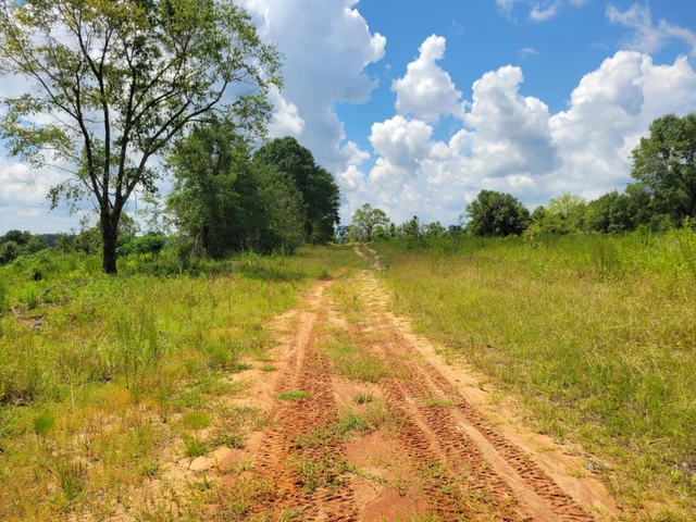
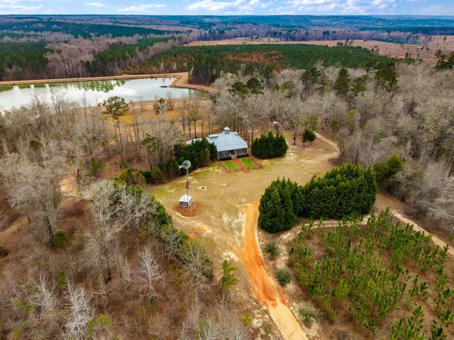
There are two entrance points to the property from Bethel Road, a paved county road, with approximately 2,325 feet of paved road frontage. The entrance on the northeast corner serves as the main access to the majority of the property and is the location of the power supply. This main road runs along the northern boundary before turning south to access the beautiful ridge tops and plateaus. Well-established interior roads, previously used for recreation and timber harvest, provide reliable all-weather access throughout the property. The second entrance is located in the central portion of the tract and provides access to a 55-acre area surrounded by creeks and streams.
Property Description
The elevation of the property ranges from 300 to 420 feet above sea level, with rolling terrain providing excellent views of the surrounding landscape. The soils are comprised of well-drained loamy sands, which are ideal for crop and timber production. There are exceptional flat plateaus that can be converted into food plots, wildlife openings, or agricultural fields. Several locations provide scenic views of the surrounding landscape and would be ideal for building a rural homestead or weekend getaway. Power is available on the property, providing electricity for a future homesite or retreat.
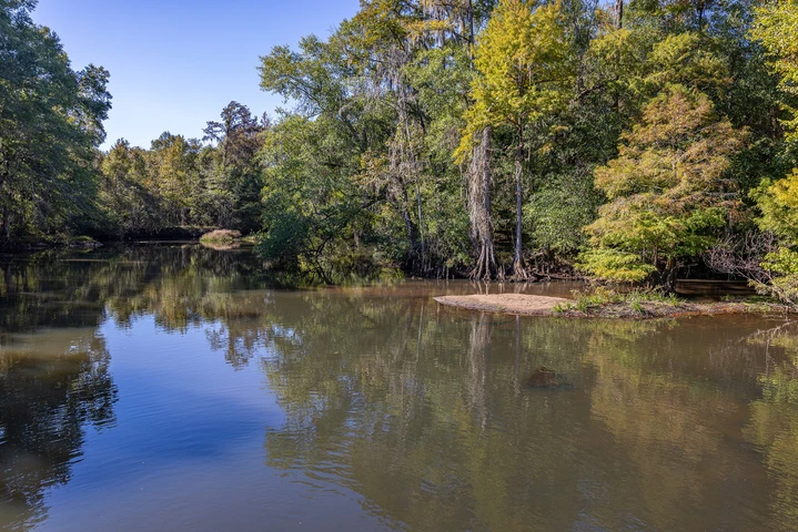
The varying forest cover offers an excellent mix of wildlife habitat for whitetail deer, eastern wild turkey, bobwhite quail, mourning dove, rabbit, and numerous other small game species. With over 300 acres of recently harvested timber areas, there are endless opportunities to create new wildlife openings and habitat. A well-established road system provides access to all areas of the property. The northeast corner of the tract fronts Waukeefriskee Creek, and several small tributaries or intermittent streams originate on the property, flowing into the creek just south of the boundary.
Timber Resource
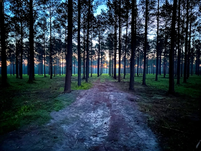
The timber component of the property consists of 132 acres of natural hardwood bottoms with a mixed species composition of oak, gum, hickory, and poplar; 92 acres of loblolly pine planted in 2020; 16 acres of longleaf pine planted in 2014; 1 acre of longleaf pine planted in 2018; 3 acres of food plots; 3 acres of roads; and 335 acres of open cut timberland. The natural hardwood bottoms are located along Waukeefriskee Creek and its small tributaries or intermittent streams, protecting these waterways while also providing excellent wildlife cover and browse.
The 2020 loblolly pine plantation will begin generating timber revenue from a first thinning in approximately 10 years. The two areas of longleaf pine will also be ready to thin around the same time. The 335 acres of recently harvested timberland present a clean slate. This area can be replanted for future timber revenue, or portions can be converted into wildlife openings, small agricultural fields, or dove fields.
Details
County: Clay
Zipcode: 39851
Property Type One: Recreational Property
Property Type Two: Timberland
Property Type Three: Hunting Land
Brokerage: Fountains Land
Brokerage Link: www.fountainsland.com
Apn: 032 018

Chad Hancock
Fountains Land
(229) 883-0505
By clicking the button, you agree to our Terms of Use and Privacy Policy.


Nearby Listings
Calhoun County, GA
$8,850,000 - 1442 ac.
Calhoun County, GA
$2,700,000 - 440 ac.
Webster County, GA

Auction - 310 ac.
Webster County, GA

Auction - 775 ac.
Webster County, GA

Auction - 443 ac.
Baker County, GA

$920,595 - 222 ac.
Barbour County, AL

$67,900 - 19 ac.
Randolph County, GA
$2,925,000 - 515 ac.
Clay County, GA

$827,500 - 238 ac.
Randolph County, GA
$344,000 - 106 ac.