
375+/- Acres For Sale | 2 Tracts | Merrick County, NE
Archer, NE | Lat/Lng: 41.2174, -98.1025
$2,723,150
375 ac.
12/01/2025
ACTIVE

Description
Total Listing Price: $2,723,150
Property Highlights
* 275 total acres offered in two adjacent tracts in Merrick County, Nebraska
* Turn-key irrigated farmland with extensive recent irrigation upgrades
* Strong water supply supported by multiple irrigation wells across both tracts
* Combination of center-pivot and limited gravity irrigation
* Underground irrigation piping added to improve efficiency
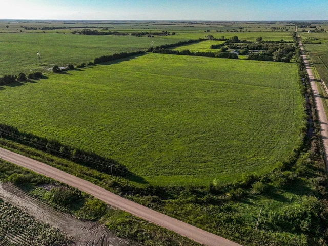
* Prairie Creek borders the south end of Tract 2, offering excellent wildlife and recreational value
* Opportunity to purchase tracts individually or together as a single, expanded operation
* Located in the Central Platte Natural Resources District
* All mineral rights owned by the seller, if any, convey to the buyer
Whether you are seeking to expand an established farming operation, consolidate irrigated acres, or invest in a well-maintained and productive Nebraska farm, this two-tract offering in Merrick County deserves careful consideration. These properties offer a rare combination of strong water resources, updated irrigation infrastructure, productive cropland, and recreational appeal. Tract 1 and Tract 2 are adjacent, allowing them to function seamlessly as a single unit, while also offering flexibility for buyers interested in individual tracts.
Together, the farms total approximately 275 acres and are priced at $2,723,150. Each tract has been thoughtfully improved and maintained, with significant investment made into irrigation systems, wells, and underground infrastructure to ensure reliable performance and long-term productivity.
Location and Area Overview
The properties are located in Merrick County, Nebraska, an area known for its highly productive soils, abundant water resources, and strong agricultural economy. Farms in this region benefit from access to multiple grain markets, a skilled agricultural workforce, and a long history of successful irrigated crop production.
Being situated within the Central Platte Natural Resources District provides additional confidence for buyers, as the district has a long-standing reputation for proactive water management and sustainable irrigation practices. This stability is an important consideration for operators and investors alike.
The proximity of Prairie Creek along Tract 2 enhances not only the agricultural diversity of the property but also its recreational appeal, particularly for buyers interested in hunting and outdoor activities.
Combined Acreage Summary
* Total Acres Offered: 275
* Total Listing Price: $2,723,150
* Tracts can be purchased together or individually
* Adjacent layout allows for efficient combined operation
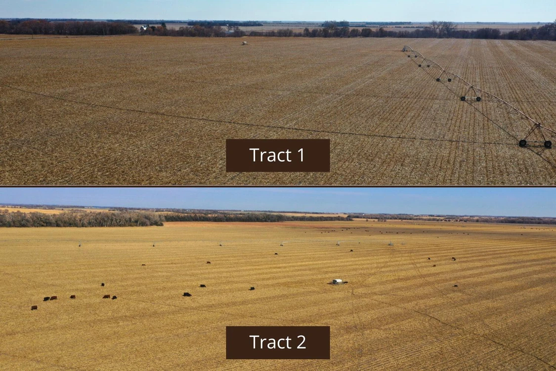
Tract 1 Overview
Tract 1 consists of approximately 119.75 acres and is priced at $886,150. This tract is well-suited for high-efficiency irrigated crop production and features a modern center pivot with a corner arm, maximizing irrigated coverage.
Legal Description
Part of the Northeast Quarter of Section 3, Township 14 North, Range 7 West, Merrick County, Nebraska
Acreage Breakdown for Tract 1
According to the county assessor, Tract 1 consists of 119.75 total acres, broken down as follows:
* Total Acres: 119.75
* Irrigated Acres: 110.48
* Grassland Acres: 6.41
* Other Acres: 2.86
The high percentage of irrigated acres makes this tract particularly attractive for row crop production, while the small amount of grassland provides additional flexibility.
Irrigation and Water Tract 1
Tract 1 is supported by an impressive total of five irrigation wells, providing redundancy and strong water availability. The wells include:
* Well G-106167, drilled in 1983, rated at 400 gallons per minute
* Well G-172737, drilled in 2014, rated at 150 gallons per minute, 38-foot pumping level, 40-foot well depth
* Well G-106168, drilled in 1983, rated at 400 gallons per minute
* Well G-013403, drilled in 1951, rated at 400 gallons per minute, 41-foot well depth
* Well G-111017, drilled in 2001, rated at 475 gallons per minute, 35-foot pumping level, 41-foot well depth
The tract includes a 2017 six-tower Valley center pivot equipped with a corner arm, allowing for efficient irrigation of irregular field corners and maximizing productive acres. Tract 1 is located in the Central Platte NRD and has 111.32 certified irrigated acres.
Soils and Productivity Tract 1
The soils across Tract 1 are well-suited for irrigated crop production and have supported consistent yields historically. With modern irrigation equipment and a reliable water supply, the tract is positioned to perform well under a variety of crop rotations and management strategies.
Property Taxes Tract 1
The 2025 property taxes for Tract 1 are $4,658.90, which is consistent with similar irrigated farmland in the area.
FSA Information Tract 1
The FSA information associated with this tract reflects strong base acres and yields, supporting long-term program participation and income stability:
* Total Cropland Acres: 343.58
* Corn: 292.53 base acres with a 117 PLC yield
* Soybeans: 31.41 base acres with a 42 PLC yield
* Total Base Acres: 323.94
Tract 2 Overview
Tract 2 is the larger of the two offerings, consisting of approximately 255.14 acres and priced at $1,837,000. This tract offers a diverse mix of irrigated cropland, limited dryland acres, grassland, and recreational features, including Prairie Creek along its southern boundary.
Legal Description
Part of the Southwest Quarter of Section 35, Township 15 North, Range 7 West, and part of the North Half of the Northwest Quarter and North Half of the Southwest Quarter, less 2.5 acres, of Section 2, Township 14 North, Range 7 West, Merrick County, Nebraska
Acreage Breakdown for Tract 2
According to the county assessor, Tract 2 consists of 255.14 total acres, broken down as follows:
* Total Acres: 255.14
* Irrigated Acres: 206.04
* Dryland Acres: 10.08
* Grassland Acres: 36.27
* Other Acres: 2.75
The combination of irrigated cropland and grassland provides both farming and recreational flexibility.
Irrigation and Water Tract 2
Tract 2 is supported by seven irrigation wells, several of which have been serviced, pulled, and repaired in recent years. An additional well was installed to further enhance water reliability. The wells include:
* Well G-076499A, drilled in 1993, rated at 75 gallons per minute
* Well G-102181, drilled in 1999, rated at 400 gallons per minute, 29-foot pumping level, 39-foot well depth
* Well G-104122, drilled in 1999, rated at 450 gallons per minute, 35-foot pumping level, 41-foot well depth
* Well G-0764991, drilled in 1993, rated at 75 gallons per minute
* Well G-101999, drilled in 1999, rated at 450 gallons per minute, 35-foot pumping level, 41-foot well depth
* Well G-195527, drilled in 1922, rated at 400 gallons per minute, 33-foot pumping level, 40-foot well depth
* Well G-102182, drilled in 1999, rated at 400 gallons per minute, 28-foot pumping level, 35-foot well depth
The irrigation equipment on Tract 2 includes a seven-tower Valley center pivot with a corner arm, set up for 1,000 gallons per minute and installed approximately four years ago, as well as a 2013 six-tower Valley center pivot set up for 425 gallons per minute. Underground piping has been added to improve water delivery efficiency and streamline irrigation operations.
Tract 2 is located in the Central Platte NRD and has 218.50 certified irrigated acres.
Recreational and Wildlife Potential
One of the standout features of Tract 2 is Prairie Creek, which borders the south end of the property. This natural corridor provides excellent wildlife habitat and contributes to strong trophy whitetail deer potential. The presence of year-round water, cover, and nearby food sources makes this tract appealing not only to farmers but also to buyers seeking recreational value.
Property Taxes Tract 2
The 2025 property taxes for Tract 2 are $9,410.56.
FSA Information Tract 2
The FSA information mirrors that of Tract 1, providing continuity and program benefits across the combined acreage:
* Total Cropland Acres: 343.58
* Corn: 292.53 base acres with a 117 PLC yield
* Soybeans: 31.41 base acres with a 42 PLC yield
* Total Base Acres: 323.94
Mineral Rights
All mineral rights owned by the seller, if any, will convey to the buyer at closing.
Conclusion
This 275 acre irrigated farm offering in Merrick County, Nebraska, represents a high-quality, turn-key opportunity with strong water resources, modern irrigation systems, and excellent long-term potential. The ability to purchase the tracts individually or together provides flexibility for a wide range of buyers, from expanding family operations to investors seeking dependable irrigated farmland.
With updated irrigation infrastructure, multiple wells, and the added recreational appeal of Prairie Creek, these properties stand out as a complete and versatile offering. Buyers seeking productive farmland with added lifestyle and investment benefits will find significant value in this exceptional Merrick County opportunity.
Details
County: Merrick
Zipcode: 68816
Property Type One: Farms
Property Type Two: Undeveloped Land
Brokerage: AgWest Land Brokers
Brokerage Link: www.agwestland.com

Jeff Moon
AgWest Land Brokers
(866) 995-8067
By clicking the button, you agree to our Terms of Use and Privacy Policy.


Nearby Listings
Merrick County, NE

$2,500,000 - 61 ac.
Nance County, NE

$995,980 - 289 ac.
Hall County, NE
$1,650,000 - 24 ac.
Merrick County, NE

$165,000 - 1 ac.
Nance County, NE

$499,000 - 77 ac.
Merrick County, NE
$500,000 - 46 ac.
Merrick County, NE

$165,000 - 1 ac.
Merrick County, NE

$140,000 - 1 ac.
Merrick County, NE

$2,000,000 - 425 ac.
Hamilton County, NE
$624,000 - 3 ac.