
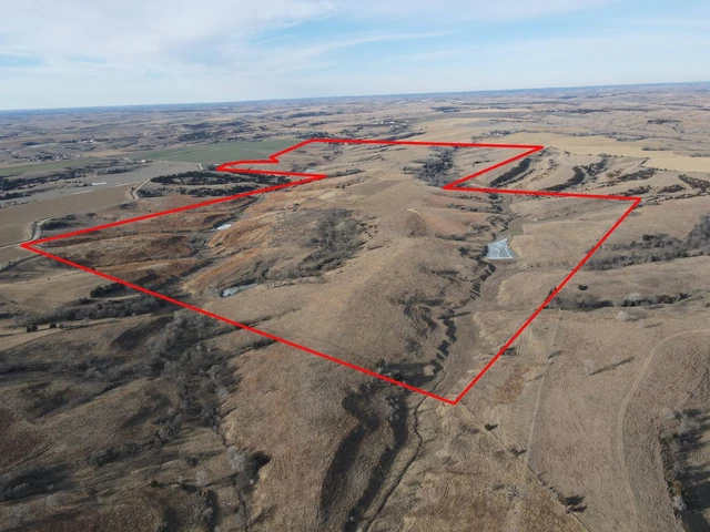
Major Land Auction - 1,112.76 Acres - 6 Tracts - Valley County, NE
47831 800th Road, North Loup, NE | Lat/Lng: 41.4236, -98.8991
Auction
1112.76 ac.
04/01/2026
ACTIVE

Description
Selling (6) pivot irrigated quarters plus 160 acres grassland & dryland. Located Southwest of North Loup in southern Valley County. A live auction with online-bidding available. Auction to be held in the Trotter Event Center in Ord.
Tract 1 - 160 Acres +/-
Location: Corner of 798 rd. and 480 rd. – 10 miles southwest of North Loup – next to the Valley/Sherman County line
Legal Description: Southeast Quarter of Section 36, Township 17 North, Range 14 West of the 6th P.M., Valley County, Nebraska
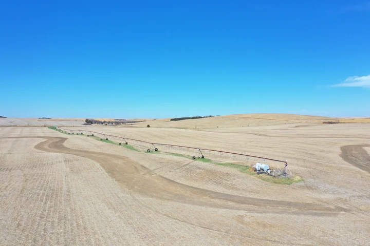
About the Land: 160 Acres, more or less, according to Valley County Assessor’s records. Pivot irrigated cropland including a Reinke 10 tower pivot system, an irrigation well and an electric stock well. Not included – irrigation well motor, geared, generator and control box.
Farm Service Agency: Corn base – 121.6 acres, Soybeans base – 18.2 acres, Wheat base – 6.1 acres, Grain Sorghum base – 3 acres
Natural Resources District: The land is located in the Lower Loup NRD and has certified irrigation rights for 133 acres.
Well Data: (per registration) G-041674, June 1969, 360ft. deep, 45ft. static water level, 125ft. pumping level, 1,050 GPM
2025 Taxes: (estimate) $4,789
Tract 2 - 160 Acres +/-
Location: Next to 799 rd. – directly northwest of Tract 1
Legal Description: Northwest Quarter of Section 36, Township 17 North, Range 14 West of the 6th P.M., Valley County, Nebraska
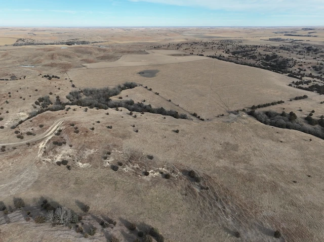
About the Land: 160 Acres, more or less, according to Valley County Assessor’s records. FSA shows 46.3 acres of tillable cropland, the remainder grassland. In the past water for livestock was provided by an electric well in the SE quarter.
Farm Service Agency: Corn base – 43.8 acres, Wheat base – 1.59 acres, Grain Sorghum base – 1 acre
2025 Taxes: (estimate) $1,836
Tract 3 - 160 Acres +/-
Location: Corner of 800 rd. and Round Barn ave. From North Loup 7 miles west on Hwy. 22 and 4 miles south on Round Barn ave. From Arcadia, 11 miles east.
Legal Description: Northwest Quarter of Section 26, Township 17 North, Range 14 West of the 6th P.M., Valley County, Nebraska
About the Land: 160 Acres, more or less, according to Valley County Assessor’s records. Pivot irrigated cropland including a Reinke 10 tower pivot system (new approx. 2011), electric irrigation well, Chief 17,000 bu. Grain bin and electric submersible well. Not included – cattle lot fences, guard rail, continuous panels, gates, irrigation well motor, pump & panel, discharge auger in the bin.
Farm Service Agency: (estimate) Corn base – 123 acres, Wheat base – 4.7 acres, Grain Sorghum base – 2.6 acres
Natural Resources District: The land is located in the Lower Loup NRD and has certified irrigation rights for approx. 114.5 acres.
Well Data: (per registration) G-041673, April 1974, 315ft. deep, 44ft. static water level, 135ft. pumping level, 800 GPM
2025 Taxes: $4,060.70
Tract 4 - 160 Acres +/-
Location: Corner of 800 rd. and Round Barn ave. – north of Tract 3
Legal Description: Southwest Quarter of Section 23, Township 17 North, Range 14 West of the 6th P.M., Valley County, Nebraska
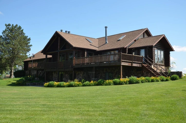
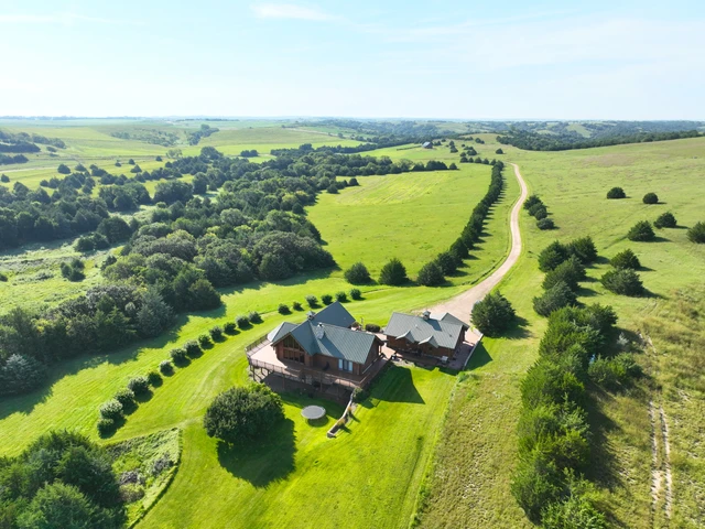
About the Land: 160 Acres, more or less, according to Valley County Assessor’s records. Pivot irrigated cropland with a 4 bedroom/2 bath ranch style home, indoor pool and attached garage and electric submersible well. Also includes an approx. 5,700 sq. ft. steel building, Chief 20,000 bu. Grain bin and older house in the southwest corner. Note: Does not have an irrigation well – in the past water was provided by the well on Tract 3. Not included – livestock fences, panels, gates, pivot system, discharge auger, sweep auger, fans & drying floor in the bin.
Farm Service Agency: (estimate) Corn base – 123 acres, Wheat base – 4.7 acres, Grain Sorghum base – 2.6 acres
Natural Resources District: The land is located in the Lower Loup NRD and has certified irrigation rights for approx. 119.5 acres.
2025 Taxes: $6,052.18
Tract 5 - 160 Acres +/-
Location: Corner of 800 Rd. and Round Barn Ave. – west of Tract 4
Legal Description: Southeast Quarter of Section 22, Township 17 North, Range 14 West of the 6th P.M., Valley County, Nebraska
About the Land: 160 Acres, more or less, according to Valley County Assessor’s records. Pivot irrigated cropland including a Reinke 10 tower pivot system, 50ft. by 120ft. metal storage building and electric submersible well at the bldg. site. Not included – irrigation well motor, pump & panel, calving shed and portable panels.
Farm Service Agency: Corn base – 129.87 acres, Wheat base – 5.36 acres, Grain Sorghum – 2.74 acres
Natural Resources District: The land is located in the Lower Loup NRD and has certified irrigation rights for 128 acres.
Well Data: (per registration) G-047768, July 1975, 418ft. deep, 66ft. static water level, 170ft. pumping level, 700 GPM
2025 Taxes: $4,244.30
Tract 6 - 312.76 Acres +/-
Location: From North Loup, 2 miles west on Hwy. 22 and 1/2 mile south on 483 Ave.
Legal Description: North Half of Section 3, Township 17 North, Range 13 West of the 6th P.M., Valley County, Nebraska
About the Land: 312.76 Acres, more or less, according to Valley County Assessor’s records. Has been irrigated by two Zimmatic pivots, a Reinke 9 tower pivot in the center, two irrigation wells with natural gas and a 5 tower pivot on canal water in the southeast corner. In addition there is a stock well on the north side. Not included – (2) Zimmatic pivots, both well motors, pivot control boxes, canal pump & motor, stock well solar unit and pump.
Farm Service Agency: Corn base – 274.5 acres, Wheat base – 9.6 acres, Grain Sorghum base – 5.8 acres
Natural Resources District: The land is located in the Lower Loup NRD and has certified irrigation rights for 275.8 acres.
Well Data: (per registration) G-051886, April 1976, 311ft. deep, 41ft. static water level, 200ft. pumping level, 800 GPM. G-041675, June 1964, 314ft. Deep, 64ft. Static water level, 140ft. Pumping level, 6” col., 700 GPM
2025 Taxes: $9,402.56
Details
County: Valley
Zipcode: 68859
Property Type One: Farms
Property Type Two: Ranches
Property Type Three: Residential Property
Brokerage: Marshall Land Brokers & Auctioneers
Brokerage Link: www.marshallauction.com

Luke Huddleston
Marshall Land Brokers & Auctioneers
(308) 234-6266
By clicking the button, you agree to our Terms of Use and Privacy Policy.


Nearby Listings
Valley County, NE
$1,400,000 - 36 ac.
Valley County, NE
Auction - 480 ac.
Loup County, NE

$115,000 - 5 ac.
Sherman County, NE

$125,000 - 16 ac.
Custer County, NE
$6,700,000 - 2339 ac.
Howard County, NE
$1,365,000 - 350 ac.
Valley County, NE
$345,000 - 0 ac.
Greeley County, NE
$655,000 - 5 ac.
Valley County, NE
$950,000 - 0 ac.
Sherman County, NE

$339,000 -