

0.27 Acre Power & Water Lines Nearby! In Show Low, Navajo County AZ
1838 Rocky Bottom Pl, Show Low, AZ | Lat/Lng: 34.3480, -110.0015
$14,999
0.27 ac.
01/22/2026
ACTIVE
Description
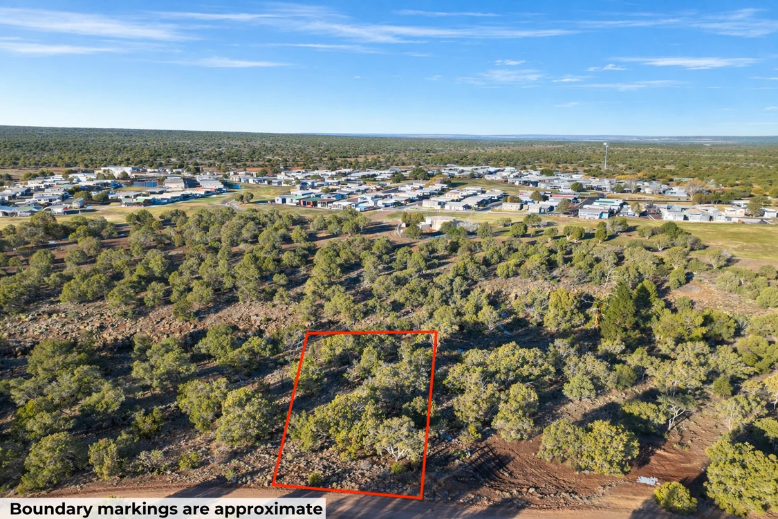
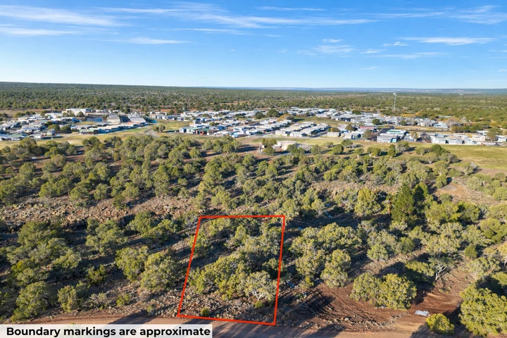
0.27 acres in the White Mountains near Show Low, buildable in an established neighborhood. This lot sits at 1838 Rocky Bottom Pl in the White Mountain Lakes Unit 3 subdivision, on a gentle downhill slope at 6,079 feet. That means cool summers, real winters, and the Apache-Sitgreaves National Forest at your back. Show Low has about 11,000 people, a regional hospital, and a small airport. Flagstaff is 2 hours west, Phoenix about 3 hours south.
Utilities are within reach. Power runs 545 feet east along the front boundary of 8280 Skyline Dr. A private water company has lines near the lot line. Sewage here would be a vault or holding tank rather than full septic, a Navajo County rule for parcels this size in this area. Call the local water company and the county for firm quotes, and we'll send the parcel info to make those calls easy.
Getting here. Access is a gravel road, drivable in a normal vehicle in summer. Plan on AWD in winter or mud season.
Owner financing is available on this lot. No banks. No credit checks. No prepayment penalties. Call or text us at (313) 349-0434 and we'll work out monthly terms that fit your budget. Pay it off early anytime. Buying with cash? We cover your first year of property taxes.
This lot is zoned RU-1, Rural Residential. Site-built homes are allowed and the minimum building size is 1,000 square feet. Mobile, manufactured, and modular homes are not allowed in this zone. No RVs or camping as a residence. The CCRs are written for a single-family community, so you're buying into a built-up neighborhood.
One thing to flag. A small portion of the western boundary (about 0.05 of the 0.27 acres) falls into FEMA Flood Zone AE. That's a 1% annual flood risk, and any structure inside Zone AE needs lender flood insurance. The practical build site is outside Zone AE. Confirm placement with a surveyor, and we'll hand you the elevation map. No wetlands. The survey is on file.
Owner Financing Plan Starts From $1,499 Down
To lock this property in your name, we need both a deposit and a signed purchase agreement. Call or text us anytime at (313) 349-0434 and we'll walk through monthly payment options together.
Details
Address: 1838 Rocky Bottom Pl, Show Low, AZ, 85901
Parcel Number: 304-21-165
Legal Description: Lot 22, Block 23, WHITE MOUNTAIN LAKES UNIT 3, according to Book 9 of Maps, page 5, records of Navajo
County, Arizona
County: Navajo
Size: 0.27 Acre
Property Survey or Plat Map: Yes - refer to documents section
Power: 545 ft East along the front boundary of 8280 Skyline Dr
Water: Private water companys water lines in the area (Provided by Voyager WML: 928-537-8168)
Sewage: Would be Vault / Holding Tank. Property failed perc test
Phone: Cell or Satellite (coverage map)
Zoning: RU-1 Rural Residential
Camping and RV: RV is allowed while building, for six months period
Mobile Homes Allowed?: No
Manufactured Homes Allowed?: No
Site Built Homes Allowed?: Yes
Minimum Square Footage: 1000 sq ft
HOA: None
Flood Zone: No, just a small portion from West boundary falls in a flood zone AE covering 0.05 acres (Refer to Land id map on our web listing)
Wetlands: No (Refer to Land id map on our web listing)
Access: Dirt road
Annual Property Taxes: $98
General Elevation: 6,079 feet
Terrain: Gentle slope downhill
Dimensions: 162 x 80 x 142 x 83 feet
Conveyance: Warranty Deed
Title: Free and Clear
Google GPS Corner Coordinates
NW: 34.34808, -110.00168
NE: 34.34803, -110.00115
SW: 34.34785, -110.00166
SE: 34.34781, -110.00119
Approximate Distance to Nearby Cities & Points of Interest
11 minutes to AZ-77
Show Low offers cool mountain air, beautiful pine trees, and a relaxed small-town feel. The area is known for outdoor fun like hiking, fishing, and exploring nearby lakes. With peaceful surroundings and convenient access to local shops and services, its a great place to enjoy nature while still staying connected.
20 minutes to Show Low: Population 12,366
2 hours 14 minutes to Flagstaff: Population 78,000
3 hours 17 minutes to Phoenix: Population 1,730,000
3 hours 4 minutes to Phoenix Sky Harbor International Airport
Points Of Interest
33 minutes to Fool Hollow Lake Recreation Area
Activities at Fool Hollow Lake Recreation Area: camping, hiking, walking, swimming, boating, fishing, mountain and road biking, wildlife viewing
55 minutes to Sitgreaves National Forest
Activities at Sitgreaves National Forest: hiking, fishing, walking, mountain and road biking, camping, overlanding, off-roading
Are you a hunter or a fisherman?
Game Management Unit: Arizona Game & Fish Department
Nearby hunting areas: Sipe White Mountain Wildlife Area, White Mountain Grasslands Wildlife Area, San Carlos Recreation & Wildlife, Needles Eye Wilderness
Expected game: Elk, Mule deer, Coues (white-tailed) deer, Pronghorn, Black bear, Mountain lion, Javelina, Turkey (Merriams/goulds depending on unit), Desert bighorn sheep (in applicable canyon/wilderness units), Bighorn sheep (Rocky Mountain/desert depending on unit), Sandhill crane (limited areas), Dusky (blue) grouse, Gambels quail, Scaled quail, Montezuma quail, Mourning dove, White-winged dove, Cottontail rabbit, Jackrabbit
Nearby fishing areas: Salt River Wilderness Take-Out, Canyon Lake Palo Verde Boat Launch, River Reservoir South Fishing Site, Mesquite Canyon Park
Expected fish: Rainbow trout, Brown trout, Brook trout, Apache trout, Cutthroat trout (stocked in some lakes), Largemouth bass, Smallmouth bass, Spotted bass, Striped bass (downstream Salt system), Channel catfish, Flathead catfish, Bluegill, Green sunfish, Redear sunfish, Black crappie, White crappie, Walleye (in some reservoirs such as Lyman), Yellow perch (localized), Carp, White bass (Salt system), Threadfin shad (forage), Black bullhead
Lots of nearby walking, hiking, and biking trails to choose from: Picketpost Trailhead, See Canyon Trailhead, Government Springs Trailhead, Horton Creek Trailhead, Peralta Trailhead, Chaparral Pines Trailhead
Call or Text us anytime for questions or to learn more about how to purchase this property.
Details
County: Navajo
Zipcode: 85901
Property Type One: Residential Property
Property Type Two: Undeveloped Land
Brokerage: Compass Land USA
Brokerage Link: www.compasslandusa.com/property
Apn: 304-21-165

Andrew Gaasenbeek
Compass Land USA
(313) 349-0434
By clicking the button, you agree to our Terms of Use and Privacy Policy.


Nearby Listings
Apache County, AZ
$14,995 - 1 ac.
Navajo County, AZ
$94,500 - 10 ac.
Apache County, AZ

$675,000 - 38 ac.
Apache County, AZ
$165 - 1 ac.
Apache County, AZ

$5,999 - 1 ac.
Apache County, AZ
$14,900 - 2 ac.
Apache County, AZ
$540,000 - 27 ac.
Navajo County, AZ

$8,888 - 1 ac.
Apache County, AZ

Auction - 2 ac.
Apache County, AZ
$14,875 - 1 ac.