Idaho County, Idaho Land For Sale (53 results)
Want to post your listings on AcreValue? View Listing Plans
AcreValue offers multiple types of land for sale in Idaho County, so if you’re looking for a new ranch, farm, recreational property, hunting ground, developmental property, or land investment you’ve come to the right place. Regardless of what your needs or objectives are for your land, we have a large inventory of available parcels that are updated regularly. Therefore, it’s very likely that we have the perfect parcel that meets all the search criteria & specifications that you’ve been searching for. Additionally, because our land for sale listings are always being updated due to the frequency of land being sold or new land listings being put on the market, make sure that you are checking back with AcreValue regularly for updates. When you find the perfect land parcel and you are ready to take the next steps you can easily connect directly with the listing agent to help you facilitate your land purchase. Browse AcreValue's Idaho land for sale page to find more potential opportunities in Idaho that fit your needs. We wish you the best of luck in finding your next ranch, farm, recreational property, hunting ground, developmental property, or land investment.

10/14/2025
$33,000,000
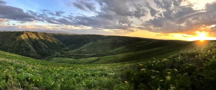
19662 ac.
ACTIVE
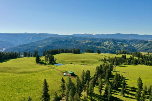
Idaho County - TBD, Cottonwood, ID
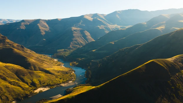
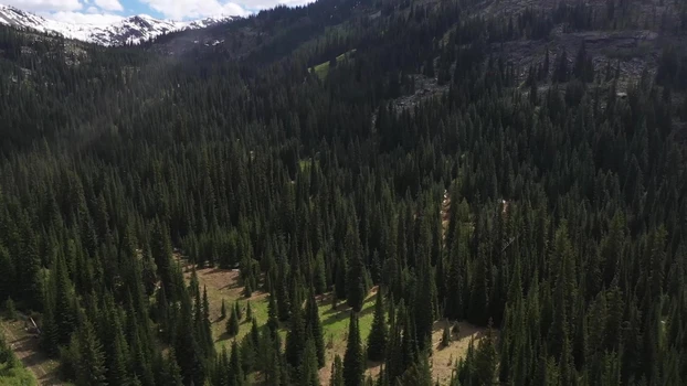
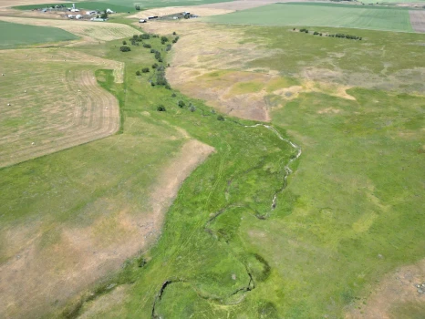
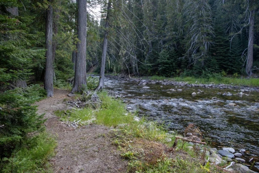
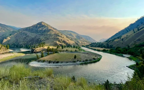
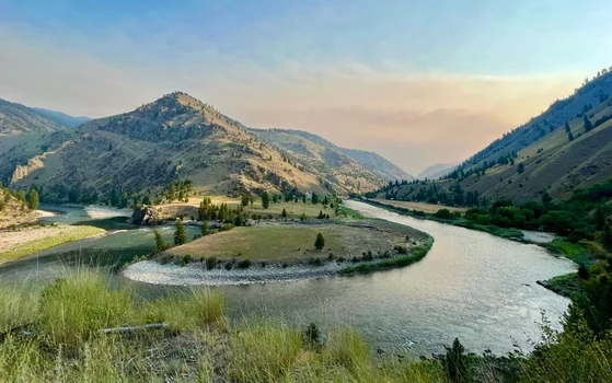
30,000 acre ranch on the Joseph Plains, this ranch features 21 miles of Salmon River frontage, 12 live creeks, and hundreds of springs. Diverse terrain includes meadows, pastures, and timbered draws. With 19,662 deeded acres and 11,000 acres of BLM and State land, it's a hidden gem of secluded, gorgeous, rugged Idaho beauty in the sportsman's paradise of Central IDideal for ranching, hunting, fishing, and endless recreation.
Land
Idaho's largest active ranch, offered for sale for the first time ever. Nestled on and above the legendary Salmon River, known as the River of No Return, which is part of the longest undammed river system and flows through the largest designated Wilderness area in the contiguous United States. The ranch spans in total 30,000 wild and scenic acres, including BLM and State land within and surrounding the ranch. A sportsman's paradise with hunting, fishing and recreation, it also functions as a productive cattle ranch.
This exceptional 30,000 acre Legacy Ranch offers unparalleled privacy, scenic Idaho beauty, and an abundance of usable land. Horseshoed by the Salmon River and enhanced by multiple creeks and natural springs, the property provides rich water resources and a landscape as functional as it is breathtaking.
Located in the highly desired Unit 13, the ranch is a true sportsman's haven. Its diverse terrain of timbered draws, elevated meadows, and sweeping panoramic views supports incredible wildlife populations, including elk, mule deer, white-tail, mountain lion, bear, turkey, and upland birds with bighorn sheep frequenting the Salmon River Canyon. A resident herd of 500 elk frequent the property year-round. The property also qualifies to apply for the (LAP) tags, Landowner Appreciation Program Controlled Hunts for both elk and deer, offering premier hunting opportunities right on-site.
2025 Landowner Appreciation Program Tags available for Unit 13
Deer 13 buck tags, mule deer or white-tail (10/10/25 11/3/25)
Elk 25 cow tags (10/10/25 11/3/25)
Elk 34 either bull or cow tags (10/10/25 11/3/25)
Landowners must register their land before applying for the landowner tags
Surrounded by 11,000 BLM and State landsmany landlocked and rarely accessedthe ranch delivers unmatched seclusion with extended access to Idaho's vast backcountry. Beyond its rich recreation and wildlife, the ranch operates as a productive cattle operation, historically running approximately 300-350 head. With strong grazing capacity and roughly 90 acres of alfalfa hay fields, it combines practical ranching use with lasting investment value.
Just outside Cottonwood, Idaho, the famed Salmon River at the ranch's edge offers world-class salmon and steelhead fishing as well as premier jetboating and whitewater rafting, further enhancing its outdoor lifestyle appeal.
A rare offering that combines expansive land, water, wildlife, this working land is more than a ranchit's a true Idaho legacy.
Improvements
There are three cowboy cabins (older ranch style homes) along with barns, outbuilding, multiple stock ponds and stock tanks.
Recreation
The famed Salmon River, the River of No Return, provides 21 miles of river frontage with miles of beautiful, white sandy beaches and world-class salmon, steelhead, and incredible bass fishing. Towering canyon walls, rugged rock formations, and diverse terrain create a sportsman's paradise with abundant wildlife and premier hunting opportunities. Just like the Salmon River, nearby Clearwater and Snake Rivers offer unmatched whitewater rafting, jet boating, kayaking, and fishing adventures.
Salmon River: The Salmon is known for world-class fishing Chinook salmon, steelhead, rainbow, cutthroat, bull trout, and bass with opportunities for both fly and spin fishing along its clear, free-flowing stretches and tributaries.
Snake River: The Snake is famous for Chinook salmon and steelhead runs, especially in its upper and middle sections near Hells Canyon and the Clearwater confluence. Also well known for sturgeon, trophy small-mouth bass, and catfish.
Clearwater River: The Clearwater is best known for its world-class steelhead and salmon fishing. It's one of the premier trophy steelhead fisheries in the Pacific Northwest. Also, trout, and smallmouth bass.
Beyond the ranch, thousands of acres of BLM and State lands provide endless opportunities for hiking, horseback riding, 4-wheeling, and UTV exploration, making it easy to experience Idaho's rugged backcountry. Together, the ranch and surrounding region offer an unparalleled lifestyle that seamlessly blends outdoor adventure, sport, and premier ranch living.
Agriculture
The ranch is a highly productive cattle operation, historically supporting 300-350 head of livestock across a mix of productive pasture, open meadows, and timbered grazing terrain. Approximately 90 acres of alfalfa hay fields provide additional feed resources, enhancing the ranch's operational capacity.
Water/Mineral Rights & Natural Resources
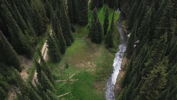
The ranch boasts abundant water resources, including over 12 named live-water creeks that flow through the property and hundreds of springs throughout the acreage. These creeks and springs support thriving wildlife, along with the cattle and contribute to lush pasture and meadow growth. A notable feature on the ranch is Shroyer Springs, a reliable natural spring that enhances the property's water resources and scenic beauty. The 7-mile Shroyer Trail winds through the scenic easement, providing access to sweeping views, varied landscapes, and plentiful wildlife. The ranch also has a hydropower system which supplies power to both cowboy cabins located down on the river.
Skeleton Creek
Guthery Creek
Cottonwood Creek
Dry Creek
Billy Creek
Rickman Creek
Kylie Creek
Home Sweet Home Creek
Burnt Creek
Mahoney Creek
Rattlesnake Creek
Slick Ear Creek
Region & Climate
Located on Idaho's Camas Prairie at roughly 3,500 feet elevation, Cottonwood, ID enjoys four true seasons with warm, dry summers and crisp, snowy winters. With moderate precipitation, a long growing season, and fertile soils, the area supports productive ranching and agriculture. The setting combines wide-open prairie views with nearby mountains, forests, and the Salmon River canyon.
History
Founded in 1862, Cottonwood began as a way station for miners traveling to the goldfields of Florence and Warrens. The town is named after the dense cottonwood trees that once lined Cottonwood Creek. In 1877, it was the site of the Battle of Cottonwood during the Nez Perce War, where Chief Joseph's band engaged U.S. forces in a strategic retreat. Today, Cottonwood honors its rich heritage through landmarks like the Monastery of St. Gertrude, established in 1907, and the James V. and Sophia Baker House, built in 1916.
The Salmon River flows through a swath of Idaho country that is wild and rugged. It originates in the Sawtooth Range of the Stanley Basin and the canyon itself has some of the oldest minerals visible anywhere on earth, turning and winding in all directions through Idaho towards its confluence with the Snake River. The river earned its name The River of No Return for its wilderness and roadless section spanning a large piece of Idaho from Salmon to Riggins, ID. Early Pioneers built sweep boats that served as the supply line into the canyon but upon reaching their destination there was no way to return back to the starting point, with no roads and the powerful river, these boats would then be disassembled and used for lumber. Hence the name River of No Return. Lewis and Clark came across the river in 1805 but found it to be too rough to navigate due to the daunting canyon walls and dangerous rapids. In the 1860s gold was found and the rush began. Many historic and present-day mines can be seen while traveling along the Salmon River.
Location
Nestled in north-central Idaho on the scenic Camas Prairie, Cottonwood serves as a charming gateway to the rugged beauty of Idaho County. The small town is conveniently located along U.S. Highway 95, between Grangeville and Lewiston providing access to nearby recreation, services, and small-town amenities while remaining private and secluded. Surrounded by expansive public lands, forests, and the famed Salmon River, the area is ideal for ranching, hunting, fishing, and outdoor adventures. Cottonwood sits within driving distance of Lewiston (approximately 70 miles northwest) and the Clearwater River, combining the tranquility of rural living with access to regional hubs.

04/03/2025
$399,000
4.49 ac.
ACTIVE
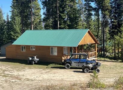
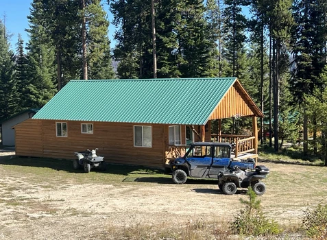
Idaho County - 125 Black Diamond Lane, Dixie, ID
Perfect opportunity for a private hunting camp, investment property, working Lodge or year-round single-family recreational haven! Five buildings and 4.49acs: 1BR, 1BA cabin w/kitchenette, 4-unit building each has attached bath, two have kitchenettes, 1 Cabin with half-bath & full kitchen, a 30x36 Shop, 12x16 outbuilding, used as a hot tub room. A nature lover's dream in the heart of Dixie - hunt, fish, hike, ride horses, ATV's, snowmobiling. Adjacent to public land and nestled between the Gospel-Hump and Frank Church Wilderness and close to Salmon River and Gospel-Hump Lakes. Sleeps 15. Bring your toys!


07/08/2025
$525,000
80 ac.
ACTIVE
Idaho County - NW 80 AC Pack Creek Rd, Powell Junction, ID
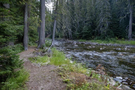
Discover a rare opportunity to own 80-Ac off-grid acres where adventure begins right out your front door. Just 2 miles from Lolo Pass and only 40 minutes from Missoula, this expansive property offers unmatched solar potential, over 3,000 feet of Pack Creek frontage, and excellent access. Nestled in the heart of Idaho's premier wilderness corridor, it's as wild as it is accessible—surrounded by thousands of acres of public land with direct access to groomed cross-country ski and snowmobile trails. Panoramic views of the Bitterroot Mountains set the stage for year-round recreation, abundant wildlife sightings, and total solitude. Whether you're building a seasonal escape, a backcountry basecamp, or a full-time homestead, this land delivers what off-grid living should: clean air, endless skies, silent nights, and the freedom to roam. With rich natural features and proximity to the iconic Lochsa Lodge and hot springs, this is truly a gateway to the best of the West.


07/03/2024
$7,400,000
2825 ac.
ACTIVE
Idaho County - 151 Ranta Rd, Kooskia, ID
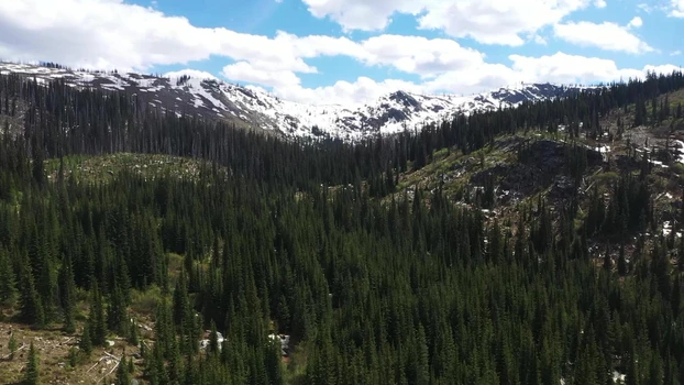
The Henry Cattle Ranch is a game-rich mountain property situated on Harris Ridge, overlooking the Clearwater River. Located just three miles from Kooskia, Idaho, this ranch borders state land and extends into the expansive Clearwater National Forest. The property spans 2,825 deeded acres with another featuring rolling meadows of natural grass and pine-covered ridges that descend into multiple creek drainages, including Sutler Creek and Red Pine Creek, which flow through the property. The Clearwater area is considered the banana belt of Idaho with four seasons but very moderate in temperatures. The ranch has over 370 acres of hay ground along with approx. 700 acres of timber land that has not been cut in years.
Positioned at the end of Harris Ridge Road, the ranch offers complete privacy, boasting both an owner's home at 4,224 sq. ft. 4 beds and 5 baths, built in 2017. There is also a second home for the ranch manager, a 3,132 sq. ft. ranch style home. The charm of this ranch lies in its stunning views of the Clearwater Drainage to the south and the timbered ridges that stretch out on the horizon to the east and south. The ranch teems with wildlife, including resident elk, deer, turkey, bears, and various other predators, making it feel like a true wildlife sanctuary.


07/09/2025
$2,100,000
640 ac.
ACTIVE
Idaho County - NKA 640 AC Shoot Creek Rd, Powell Junction, ID
Discover a rare opportunity to own 640 off-grid acres where adventure begins at your doorstep. Located at the end of a private road with a gated entrance, this property offers extreme privacy, panoramic views of the Bitterroot Mountains, and over a mile of Shoot Creek frontage. An open meadow along the creek is ideal for a cabin retreat. Just 10 miles from Lolo Pass and an hour from Missoula, it provides excellent access, unmatched solar potential, and direct access to public lands, groomed ski, and snowmobile trails. Surrounded by Idaho's premier wilderness corridor, enjoy year-round recreation, abundant wildlife, and total solitude. Whether you're seeking a seasonal getaway, backcountry basecamp, or full-time homestead, this land delivers true off-grid living: clean air, endless skies, silent nights, and freedom to roam. With rich natural features and proximity to the iconic Lochsa Lodge and hot springs, this is your gateway to the best of the West.

05/13/2025
$2,100,000
1520 ac.
ACTIVE
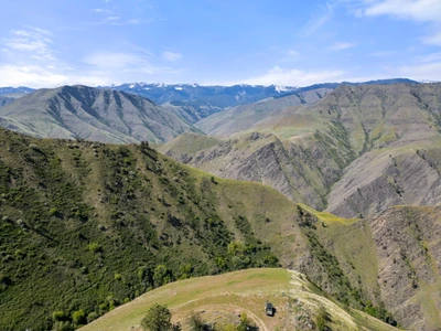
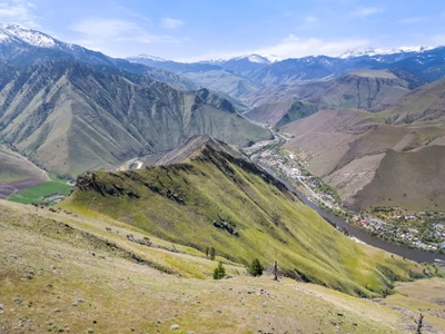
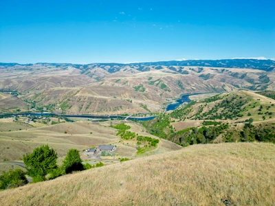
Idaho County - TBD Salmon River, Riggins, ID
Here's your chance to own a breathtaking piece of Idaho just outside Riggins. With views stretching in every direction, this unique property showcases a blend of timber, open meadows, and access to the Salmon River. Bordering national forest, it offers a dream retreat for outdoor enthusiastsideal for hunting, hiking, and recreation.
Land
This exceptional property encompasses 1,520 acres. Bordering the Salmon River, national forest, and BLM land, providing unparalleled scenic beauty and privacy. With elevations ranging from 1760 ft to 4500 ft. it also features multiple water sources, including springs and creeks running through the bottom end of the property.
Located in Hunting Unit 14, this land offers excellent hunting opportunities for quail, chukar, mule deer, white-tail deer, elk, mountain lions and bear while qualifying for the Landowner Appreciation Program (LAP) tags.
Enjoy immaculate and magical views of the expansive landscape. This land is perfect for those seeking a mix of adventure, tranquility, and the ultimate hunting or ranching experience.
Recreation
This property offers excellent hunting opportunities for quail, chukar, mule deer, white-tail deer, elk, and qualifies for Landowner Preference (LAP) tags. The ranch is located in Hunting Unit 14. This unit is notoriously hard to get a tag for, so having the opportunity to obtain both an elk and mule deer tag every year is a significant advantage. Unit 14 has the following tag opportunities:
Whitetail Deer Over the Counter Tag + Draw Only Tag
Mule Deer Draw Only Tag
Elk Over the Counter Tag
Black Bear Over the Counter Tag
With multiple springs and creeks, including Lightning Creek and Cherry Creek, the land provides ample opportunities for fishing and exploring. Enjoy expansive views with timber and meadow landscapes, perfect for nature enthusiasts.
The property borders the Salmon River, national forest, and BLM land, making it ideal for hiking, camping, and other outdoor adventures. Multiple roads provide easy access for recreational vehicles and exploring the vast property. Additionally, the proximity to Riggins offers access to even more outdoor activities and amenities.
The Salmon River is renowned for its incredible recreational opportunities. It offers excellent fishing for species such as steelhead, salmon, trout and bass. Additionally, jetboating, kayaking and whitewater rafting are popular activities on the river.
Region & Climate
Nestled in a canyon where the Salmon River and Little Salmon River meet, Riggins, Idaho, is surrounded by the rugged terrain and stunning landscapes of the Seven Devils and Salmon River Mountains. Adjacent to the vast expanses of the Payette National Forest and the Frank Church-River of No Return Wilderness, one of the largest wilderness areas in the contiguous United States, this area features deep canyons, lush forests, and abundant wildlife, making it a haven for nature enthusiasts and outdoor adventurers. Situated along U.S. Route 95, Riggins provides convenient access to other parts of Idaho and nearby states, serving as a gateway to numerous outdoor activities, including white-water rafting, fishing, hunting, hiking, and camping.
Riggins experiences a semi-arid climate with distinct seasons. Summers are typically hot and dry, with daytime temperatures often reaching into the 80s and 90s (F), but the low humidity makes the heat more bearable, and evenings cool off, providing relief from the daytime heat. Winters are mild, with daytime temperatures generally ranging from the mid-30s to mid-40s (F). Snowfall is typically light in the lower elevations, with heavier snow accumulations in the surrounding higher elevations. The region receives an average annual precipitation of about 20 inches, with most of it falling in the winter and spring months. Summer and early fall are relatively dry, making it an excellent time for outdoor activities. Spring brings wildflowers and lush greenery, while fall showcases vibrant autumn colors. This unique blend of rugged natural beauty, diverse outdoor activities, and a climate that supports year-round recreation makes Riggins, Idaho, a remarkable place to live and explore.
History
Riggins, Idaho, epitomizes the essence of the American West, blending a rich history with abundant natural beauty and rugged wilderness. Founded in 1892 during the mining boom, Riggins thrived as a hub for prospectors and loggers, drawn by the region's wealth of gold and timber. Today, it serves as a gateway to outdoor adventure, offering whitewater rafting, fishing, and exploration in the nearby wilderness areas. While maintaining its frontier spirit, Riggins embraces modern amenities and industries, including tourism, logging, mining and agriculture, all against the backdrop of stunning mountain scenery and the iconic Salmon River.


05/13/2025
$7,100,000
2041 ac.
ACTIVE
Idaho County - TBD Salmon River, Riggins, ID
Here's your chance to own a breathtaking piece of Idaho just outside Riggins. With views stretching in every direction, this unique property showcases a blend of timber, open meadows, and access to the Salmon River. Bordering national forest, it offers a dream retreat for outdoor enthusiastsideal for hunting, hiking, and recreationthis land also presents exciting development potential.
Land
This exceptional property encompasses 2,041 acres. Bordering the Salmon River, national forest, and BLM land, providing unparalleled scenic beauty and privacy. With elevations ranging from 1760 ft to 4500 ft. it also features multiple water sources, including springs and creeks running through the bottom end of the property.
Located in Hunting Unit 14, this land offers excellent hunting opportunities for quail, chukar, mule deer, white-tail deer, elk, mountain lions and bear while qualifying for tags through the Landowner Appreciation Program (LAP).
Enjoy immaculate and magical views of the expansive landscape. This land is perfect for those seeking a mix of adventure, tranquility, and the ultimate hunting or ranching experience.
The property includes a flat area along the river suitable for an airstrip, offering potential for private aircraft access. An old bridge once crossed the river at this location, and there is potential to construct a new one, enhancing accessibility and connectivity across the property.
Recreation
This property offers excellent hunting opportunities for quail, chukar, mule deer, white-tail deer and elk while qualifying for Landowner Preference (LAP) tags. The ranch is located in Hunting Unit 14. This unit is notoriously hard to get a tag for, so having the opportunity to obtain both an elk and mule deer tag every year is a significant advantage. Unit 14 has the following tag opportunities:
Whitetail Deer Over the Counter Tags
Mule Deer Draw Only Tags
Elk Over the Counter Tags
Black Bear Over the Counter Tags
With multiple springs and creeks, including Lightning Creek and Cherry Creek, the land provides ample opportunities for fishing and exploring. Enjoy immaculate and magical views with timber and meadow landscapes, perfect for nature enthusiasts.
The property borders the Salmon River, national forest, and BLM land, making it ideal for hiking, camping, and other outdoor adventures. Multiple roads provide easy access for recreational vehicles and exploring the vast property. Additionally, the proximity to Riggins offers access to even more outdoor activities and amenities.
The Salmon River is renowned for its incredible recreational opportunities. It offers excellent fishing for species such as steelhead, salmon, trout, and sturgeon. Additionally, kayaking and whitewater rafting is a popular activity on the river.
Region & Climate
Nestled in a canyon where the Salmon River and Little Salmon River meet, Riggins, Idaho, is surrounded by the rugged terrain and stunning landscapes of the Seven Devils and Salmon River Mountains. Adjacent to the vast expanses of the Payette National Forest and the Frank Church-River of No Return Wilderness, one of the largest wilderness areas in the contiguous United States, this area features deep canyons, lush forests, and abundant wildlife, making it a haven for nature enthusiasts and outdoor adventurers. Situated along U.S. Route 95, Riggins provides convenient access to other parts of Idaho and nearby states, serving as a gateway to numerous outdoor activities, including white-water rafting, fishing, hunting, hiking, and camping.
Riggins experiences a semi-arid climate with distinct seasons. Summers are typically hot and dry, with daytime temperatures often reaching into the 80s and 90s (F), but the low humidity makes the heat more bearable, and evenings cool off, providing relief from the daytime heat. Winters are mild, with daytime temperatures generally ranging from the mid-30s to mid-40s (F). Snowfall is typically light in the lower elevations, with heavier snow accumulations in the surrounding higher elevations. The region receives an average annual precipitation of about 20 inches, with most of it falling in the winter and spring months. Summer and early fall are relatively dry, making it an excellent time for outdoor activities. Spring brings wildflowers and lush greenery, while fall showcases vibrant autumn colors. This unique blend of rugged natural beauty, diverse outdoor activities, and a climate that supports year-round recreation makes Riggins, Idaho, a remarkable place to live and explore.
History
Riggins, Idaho, epitomizes the essence of the American West, blending a rich history with abundant natural beauty and rugged wilderness. Founded in 1892 during the mining boom, Riggins thrived as a hub for prospectors and loggers, drawn by the region's wealth of gold and timber. Today, it serves as a gateway to outdoor adventure, offering whitewater rafting, fishing, and exploration in the nearby wilderness areas. While maintaining its frontier spirit, Riggins embraces modern amenities and industries, including tourism, logging, mining and agriculture, all against the backdrop of stunning mountain scenery and the iconic Salmon River.


06/24/2025
$375,000
3.84 ac.
ACTIVE
Idaho County - Parcel 1 Packers Meadow Rd 373, Powell Junction, ID
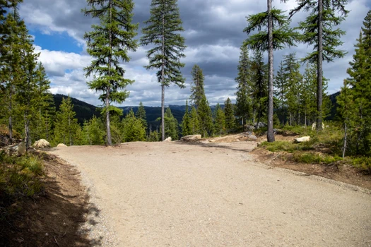
Discover a rare opportunity to own land where adventure begins right out your front door in this off-grid development offering unmatched solar potential just four miles from Lolo Pass, this is your gateway to thousands of acres of pristine public land. Nestled into the headwaters of Pack Creek and the Brushy Fork drainage, this location is as wild as it is accessible, with groomed cross-country skiing and snowmobile trails winding through breathtaking terrain for year-round recreation in one of the Wests most scenic playgrounds. Each homesite boasts panoramic views of the Bitterroot Mountains and direct access to untouched wilderness, providing a front-row seat to natures grandeur, where wildlife sightings are common and solitude is guaranteed. Despite its remote feel, the property is only a 40-minute drive from Missoula, Montana, making it an ideal blend of seclusion and convenience. Grand View 1 offers 3.84 acres with private, gated access off the 373, Packer Meadows Road. This premier lot features exceptional, uninterrupted views of the Brushy drainage and Bass Peak in the distance. With spring water on site, its the optimal place to establish your future basecamp to the backcountry. Two existing pads are ready for buildinga secluded garage or shop site and a homesite nestled among ages-old granite slabs. At the high point of the lot, a rock firepit awaits, where stories are waiting to be told and memories are ready to be made. Whether youre looking for a seasonal escape, a backcountry basecamp, or a full-time wilderness homestead, this development delivers everything an off-grid lifestyle should: clean air, endless skies, silent nights, and room to roam. No power lines, no crowds, just you, the sun, and the freedom to live on your terms.


07/07/2025
$415,000
4.95 ac.
ACTIVE
Idaho County - Parcel 3 Packers Meadow Rd 373, Powell Junction, ID
Discover a rare opportunity to own land where adventure begins at your doorstep in this off-grid development just four miles from Lolo Pass, offering unmatched solar potential and access to thousands of acres of public land. Nestled in the headwaters of Pack Creek and the Brushy Fork drainage, this wild yet accessible setting features groomed trails for year-round recreation. Panoramic views of the Bitterroot Mountains and direct wilderness access provide solitude, abundant wildlife, and natural beauty, just 40 minutes from Missoula. Grand View Parcel 3 is perfect for a multi-family compound or those who desire extra space and room to grow. This lot offers exceptional views of Bass Peak and is tucked among majestic old-growth Tamarack and Spruce trees. Gated access leads to a two-tiered pad layout with two ideal build sites separated by a spacious driveway. With excellent access for any vehicle or RV, this lot is ready to accommodate your wildest building dreams in true off-grid style.

05/13/2025
$5,000,000
521 ac.
ACTIVE
Idaho County - TBD Salmon River, Riggins, ID
Here's your chance to own a breathtaking piece of Idaho just outside Riggins. With views stretching in every direction, this unique property showcases a blend of timber, open meadows, and access to the Salmon River. Bordering national forest, it offers a dream retreat for outdoor enthusiastsideal for hunting, hiking, and recreationthis land also presents exciting development potential.
Land
This exceptional property encompasses 521 acres. Bordering the Salmon River and BLM land, providing unparalleled scenic beauty and privacy. With elevations ranging from 1760 ft to 4500 ft. it also features multiple water sources, including springs and creeks running through the bottom end of the property.
Located in Hunting Unit 14, this land offers excellent hunting opportunities for quail, chukar, mule deer, white-tail deer, elk, mountain lions and bear while qualifying for the Landowner Appreciation Program (LAP) tags.
The property includes a flat area along the river suitable for an airstrip, offering potential for private aircraft access. An old bridge once crossed the river at this location, and there is potential to construct a new one, enhancing accessibility and connectivity across the property.
Recreation
This property offers excellent hunting opportunities for quail, chukar, mule deer, white-tail deer and elk while qualifying for the Landowner Appreciation Program (LAP) tags. The ranch is located in Hunting Unit 14. This unit is notoriously hard to get a tag for, so having the opportunity to obtain both an elk and mule deer tag every year is a significant advantage. Unit 14 has the following tag opportunities:
Whitetail Deer Over the Counter Tags
Mule Deer Draw Only Tags
Elk Over the Counter Tags
Black Bear Over the Counter Tags
With multiple springs and creeks, including Lightning Creek and Cherry Creek, the land provides ample opportunities for fishing and exploring. Enjoy immaculate and magical views with timber and meadow landscapes, perfect for nature enthusiasts.
The property borders the Salmon River, national forest, and BLM land, making it ideal for hiking, camping, and other outdoor adventures. Multiple roads provide easy access for recreational vehicles and exploring the vast property. Additionally, the proximity to Riggins offers access to even more outdoor activities and amenities.
The Salmon River is renowned for its incredible recreational opportunities. It offers excellent fishing for species such as steelhead, salmon, trout, and sturgeon. Additionally, kayaking and whitewater rafting is a popular activity on the river.
Region & Climate
Nestled in a canyon where the Salmon River and Little Salmon River meet, Riggins, Idaho, is surrounded by the rugged terrain and stunning landscapes of the Seven Devils and Salmon River Mountains. Adjacent to the vast expanses of the Payette National Forest and the Frank Church-River of No Return Wilderness, one of the largest wilderness areas in the contiguous United States, this area features deep canyons, lush forests, and abundant wildlife, making it a haven for nature enthusiasts and outdoor adventurers. Situated along U.S. Route 95, Riggins provides convenient access to other parts of Idaho and nearby states, serving as a gateway to numerous outdoor activities, including white-water rafting, fishing, hunting, hiking, and camping.
Riggins experiences a semi-arid climate with distinct seasons. Summers are typically hot and dry, with daytime temperatures often reaching into the 80s and 90s (F), but the low humidity makes the heat more bearable, and evenings cool off, providing relief from the daytime heat. Winters are mild, with daytime temperatures generally ranging from the mid-30s to mid-40s (F). Snowfall is typically light in the lower elevations, with heavier snow accumulations in the surrounding higher elevations. The region receives an average annual precipitation of about 20 inches, with most of it falling in the winter and spring months. Summer and early fall are relatively dry, making it an excellent time for outdoor activities. Spring brings wildflowers and lush greenery, while fall showcases vibrant autumn colors. This unique blend of rugged natural beauty, diverse outdoor activities, and a climate that supports year-round recreation makes Riggins, Idaho, a remarkable place to live and explore.
History
Riggins, Idaho, epitomizes the essence of the American West, blending a rich history with abundant natural beauty and rugged wilderness. Founded in 1892 during the mining boom, Riggins thrived as a hub for prospectors and loggers, drawn by the region's wealth of gold and timber. Today, it serves as a gateway to outdoor adventure, offering whitewater rafting, fishing, and exploration in the nearby wilderness areas. While maintaining its frontier spirit, Riggins embraces modern amenities and industries, including tourism, logging, mining and agriculture, all against the backdrop of stunning mountain scenery and the iconic Salmon River.

07/09/2025
$1,120,000
320 ac.
ACTIVE
Idaho County - N 320 AC Shoot Creek Rd, Powell Junction, ID
Discover a rare opportunity to own 320 off-grid acres where adventure begins at your doorstep. Located at the end of a private road with a gated entrance, this property offers extreme privacy, panoramic views of the Bitterroot Mountains, and over a 1/2 mile of Shoot Creek frontage. An open meadow along the creek is ideal for a cabin retreat. Just 10 miles from Lolo Pass and an hour from Missoula, it provides excellent access, unmatched solar potential, and direct access to public lands, groomed ski, and snowmobile trails. Surrounded by Idaho's premier wilderness corridor, enjoy year-round recreation, abundant wildlife, and total solitude. Whether you're seeking a seasonal getaway, backcountry basecamp, or full-time homestead, this land delivers true off-grid living: clean air, endless skies, silent nights, and freedom to roam. With rich natural features and proximity to the iconic Lochsa Lodge and hot springs, this is your gateway to the best of the West.

02/17/2026
$2,500,000
580.99 ac.
ACTIVE
Idaho County - 216 Ulmer Road, Kooskia, ID
PROPERTY:
Discover one of North Central Idaho's most remarkable ranch properties, a sprawling 580+ acre estate. Offered for the first time in decades, this extraordinary property blends agricultural and recreational potential. The land features expansive, usable acreage with diverse terrain, ideal for livestock, farming, hunting, or a private recreational retreat. Abundant wildlife, great views, at the end of the road. Improvements include a comfortable 3-bedroom, 1.5-bath residence, attached garage, multiple shops, large hay barn, additional barns, and additional outbuildings, providing ample space for equipment, storage, and ranch operations. A potential rock pit on site as well as private wells and a 10,000-gallon gravity feed cistern support the property, adding reliability and long-term value for both residential and agricultural use. This once operational family cattle ranch supported several head of cattle under the KU brand. This family legacy property has the ablilty to supplement another family legacy with agricultural operations or recreational activities.
LAND FEATURES:
Operational Cattle Ranch
Private Wells
10,000 Gal Gravity Feed Cistern
End of the Road Property
Tillable Acreage
Ample Wildlife: Elk, Deer, Turkeys, Bear, Upland Game Birds
Marketable Timber
All Accessible Acreage
RECREATION:
Nestled in the scenic Clearwater River Valley, Kooskia is a small Idaho town that serves as a gateway to some of the state's most spectacular outdoor recreation. The area is surrounded by lush forests, rolling hills, and the winding Clearwater River. The Clearwater River provides excellent opportunities for fishing, kayaking, and floating. Nearby forests and state lands offer miles of hiking trails that showcase Idaho's rugged beauty. Hikers may encounter deer, elk, and a variety of bird species. Kooskia and the surrounding Clearwater National Forest have numerous campgrounds, both developed and primitive, ideal for family trips or solo adventures. Beyond outdoor recreation, Kooskia has a charming small-town vibe with historic sites and scenic drives along the river corridor. The town's location also makes it a convenient stop for exploring the Lewis and Clark Trail and nearby Nez Perce National Historical Park.
The Ulmer Ranch lies within Idaho Fish and Game Hunting Unit 16. This unit offers several over the counter big game hunting opportunities inlcluding: Elk, Whitetail Deer, Mule Deer, Turkeys, Mountain Lion, Wolf, and Bear.REGION & CLIMATE:
The town of Kooskia is modest but functional, with a few local businesses, a post office, a grocery store, local bank and small service shops. It has that small-town charm where independent businesses are central to daily life. Expanded shopping, healthcare and dining options-including Costco, Walmart, Home Depot and other major retailers are located in Lewiston, roughly 75 miles to the West. Air travel is served by the Lewiston-Nez Perce County Airport (LWS), offering daily commercial flights, with additional regional and international service available at Pullman-Moscow Regional Aiport (PUW) and Spokane International Airport, both within a few hours drive.
The area experiences a comfortable four-season climate typical of north-central Idaho's river valleys. Summers are generally warm and dry, with plenty of sunshine and moderate temperatures. Spring and fall bring mild conditions and seasonal color, with cooler winters offering light snowfall in town and increased snow accumulation at higher elevations. Overall, the climate offers distinct seasons without extreme heat, contributing to the region's appeal for those who enjoy a balanced, outdoor-oriented lifestyle.
HISTORY:
Kooskia, Idaho (pronounced Koos-kee) is a small historic community in Idaho County located at the confluence of the Middle Fork and South Fork of the Clearwater River. Long before settlement, the area was home to the Nez Perce people, and the town's name comes from a Nez Perce word commonly interpreted as "where the waters meet." The town was originally called Stuart and was officially platted in 1895 after land from the Nez Perce Reservation was opened to homesteading. Kooskia began to grow with the arrival of the railroad in the late 1890s, which brought commerce and helped establish farming, ranching, logging, and timber as the backbone of the local economy.

07/08/2025
$2,016,000
640 ac.
ACTIVE
Idaho County - NKA 640 AC Pack Creek Rd, Powell Junction, ID
Discover a rare opportunity to own 640 off-grid acres where adventure begins right out your front door. Just 2 miles from Lolo Pass and only 40 minutes from Missoula, this expansive property offers unmatched solar potential, over 6,000 feet of Pack Creek frontage, and excellent access. Nestled in the heart of Idaho's premier wilderness corridor, it's as wild as it is accessiblesurrounded by thousands of acres of public land with direct access to groomed cross-country ski and snowmobile trails. Panoramic views of the Bitterroot Mountains set the stage for year-round recreation, abundant wildlife sightings, and total solitude. Whether you're building a seasonal escape, a backcountry basecamp, or a full-time homestead, this land delivers what off-grid living should: clean air, endless skies, silent nights, and the freedom to roam. With rich natural features and proximity to the iconic Lochsa Lodge and hot springs, this is truly a gateway to the best of the West.

01/20/2026
$199,000
17.75 ac.
ACTIVE
Idaho County - TBD Wasem Road Lot 1, Cottonwood, ID
PROPERTY:
Fantastic Large building parcel on the Camas Prairie near Cottonwood, Idaho. This lot offers seasonal creek frontage, power on site, completed perc test and wonderful views of the Camas Prairie and surrounding mountains. The property has been surveyed. A new entrance gate and fence will greet you as you enter the property, the property is suitable for a homesite, small-scale agriculture, or recreational use..
LAND FEATURES:
New Entrance Gate
Junction Box On Site
Underground Power
Surveyed
Mountain Field Views
Building Lot
County Road Access
RECREATION:
Wasem Road is defined by gently rolling foothills, open pastureland, and wide prairie views, offering a peaceful rural setting well suited for low-impact, open-space recreation. Situated along the edge of the Camas Prairie, this landscape blends working agricultural lands with natural grasslands, creating a scenic environment that feels expansive and uncrowded. While the immediate area emphasizes open pasture and foothill recreation, it offers convenient access to nearby public lands, forested terrain, and the Salmon River corridor.
REGION & CLIMATE:
This region is known for its open agricultural landscapes, gently rolling foothills, and strong rural character, with convenient access to daily services. The town of Cottonwood is only a short drive away, offering residents and visitors access to a grocery store, a post office, banking services, and local schools, without long-distance travel. The nearby community of Grangeville, situated to the southeast along U.S. Highway 95, serves as a larger regional hub offering expanded amenities such as full-service grocery stores, medical facilities, retail shopping, farm and ranch suppliers, and professional services.
The Wasem Road area experiences a continental, semi-arid climate, with four distinct seasons. Summers are generally warm, dry, and sunny, with daytime temperatures commonly in the 80s with cooler evenings. Fall brings cooler temperatures and stable weather, with crisp mornings and warm afternoons. This season is marked by harvest activity and changing colors across fields and surrounding foothills. Winters are cold with regular snowfall. Spring conditions are variable, with warming temperatures, snowmelt, and periodic rain.
HISTORY:
Euro-American settlement in the mid-to-late 19th century brought homesteaders to the Camas Prairie. The fertile soils, open terrain, and relatively mild climate made the region well suited for farming and ranching, and settlers quickly established cropland, pasture, and livestock operations. Roads such as Wasem Road developed to connect rural properties, facilitate farm and ranch activities, and link residents to nearby Cottonwood and emerging regional communities. Throughout the 20th century, the area retained its agricultural character, with low-density development and continued reliance on family farms and ranches.

10/30/2025
$225,000
37.96 ac.
ACTIVE
Idaho County - 200-298 Saddle Ridge Rd, White Bird, ID
Wonderful 37.96-acre lot overlooking the Salmon River, just 4 miles from Hwy 95. This lot is tucked away off of Saddle Ridge Road in the Twin River Ranch Subdivision near White Bird, ID. Just minutes from the Salmon River enjoy fishing, hunting, hiking, and rafting in one of Idaho's most scenic areas, mixing history, beautiful views and adventure. This property is ideal for a year-round home, or summer get away.
Land
This 37.96-acre parcel sits just above Hammer Creek, offering commanding views of the Salmon River and the surrounding mountains. With easy access to the river and nearby Highway 95, just 4 miles away, this property offers a combination of seclusion and accessibility.
Spectacular Views: Enjoy panoramic views of the Salmon River Valley and the surrounding mountain landscape.
River Access: Minutes from the banks of the Salmon River, offering fishing, rafting, and year-round water recreation.
Recreational Paradise: Located in a region known for hunting (Unit 13), fishing, boating, hiking, and off-road adventures.
Accessible Location: Just 4 miles off Highway 95, providing year-round access without sacrificing privacy.
Ideal Building Site: Great build site with breathtaking views, perfect for a cabin, full-time residence, or recreational retreat.
Power Pole on Property
Protective CCRs
Public Land Nearby
Recreation
White Bird, Idaho is a nature lover's paradise, offering a wide range of outdoor recreational opportunities for visitors and residents alike. Surrounded by stunning natural beauty, the area is home to a diverse range of wildlife and outdoor landscapes. One of the most popular recreational activities in White Bird is fishing. The nearby Salmon River is a world-renowned fishing destination, offering some of the best trout and steelhead fishing in the world. Anglers can fish from the riverbanks or take a guided float trip down the river to cast their lines in some of the most scenic spots in the area.
Hiking is another popular activity in White Bird, with a range of trails available for all skill levels. Visitors can explore the nearby Nez Perce-Clearwater National Forests, which offer miles of hiking trails through forests, meadows, and rugged mountain terrain. The Lewis and Clark Trail also runs through the area, providing an opportunity to follow in the footsteps of the famous explorers.
White Bird is also a popular destination for hunters, with a range of game species available for hunting in the surrounding forests and mountains. Deer, elk, and bear are just a few of the game species that can be found in the area. For those who love water sports, the Salmon River and nearby Snake River offer opportunities for kayaking, canoeing, and rafting. Visitors can take guided trips down the rivers or rent equipment to explore on their own.
Finally, White Bird is a great destination for those who love to camp and enjoy the great outdoors. With a range of camping options available, visitors can choose from everything from primitive campsites to RV parks with full hookups.
Overall, White Bird, Idaho is an outdoor enthusiast's dream come true, with endless opportunities for hiking, fishing, hunting, water sports, and camping. With stunning natural beauty and a range of recreational activities available year-round, White Bird is the perfect destination for anyone looking to get away from it all and experience the beauty of Idaho's great outdoors.
Region & Climate
White Bird, Idaho has a semi-arid climate with hot summers and cold winters. The area experiences four distinct seasons. Summers are hot, with average temperatures in the high 80s to low 90s Fahrenheit. The hottest months are typically July and August.
Fall is mild and pleasant, with average temperatures in the 60s to low 70s Fahrenheit and little precipitation. The area is known for its beautiful autumn foliage, with the changing colors of the trees creating stunning scenery throughout the region.
Winters in White Bird have average temperatures in the 30s to low 40s Fahrenheit and occasional periods of sub-zero temperatures. The area typically receives around 30-40 inches of snow each year but it melts quickly and typically is snow free.
Spring is a transitional season, with temperatures gradually warming up and occasional rain showers. The average temperatures in the spring months range from the 50s to low 70s Fahrenheit, with May typically being the wettest month of the year.
History
White Bird, Idaho, situated in Idaho County, holds a storied past deeply rooted in the interactions between indigenous tribes and European settlers. Named after a Nez Perce chief, it witnessed a pivotal moment in the Nez Perce War of 1877, the Battle of White Bird Canyon. Following conflicts, White Bird grew as a hub for ranching, logging, and mining, benefiting from its fertile land and proximity to natural resources. Today, it retains its historical charm, serving as a gateway to outdoor recreation and hosting events like the White Bird Rodeo, honoring its western heritage and enduring spirit.
Location
Nestled in Idaho County, White Bird, Idaho, enjoys a scenic setting surrounded by rolling hills and the winding Salmon River. Nearby towns like Riggins, just 30 miles south, and Grangeville, 14 miles north, offer essential amenities such as lodging, dining, grocery stores, and medical facilities. For travelers, Lewiston-Nez Perce County Airport (LWS) provides convenient access, located approximately 88 miles north and offering primarily domestic flights. Larger airports like Spokane International Airport (GEG), about 194 miles north, and Boise Airport (BOI), approximately 189 miles to the south, cater to a broader range of domestic and international destinations, ensuring connectivity to the rest of the world from this corner of Idaho.


07/07/2025
$460,000
6.69 ac.
ACTIVE
Idaho County - Parcel 4 Packers Meadow Rd 373, Powell Junction, ID
Discover a rare opportunity to own land where adventure begins at your doorstep in this off-grid development just four miles from Lolo Pass, offering unmatched solar potential and access to thousands of acres of public land. Nestled in the headwaters of Pack Creek and the Brushy Fork drainage, this wild yet accessible setting features groomed trails for year-round recreation. Panoramic views of the Bitterroot Mountains and direct wilderness access provide solitude, abundant wildlife, and natural beauty, just 40 minutes from Missoula. Grandview Parcel 4 sits behind a private gate, with a driveway leading to one of the most spectacular views of Bass Peak in the area. Perched above the Spruce drainage, this lot offers exceptional privacy and stunning potential to build the ultimate retreat. As the highest elevation lot currently available in the development, standing on this homesite feels truly specialan ideal setting for those seeking peace, beauty, and a true connection to the land.

07/07/2025
$495,000
6.47 ac.
ACTIVE
Idaho County - Parcel 2 Packers Meadow Rd 373, Powell Junction, ID
Discover a rare chance to own land where adventure starts at your doorstep in this off-grid development just four miles from Lolo Pass, with exceptional solar potential and direct access to thousands of acres of public land. Located in the headwaters of Pack Creek and the Brushy Fork drainage, this wild yet accessible setting offers year-round recreation with groomed trails and stunning views of the Bitterroot Mountains, just 40 minutes from Missoula. Grand View Parcel 2, the crown jewel of the development, boasts uninterrupted views of Bass Creek and the Spruce Creek drainage. It features a unique building opportunity with a drive-up garage pad and a separate homesite nestled among granite outcrops and pine forest. Ideal for those seeking privacy, this parcel includes a private trail to a custom-built firepitperfect for unwinding after a day of adventure. Whether you seek solitude, scenery, or a basecamp to explore the wilderness, this lot delivers it all in true off-grid style.
09/12/2025
$875,000
8.48 ac.
ACTIVE
Idaho County - NKA Parcel 1 Highway 12, Powell Junction, ID
Welcome to Island Manor, a rare find just east of Powell, Idaho, on Highway 12. This nearly 9-acre property is the last of its kind in the Lochsa drainage and offers unmatched access to nature with year-round convenience. A private building site nestled in the cedars overlooks Crooked Fork Creek and abundant wildlife. A trail from the driveway winds through towering trees to the creek banks and a private island—perfect for fishing, relaxing, and enjoying privacy with over 900 feet of frontage. Power is on site, an uncommon benefit in this area. Less than 2 miles away, the iconic Lochsa Lodge provides dining, a store, and the only fuel station for miles. Missoula is about an hour's drive, making this the ideal blend of seclusion and accessibility. With pristine surroundings, a prime homesite, and unmatched natural beauty, Island Manor is truly a one-of-a-kind opportunity in northern Idaho.

10/22/2025
$6,750,000
21.34 ac.
ACTIVE
Idaho County - Riggins, ID
Mackay Bar Outfitters and Guest Ranch (or simply Mackay Bar Ranch) is a 21+/- acre backcountry sanctuary nestled deep within the Payette National Forest at the heart of the Frank Church-River of No Return and Gospel Hump Wilderness Areas. The ranch boasts approximately 3,000 feet of frontage on the main stem of the Salmon River, a National Wild and Scenic River and one of America's longest undammed, free-flowing waterways. A collection of tasteful, immaculately maintained ranch buildings, including the lodge, owner's home, multiple guest cabins, staff housing, and operational structures, are perched above the Salmon with views of the surrounding canyon and direct access to a white sand beach. The residential structures all have modern conveniences and are serviced by a comprehensive, off-grid power system featuring a hydroelectric power plant along with new propane generators, solar panels, inverters, and robust battery storage. Mackay Bar is one of the more accessible properties in the Salmon River Canyon and is primarily reached by jetboat from the Vinegar Creek boat landing 25 miles downstream and aircraft using the ranch's 1,900+/- foot runway. The property can also be accessed by vehicle using a seasonal national forest road from Dixie, about 25 miles north of the property. Mackay Bar Ranch operates as one of the premier outfitting and guest destinations in the northern Rockies, utilizing U.S. Forest Service special use permits for exclusive big game hunting on 200,000+/- acres of surrounding wilderness areas and commercial jet boat services on 80+/- miles of the Salmon River for fishing, upland hunting, hiking, touring, and wildlife viewing. The ranch is offered turnkey with business assets, permits, furnishings, and equipment, including two 28-foot, custom jet boats. Mackay Bar offers significant management flexibility depending on one's goals. The next owner can leverage the ranch's existing reputation, customer base, and market presence to operate the outfitting and hospitality business or simply enjoy the ranch as a private refuge, while taking advantage of the outfitting permits for a steady income stream.
The Facts:
~ Unique 21+/- acre backcountry ranch surrounded by national forest and federal wilderness areas
~ Over a half mile of frontage on the main stem of the Salmon River, a National Wild and Scenic River
~ Reachable by jet boat, aircraft, or vehicle
~ Tasteful and well-maintained structures include a lodge with ample outdoor living space, an owner's home, guest cabins, and staff housing
~ Licensed irrigation, commercial, and hydropower water rights from multiple sources
~ Multiple special-use permits for guided big game hunting in the adjoining wilderness areas and commercial jet boat use on the Salmon River
~ Accommodates up to 28 guests, while "glamping" style wall tents provide extra room for large groups
~ Offered turnkey with business assets, permits, furnishings, and equipment, including two custom-built, twin-engine jet boats
~ Diverse wildlife includes elk, mule deer, whitetail deer, bighorn sheep, mountain goat, cougar, black bear, wolves, and various upland bird species
~ Fishing opportunities include spring and fall steelhead, smallmouth bass, and resident cutthroat and rainbow trout
~ Setting for one of the West's premier outfitting and guest operations
~ Well-suited for ongoing commercial operations or as an exclusive private retreat


01/20/2026
$1,500,000
920 ac.
ACTIVE
Idaho County - TBD Boles Road, Cottonwood, ID
PROPERTY:
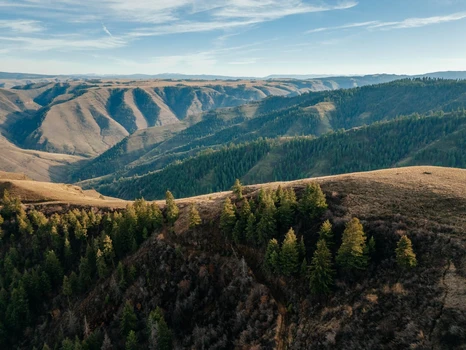
Wonderful 920 acre Mountain Ranch on Joesph Plains in Rural Idaho. This property offers a diverse landscape and countless opportunities for enjoyment. The ranch has flat timbered ridges with creeks and ponds throughout, leading to steeper canyon draws that hold Elk, Deer, Bear and several other game species. The property lays in Unit 13 a draw unit for Elk and Mule Deer, but over the counter tags for Whitetail Deer. The property has several roads throughout for adequate access. The property would be great for pasture, hunting property or a wonderful spot for a family cabin. In addition to the 920 deeded acres the ranch also borders an additional nearly 1000 acres of BLM ground that has limited access other than from this ranch.
LAND FEATURES:
Borders Public Land
Excellent Hunting Opportunities (Unit 13)
Pasture Land
Marketable Timber
Canyon Rim
Exceptional Views
RECREATION:
Joseph Plains is characterized by timbered ridges, grassy high meadows, steep canyon draws, creeks, and pond features. Joseph Plains and the surrounding public lands provide habitat for elk, mule deer, whitetail deer, black bear, turkey, grouse, and other species. It's considered a high-value area for big game hunting during open seasons. The area lies within Idaho Fish and Game Hunt Unit 13. Land Owner Permits maybe avaliable per acreage requirements.
REGION & CLIMATE:
The area sits on the Western edge of the Camas Prairie and transitions into the rugged uplands and canyon country of the Salmon River region. Characterized by wide open spaces, low population density, and a strong agricultural and ranching heritage. Public lands, private ranchlands, and wildlife habitat are interwoven throughout the area, contributing to its remote and undeveloped character. Joseph Plains offers expansive views toward the Salmon River breaks, Snake River Breaks, the Camas Prairie, and surrounding mountain foothills.
The climate of the Joseph Plains area is best described as continental and semi-arid, with four distinct seasons and notable elevation-driven weather patterns. Summers are typically warm to hot and dry, Low humidity and cool evening temperatures make summer comfortable for outdoor recreation. Autumn brings cooler temperatures, crisp air, and vibrant seasonal color across grasslands and timber. This is a prime time for recreation and hunting, with generally stable weather and decreasing precipitation. Winters are cold and snowy, especially at higher elevations. Snowfall can limit access on unimproved roads, including Boles Road, from late fall through early spring. Spring is marked by snowmelt, greener landscapes, and variable conditions.
HISTORY:The Joseph Plains area, located south of Cottonwood, Idaho, lies within a region with a long human history shaped by Indigenous presence, early exploration, agriculture, and ranching. Long before Euro-American settlement, this landscape was part of the traditional homeland and seasonal use areas of the Nez Perce (Nimiipuu) people. The plains, timbered ridges, and nearby river corridors provided important resources for hunting, root gathering, travel, and trade. The broader region remains culturally significant to the Nez Perce Tribe today. During the mid-1800s, increased Euro-American activity followed the opening of trails and wagon routes through north-central Idaho. The Camas Prairie, adjacent to Joseph Plains, became an important agricultural hub due to its fertile soils and favorable growing conditions. Settlement expanded as homesteaders established farms, grazing allotments, and ranches, shaping much of the open landscape seen today.


09/26/2025
$399,000
4.49 ac.
ACTIVE
Idaho County - 125 Black Diamond Lane, Dixie, ID
Perfect opportunity for a private hunting camp, investment property, working Lodge or year-round single-family recreational haven! Five buildings and 4.49acs: 1BR, 1BA cabin w/kitchenette, 4-unit building each has attached bath, two have kitchenettes, 1 Cabin with half-bath & full kitchen, a 30x36 Shop, 12x16 outbuilding, used as a hot tub room. A nature lover's dream in the heart of Dixie - hunt, fish, hike, ride horses, ATV's, snowmobiling. Adjacent to public land and nestled between the Gospel-Hump and Frank Church Wilderness and close to Salmon River and Gospel-Hump Lakes. Sleeps 15. Bring your toys!

02/11/2026
$1,175,000
5 ac.
ACTIVE
Idaho County - 188 Golden Acres Drive, Grangeville, ID
PROPERTY:
Experience rural mountain luxury living in this extraordinary, recently finished custom 4-bedroom, 4 full bathrooms, two story estate on 5 maintainable, fully fenced acres. This gorgeous property is 10 minutes from town, yet close to some of the best big game hunting in the state of Idaho and is within an hour of 3 major rivers that offer incredible fishing. Spacious barn covered RV parking, 2 car garage, and the massive double bay shop with an office above and an additional attached storage room that can easily be a 5th bedroom. The expansive 5840 ft floor plan seamlessly connects the living spaces, creating an ideal environment for both entertaining & comfort. The second, full butlers' kitchen, with stainless appliances and inlaid copper sink is what most homes boast as the only kitchen. Every detail has been meticulously crafted from the massive gourmet kitchen w/custom granite island, custom cabinets and all new stainless appliances. Come see this home in person and you will never want to leave!
LAND FEATURES:
Fully Fenced Property
Large Shop With Additional Storage/Office Space
Covered RV Parking
Private Road Access
Shared Well
Expansive Mountain & Valley Views
Peaceful Rural Setting
RECREATION:
Grangeville, Idaho, is surrounded by exceptional recreational opportunities, making it a gateway to some of north-central Idaho's most scenic outdoor areas. The community sits within easy reach of multiple rivers, including the Salmon River, South Fork of the Clearwater River, and Main Clearwater River, all well known for fishing, rafting, boating, and wildlife viewing. Vast expanses of publicly owned land lie just outside of town, including the Nez Perce-Clearwater National Forests and extensive Bureau of Land Management holdings, offering year-round access to hiking, camping, hunting, horseback riding, and off-road recreation. With mountains, river canyons, and open forests nearby, Grangeville provides residents and visitors alike with abundant outdoor recreation in a largely undeveloped and accessible natural setting.
REGION & CLIMATE:
Grangeville is a city located in north-central Idaho, in the United States. It serves as the county seat of Idaho County. The city is situated within the Camas Prairie, a vast, rolling prairie region surrounded by mountains. Grangeville is nestled in the Nez Perce National Forest, contributing to its scenic surroundings.
Geographically, Grangeville is positioned at an elevation of approximately 3,500 feet above sea level. The nearby Salmon River, one of the major rivers in the region, adds to the picturesque landscape. The city is surrounded by hills and mountains, providing residents and visitors with outdoor recreational opportunities such as hiking, camping, and fishing.
Grangeville is accessible by road, and U.S. Route 95 passes through the city, connecting it to other towns and cities in the region. The region's natural beauty and proximity to outdoor activities make Grangeville a popular destination for those seeking a rural and scenic environment in Idaho.
Grangeville experiences a continental climate with distinct seasons. Winters are typically cold, with temperatures often dropping below freezing. Snowfall is common during the winter months, contributing to winter sports opportunities in the nearby mountains.
Summers in Grangeville are warm and dry. Daytime temperatures can rise into the 80s and 90s Fahrenheit. The area benefits from relatively low humidity during the summer, making it more comfortable despite the warm temperatures.
HISTORY:
Grangeville was officially established in 1875. The town was named after the Grange, a farmers' organization that played a significant role in the development of agricultural communities across the United States. The Grange movement sought to improve the economic and social well-being of farmers. Like many towns in Idaho, Grangeville experienced growth due to mining activities. The discovery of gold and other minerals in the surrounding mountains brought prospectors and settlers to the area. Additionally, the timber industry played a crucial role in the local economy, with the surrounding forests providing valuable resources for logging. Agriculture became a key economic activity for the region, with the Camas Prairie providing fertile soil for farming. The Nez Perce Indians were known for cultivating camas roots, a staple food source. Over time, agriculture diversified to include crops like wheat, barley, and peas. Today, Grangeville retains its small-town charm and serves as a gateway to outdoor recreation in the surrounding natural landscapes. The town's history is evident in its architecture, community events, and the resilience of its residents.
01/20/2026
$131,000
3.36 ac.
ACTIVE
Idaho County - 164 Ridge View Drive, Grangeville, ID
PROPERTY:
Build your dream home on this 3.36-acre lot on the Grangeville Golf Course in the sought after Crimson Ridge Subdivision. Located just outside of town with paved road access, this property gives you space, views, and convenience all in one. Enjoy country living with the golf course at your back door and town only minutes away. The lot is located just off the hole 1 green. A paved cart path leads you from your front door directly to the Golf Course.
LAND FEATURES:
Private Paved Road Access
Borders Golf Course (Hole 1 Green)
Direct Paved Cart Access
Paved Walking Path/Bike Trail
CCR's
Amazing Views
Power at Site
Level Site
RECREATION:
Grangeville, Idaho, is surrounded by exceptional recreational opportunities, making it a gateway to some of north-central Idaho's most scenic outdoor areas. The community sits within easy reach of multiple rivers, including the Salmon River, South Fork of the Clearwater River, and Main Clearwater River, all well known for fishing, rafting, boating, and wildlife viewing. Vast expanses of publicly owned land lie just outside of town, including the Nez Perce-Clearwater National Forests and extensive Bureau of Land Management holdings, offering year-round access to hiking, camping, hunting, horseback riding, and off-road recreation. With mountains, river canyons, and open forests nearby, Grangeville provides residents and visitors alike with abundant outdoor recreation in a largely undeveloped and accessible natural setting.
REGION & CLIMATE:
Grangeville is a city located in north-central Idaho, in the United States. It serves as the county seat of Idaho County. The city is situated within the Camas Prairie, a vast, rolling prairie region surrounded by mountains. Grangeville is nestled in the Nez Perce National Forest, contributing to its scenic surroundings.
Geographically, Grangeville is positioned at an elevation of approximately 3,500 feet above sea level. The nearby Salmon River, one of the major rivers in the region, adds to the picturesque landscape. The city is surrounded by hills and mountains, providing residents and visitors with outdoor recreational opportunities such as hiking, camping, and fishing.
Grangeville is accessible by road, and U.S. Route 95 passes through the city, connecting it to other towns and cities in the region. The region's natural beauty and proximity to outdoor activities make Grangeville a popular destination for those seeking a rural and scenic environment in Idaho.
Grangeville experiences a continental climate with distinct seasons. Winters are typically cold, with temperatures often dropping below freezing. Snowfall is common during the winter months, contributing to winter sports opportunities in the nearby mountains.
Summers in Grangeville are warm and dry. Daytime temperatures can rise into the 80s and 90s Fahrenheit. The area benefits from relatively low humidity during the summer, making it more comfortable despite the warm temperatures.
HISTORY:
Grangeville was officially established in 1875. The town was named after the Grange, a farmers' organization that played a significant role in the development of agricultural communities across the United States. The Grange movement sought to improve the economic and social well-being of farmers. Like many towns in Idaho, Grangeville experienced growth due to mining activities. The discovery of gold and other minerals in the surrounding mountains brought prospectors and settlers to the area. Additionally, the timber industry played a crucial role in the local economy, with the surrounding forests providing valuable resources for logging. Agriculture became a key economic activity for the region, with the Camas Prairie providing fertile soil for farming. The Nez Perce Indians were known for cultivating camas roots, a staple food source. Over time, agriculture diversified to include crops like wheat, barley, and peas. Today, Grangeville retains its small-town charm and serves as a gateway to outdoor recreation in the surrounding natural landscapes. The town's history is evident in its architecture, community events, and the resilience of its residents.


05/02/2025
$2,895,000
38.89 ac.
ACTIVE
Idaho County - 317 Hungry Ridge Ranch Road, Grangeville, ID
The Hungry Ridge Fly-in Ranch is a stunning back-country haven in the Nez Perce National Forest outside Grangeville, Idaho. The property consists of 39 deeded acres along with a 2,200 foot grass airstrip. The outdoor adventure begins when the wheels touch down, and you step into the beautiful log home with vast views overlooking the national forest and the Camas Prairie, 15 miles to the west. This private get-away provides ample recreation opportunities, including horseback riding, hiking, fishing, hunting, and maybe the best, just relaxing around the outdoor fire pit. Wildlife enthusiasts will appreciate the diverse wildlife, including elk, deer, moose, black bear, and the untamed South Fork of the Clearwater River just down the road. It is as beautiful as it is impressive.

10/25/2024
$5,895,000
2015 ac.
ACTIVE
Idaho County - Kamiah, ID
Two Canyons Ranch spans 2,004 acres, offering diverse landscapes, including deep canyons, riparian areas, live water, timbered hillsides, and 150 acres of tillable farmland. The luxurious owners home overlooks the breathtaking Cottonwood Creek Canyon, while the ranch also features a large shop with a caretakers apartment and a stocked pond. Located just over an hour from Lewiston, ID, its a prime location for big game and upland bird hunting.
Improvements:
The 6,912 sqft home is positioned overlooking deep canyons, surrounded by farmland on the Camas Prairie. It features four spacious bedrooms, six-bathrooms, and an elegant interior that combines comfort with privacy. The kitchen boasts custom cabinetry, while the living room offers stunning sunset views through large windows. The luxurious master suite includes a walk-in closet and an exemplary bathroom, with additional bedrooms and a playroom upstairs. The home also has a theater room, private library, radiant heated floors, and a mudroom connected to a four-car garage. The Ranchs main shop is heated with a hybrid wood-burning stove. It includes separate wood and metalwork rooms, a commercial kitchen, a solar array, and a diesel generator for backup power. A 1,600 sqft second-floor residence includes a spacious deck with incredible views. The 60x80 hay barn has an open-span roof, tack room, and covered stables. Additional facilities include a 16x32 greenhouse, 30x40 poultry barn with outdoor pens, and two covered rifle ranges, one extending to a mile.


1
2
3

