Vermont Land For Sale (188 results)
Want to post your listings on AcreValue? View Listing Plans
AcreValue offers multiple types of land for sale in Vermont, so if you’re looking for a new ranch, farm, recreational property, hunting ground, developmental property, or land investment you’ve come to the right place. Regardless of what your needs or objectives are for your land, we have a large inventory of available parcels that are updated regularly. Therefore, it’s very likely that we have the perfect parcel that meets all the search criteria & specifications that you’ve been searching for. Additionally, because our land for sale listings are always being updated due to the frequency of land being sold or new land listings being put on the market, make sure that you are checking back with AcreValue regularly for updates. When you find the perfect land parcel and you are ready to take the next steps you can easily connect directly with the listing agent to help you facilitate your land purchase. We wish you the best of luck in finding your next ranch, farm, recreational property, hunting ground, developmental property, or land investment.

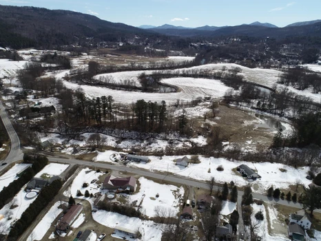
11/21/2024
$8,000,000
68.92 ac.
ACTIVE
Windsor County - 115 Eastman Road, South Woodstock, VT
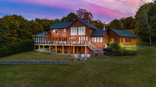
Sorgenfrei, or "Carefree," was built by Ennis Construction in 2015, and this extraordinary property truly embodies that sobriquet. A stunning and uncommon confluence of the finest materials and the most energy efficient techniques, this home was carefully constructed to maximize worry-free enjoyment. The most advanced systems and a focused commitment to the highest quality make this home a testament to elegant durability. From the mahogany exterior to the handcrafted front doors and custom-wrought iron hardware, this spacious and meticulously considered home celebrates the skill of Vermont's most talented craftspeople. The unparalleled 180-degree views over the Woodstock valley are spectacular in every season, offering year-round sunlight and ever-changing vistas. With a gourmet kitchen custom-built for entertaining, a 1,000-bottle wine cellar, and a double-sided great room fireplace, Sorgenfrei perfects conviviality. The measures taken to ensure the property’s efficiency and durability are too numerous to name - among them: an 18kw solar array, Pella Architect-Series windows, and custom mortise and tenon fir construction. At home among Woodstock's most lauded residences, and gorgeously situated in one of the area's most prestigious neighborhoods, this home is a testament to uncompromising vision and a paean to unparalleled enjoyment of Vermont's Green Mountains.

01/06/2026
$5,100,000
5225 ac.
ACTIVE
Essex County - East Haven, VT
LandVest is pleased to present Starr Mountain, a premier Vermont timberland ownership offering an exceptional opportunity for natural capital investment and long-term forest stewardship.
Located within the rolling green hills of the East Haven Range, Starr Mountain encompasses a large, contiguous acreage with favorable growing conditions and reliable access. The property benefits from a long history of professional, sustainable forest management, resulting in a high-quality mid-rotation hardwood resource complemented by meaningful softwood diversity.
A June 2025 timber inventory indicates a well-stocked forest carrying 4.7 MBF of sawtimber (sawlogs and tie/pallet) and 15.2 cords of pulpwood, with an average stocking level of 24.5 gross cords per forested acre. The species composition is led by sugar maple, yellow birch, and spruce/fir, positioning the forest for continued biological growth and value appreciation.
The property offers multiple avenues for near- and long-term returns, including selective silvicultural harvests, carbon sequestration opportunities, and recreational leasing. A Forest Legacy conservation easement protects the land for ongoing timber production and recreation while allowing for active, flexible forest management.
Starr Mountain enjoys access to regional pulpwood and sawtimber markets and is enrolled in Vermonts Use Value Appraisal (UVA) program, providing favorable property tax treatment.
This offering represents a rare opportunity to acquire a large, single-tract timberland holding in the heart of Vermonts Northeast Kingdoma region known for its working forests, conservation ethic, and enduring land value.
Proximity:
Saint Johnsbury, VT 40 minutes
Hanover, NH 1.5 hours
Boston, MA 3.5 hours

11/14/2025
$695,000
19.47 ac.
ACTIVE
Lamoille County - 167 High Meadow Rd, Stowe, VT
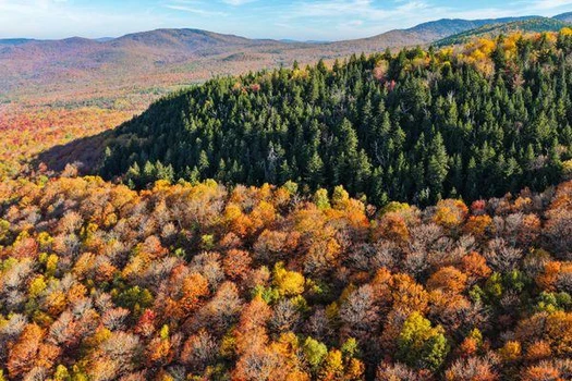
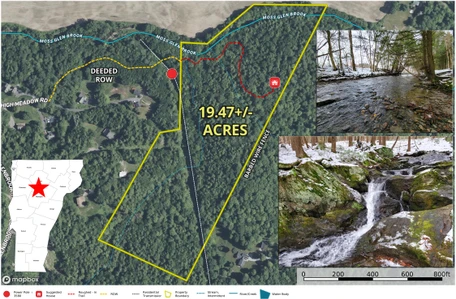
For the first time since 1984 the beautiful Majestic Falls Forest, located in the famous ski town of Stowe Vermont, is finally for sale. This expansive 19.47+/- acre woodland property sits above the VT-100 corridor with views of the valley farms to the north and Mt. Mansfield to the northwest. A very mature woodland is made up primarily of hemlock intermixed with maples and birch. Enjoy the wildlife as the deer move steadily through the property to feed in the abundant fields below. Two tributaries of the Moss Glen Brook flow gently through the property. The property is named for the incredible falls on the eastern tributary, 150+/- feet of beauty, rolling over large rock slabs and boulders. The driveway is a ROW that has been well marked and roughed in up to one of the potential home sites. Two stream crossings will be required and there is a small pond at the entrance to the property. Conveniently, a residential power line runs on the west edge of the property greatly simplifying utility access. The ROW is accessed from the end of a very nice residential neighborhood whose roads are plowed and maintained by the town. The land is gently rolling with many potential areas for a home or homes. The seller does have a preliminary 5 lot subdivision plan from the 80's that can be provided along with soil test pit results. Stowe is well known for its year-round recreation, shopping, events and the Stowe Ski Resort. An amazing opportunity to create your private estate.


01/17/2026
$1,250,000
93.4 ac.
ACTIVE
Rutland County - 96 Tabor Road, Shrewsbury, VT
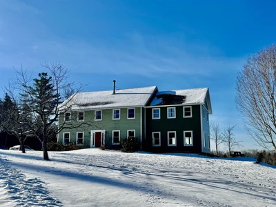
Set amid sweeping mountain views, open meadows, and forested trails at the peaceful end of Tabor Road, this 93.4 acre Shrewsbury retreat captures the essence of Vermont living: private, expansive, and deeply restorative. The landscape is the defining feature - open fields, wooded paths, and three ponds, including a hidden gem tucked awaydown a wooded trail that suddenly opens into a wide clearing. It’s a setting that invites exploration, reflection, and four-season enjoyment, all within easy reach of the Okemo and Killington ski areas and the year-round Rutland amenities. The residence combines the ease of more modern construction with the warmth and scale of a home designed for gathering. A recent 2-story addition expanded the layout to 6 bedrooms and 3 baths. Designed with future expansion in mind, the second floor includes roughed-in plumbing for an additional bath. The open kitchen with cherry cabinetry and stainless appliances flows naturally to the dining area and living room anchored by a wood stove. A light-filled first-floor bonus room with radiant heat and oversized windows frames sweeping mountain range views and offers an inviting space for relaxation, work, or play. With over 3,500 sq ft of finished space, plus an unfinished walkout basement with overhead garage door and attic storage, the home supports a wide range of lifestyles. Outdoors, miles of trails wind through fields and forest, connecting the ponds, perennial gardens, fruit trees, grape vines, and broad open areas. The acreage spans 3 subdivided parcels, with 82 acres enrolled in Vermont’s Current Use program for property tax advantages. Additional features include a multi-bay car barn, chicken coop, greenhouse, wood-fired stone pizza oven, 3-sided shed, automatic generator, central vacuum, and wiring for a hot tub. A distinctive Vermont retreat offering space, privacy, and ready-made outdoor lifestyle well suited for full-time living, a second home, or elevated four-season vacation home.
Copyright © 2026 PrimeMLS. All rights reserved. All information provided by the listing agent/broker is deemed reliable but is not guaranteed and should be independently verified.


08/31/2025
$1,950,000
97 ac.
ACTIVE
Rutland County - 1204 Bailey Road, Shrewsbury, VT
Welcome to Salt Ash Farm, a secluded treasure in the hills of Vermont on 97 +/- acres. This incredible 6 bedroom, 5 bath home has been thoughtfully expanded and updated over the years and offers a unique blend of classic, rustic and contemporary features. The aura that resonates is peace and tranquility. A spacious well-appointed kitchen has floor to ceiling windows to take in the majestic view. Just off the kitchen is a very cozy “keeping” room with a large fireplace perfect for relaxing after a day of skiing. A calming sunroom leads to a light-filled great room overlooking the pasture, woodlands and beyond. The second floor features a primary bedroom with exposed brick hearth and walk-in closets. Additional bedrooms and baths, a study and a sauna, accommodate family and guests superbly. Across the road, there is a cool tiny house, artfully fashioned from a former milk house. The gambrel-style two-story pre-war barn has been transformed into an event space and has hosted weddings and gatherings for all occasions! The inviting spring fed-pond has a dock for swimming or a lively game of ball with the dogs. Stone walls, open vistas and space to meditate all renew the soul. Okemo/Jackson Gore is a stress-free 12 min. drive away. High speed fiber optics allow you to work remotely while enjoying the best of both worlds. The future stewards of this property will enjoy discovering the many aspects and possibilities of this special Vermont retreat.
Copyright © 2025 PrimeMLS. All rights reserved. All information provided by the listing agent/broker is deemed reliable but is not guaranteed and should be independently verified.

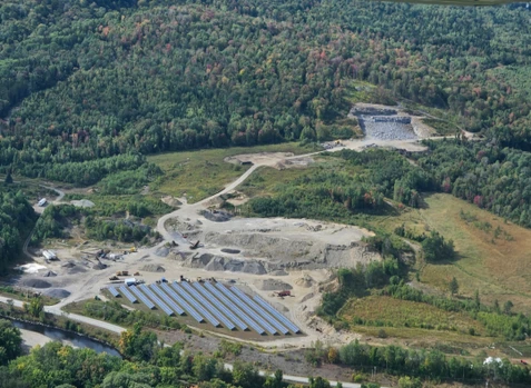
12/09/2025
$20,000,000
260 ac.
ACTIVE
Essex County - 6489 Vermont 102, Lemington, VT
Operating Aggregate business in Northern Vermont and New Hampshire. 3 Gravel pits located in Essex County, Vermont and 1 located in Coos County New Hampshire all along the Connecticut River, producing ledge, gravel and sand. Will come with 3 solar panel leases, 2 workshops, scale and scale house and all heavy equipment. Price and equipment negotiable.

08/28/2025
$139,000
34 ac.
ACTIVE
Caledonia County - Denio Road, Barnet, VT
The Valley View Parcels are four separate pieces of land in Barnet, Vermont. The best use for these parcels are as homesites with excellent four-season road frontage. Electricity is available on Denio Road for Parcels 1, 2, and 3. Electricity for Parcel 4 on Comerford Dam Road can be brought in from the Denio Road intersection, approximately 400 feet away. Each property has open clearings, and there are multiple options for home sites on Parcels 1, 2, and 4. Parcel 3 is suitable for one home. Views are found on each property, with Parcel 1 having winter views of the White Mountain Range. Additional views on these parcels could be opened up with additional tree thinning.
These northeast kingdom properties are situated above the Connecticut River and close to the towns of Barnet, Peachem, Groton, and St. Johnsbury, VT. Local four-season amenities are abundant. Pine Grove Park at Comerford Dam Lake, with picnic, boat launch, fishing, and swimming facilities, is 1.5 miles away. Harvey's Lake beach is six miles away, and there are three Vast trails for snowmobiling close by. Skiing at Burke Mountain, Loon Mountain, and Bretton Woods is within 30 to 40 miles. The larger town of Littleton, NH, which is the gateway to the White Mountain National Forest, is located on the other side of the river. Groton State Forest is less than 30 minutes away, and is a 26,000-Acre state forest noted for its scenic natural beauty and open land for hunting, fishing, snowmobiling, and many other outdoor recreational activities.
Interstate highway access is excellent, as the parcels are only 5.5 miles from Exit 18 off I-91. Boston, Massachusetts, and Montreal, Canada, are two and a half hours away, Hartford, Connecticut, is less than three hours away, and New York City is five hours away. Local access is provided by four-season Class III roads with extensive direct frontage on Denio and Comerford Dam Road.
This 34-acre parcel is located on Comerford Dam Road. There is a well-situated, large, open clearing with an existing driveway that would be an easy place to build a home. There are two additional cleared home sites, making this parcel an ideal family compound, or optionally, the homesites could be subdivided and sold. There is electricity approximately 400 feet from the property at the intersection of Comerford Dam Road and Denio Road. The eastern and southern views could be further opened with additional tree thinning. A year-round stream bisects the property, providing both dramatic views and wildlife viewing as animals drink from the stream. There are extensive high-quality sand deposits for on-site construction activities. This parcel is ready for your home or camp with different places to build available. Excellent road frontage, views to the southeast, with amenities and outdoor recreation nearby make this property a great piece of land to consider.


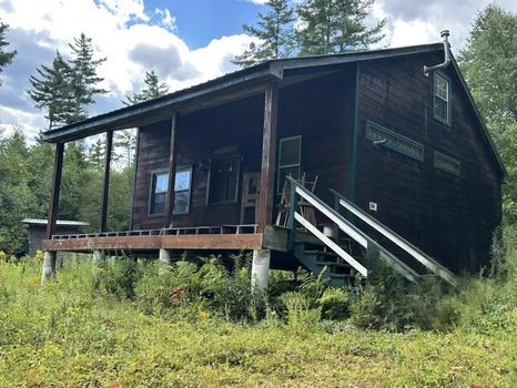
10/22/2025
$595,000
238 ac.
ACTIVE
Essex County - 501 Fellows Road, Guildhall, VT
The Mountain View Cabin offers a secluded retreat perfect for those seeking modern amenities mixed with rural charm and outdoor recreational opportunities. The property features:
-A newly constructed cabin with off-grid power, kitchen/living space, and loft
-Expansive views of New Hampshire's Presidential Range
-Newly constructed driveway leading from Fellows Road, a public Class 3 highway close to Vt-102
-Professionally constructed Atv/Recreational trails throughout the forest
-Mixed timber resource offering future value appreciation
-Direct access to Vast snowmobile trails, with ATV trails located nearby
The Mountain View Cabin is located in quaint Guildhall, Vermont, just west of the border between Vermont and New Hampshire. Just east, the Connecticut River forms the state line and offers fishing and paddling opportunities, especially on the Northern Forest Canoe Trail, which winds from Old Forge, NY, to Fort Kent, ME. The surrounding landscape on the Vermont side is primarily forested, with thousands of acres of public or publicly-accessible forests, trails, and roads available for exploration. Surrounding development is limited, with only scattered homes and camps dotting the landscape and featuring small farms in the valley areas. In New Hampshire, only a short drive away, the town of Lancaster contains many local and unique amenities, including dining, a brewery, shops, a theater, and emergency services. Only 12 minutes away, the Gateway to the Great North Woods ensures access to services when needed.
The property is well-situated for the outdoor enthusiast. Vermont and New Hampshire snowmobile and ATV trails are nearby to the south and north, with a Vast snowmobile trail crossing the property to the south. Kingdom Heritage Conservation Lands (Vt) to the west provides ample opportunities for hiking, biking, fishing, hunting, and exploration, while in New Hampshire, the White Mountain National Forest is found only slightly east of Lancaster. To the north, the Great North Woods of Pittsburg offers many of the same opportunities. For investors, the property offers great potential for short-term rental to outdoorspeople seeking these activities.
Burke Mountain, a renowned destination for mountain biking and alpine skiing, is located 22 miles to the west, about a 45-minute drive along the scenic Granby Road. The Bretton Woods Ski Area and Mount Washington, home to the famous Tuckerman's Ravine and scenic toll road, are just 29 miles to the south. The property is just minutes from Us-2 and Us-3, serving destinations in all directions. Burlington, VT, is approximately 2.25 hours away. Travelers from Boston, MA, and Portland, ME can expect a 3.5-Hour journey.
Access to the property is easily found from Fellows Road, a maintained Class 3 public road originating from Vt-102. From here, a recently-built gravel driveway winds 0.67 miles until reaching the height of land, the pole barn, and the camp. Both Fellows Road and the driveway are suitable for all vehicles.
Along with the camp, the property features 238 acres of scenic forestland, mostly hardwood timber, although with softwood included in certain stands. The forest is generally young, having been logged around 30-40 years ago, but has since regenerated with small pole-sized hardwood timber. Certain areas were not harvested and boast more mature growing stock. The species mix is predominated by maples, ash, birch, and beech, representing a typical Vermont hardwood species mix. The property is well placed for future asset appreciation as these stems grow into sawlog classes.
A main feature of the property is the extensive trail network, some of which is professionally constructed, which allows easy access to all areas of the property for powersports riding, hiking, hunting, dog walking, skiing, and mountain biking. Trails have been maintained by the landowner over the years and are ready for immediate use. Due to the mixture of forest species and age classes, wildlife signs of moose, deer, bear, and partridge are easily found in the forest. Located in WMU E2, short-term rental investors may find demand from hunters and anglers looking to explore the North Woods.
Perched on a hillside overlooking the Presidential Range of the White Mountains, the Mountain View Cabin combines modern amenities with long-range views and a deep-woods ambiance. This charming retreat boasts multiple entrances from front and rear porches, inviting guests to transition between the outdoors and the cozy interior. Powered by an eco-friendly solar array and equipped with reliable battery storage, the cabin not only promises sustainable living but also allows you to fully embrace the peaceful surroundings. Enjoy breathtaking sunrises and sunsets from your expansive porches, where you can unwind and savor the deep-woods ambiance that makes this property truly special.
Step into this charming cabin and experience the perfect blend of rustic charm and modern convenience. The inviting mudroom/living room area is not only a cozy gathering space but can also easily transform into a comfortable extra bedroom for your guests. The bright and airy kitchen/dining area features a propane cooktop, sink, and sliding-glass door to the front porch. Upstairs, the loft serves as the primary bedroom, offering a peaceful retreat with scenic vistas. This charming cabin combines comfort and functionality with the benefits of solar power and battery storage.

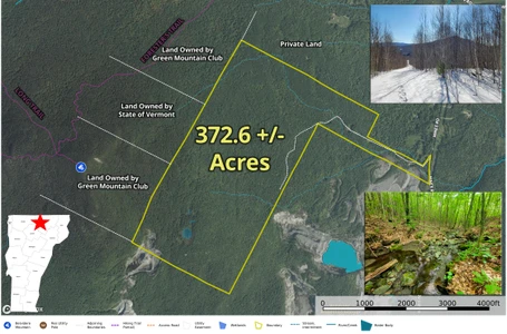
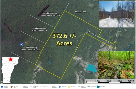
03/20/2026
$300,000
372.6 ac.
ACTIVE
Orleans County - 4166 Mines Rd, Lowell, VT
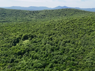
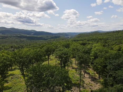
Discover the ultimate 372.6 +/- acre recreational retreat in Lowell, VT, nestled against conserved land near the peak of Belvidere Mountain. Journey along a half-mile access roadeasily navigable by 4x4 or ATV from the paved, town-maintained Mines Roadto a private 0.28 +/- acre clearing perfectly suited for a secluded seasonal camp featuring mountain and ridgeline views. This is a true haven for backcountry skiers, hikers, mountain hunters, and remote campers. Boasting a gentle to moderate sloping topography, the forestland features a beautiful hardwood canopy, several year-round streams, abundant wildlife, and an old logging network ready to be reclaimed into an extensive private trail system. Adventure awaits just 1,500 feet from the western boundary, where the Green Mountain Club's Forester's Trail connects to the Long Trail and the Belvidere Mountain fire tower. With excellent southern exposure and industrial power at the street, there is potential for solar development, while the expansive hardwoods invite exploration for future sugaring operations. Access is secured via a short, deeded right-of-way. Please note the property slopes toward an abutting, discontinued long-strain asbestos mine. Additional documentation is available; the provided address is for GPS purposes only. Bring your vision and create your ultimate backcountry escape!

09/08/2025
$261,000
130 ac.
ACTIVE
Essex County - 955 Hall Road, Lunenburg, VT
Located in rural Lunenburg, Vermont, this property offers the perfect blend of access to local amenities with the seclusion of Northeast Kingdom forestlands. The surrounding landscape is one of vast, undeveloped timberlands, mixed with well-maintained camps off Hall Road, which also serves as an ATV and snowmobile trail. Property highlights include:
-Standing timber value of $140,500, with a promising timber asset appreciation outlook
-Attractive forest conditions, with minimal low shrubs and regeneration creating easy walking conditions
-Developed access off Hall Road, with a built driveway (right-of-way) accessing potential camp sites
-Mostly gentle terrain with trails ready to be upgraded
Location
The forest is located in the town of Lunenburg, in the Northeast Kingdom, which borders New Hampshire and the Connecticut River. Much of the area is rural and characterized by a heavily forested landscape, with homes generally scattered, except for clusters found in small hamlets and along Neal Pond. Small farms along the Connecticut River are also prominent, contributing to the region's traditional working-land character. The landscape to the north is almost entirely forested and includes several larger timberland blocks under both private and public ownership. Neal Pond is a short distance to the south and features a public launch for fishing and boating. Lunenburg Village lies just 5.5 miles from the property via Route 2. The village offers a convenience store, post office, elementary school, and town municipal offices. The drive to the village along Pond Road passes occasional year-round homes, while the immediate Hall Road area is known for its numerous seasonal camps.
Lancaster, New Hampshire, is the closest major town, located about 10 miles east along the Connecticut and Israel Rivers. Lancaster serves as a regional hub with a vibrant downtown, offering full amenities and earning the reputation of the Gateway to the Great North Woods. The town can be found bordering the scenic, rolling mountains of the Kilkenny Range within the White Mountain National Forest. For broader regional access, Boston and Portland, Maine, are approximately a 2.5-Hour drive to the south and southeast. There are sites available for potential camp-building near the existing cleared log landing or at several other locations throughout the forest.
Access
The property can be accessed via Hall Road, which is a Class 4 town road. This is followed by a legally deeded 50-foot-wide right-of-way (Row) that provides direct access to the property, stretching approximately 1,100 feet.
Although Hall Road is not maintained by the town and is not plowed during the winter months, nearby camp owners routinely maintain the road, ensuring it remains passable. During the winter, Hall Road serves as a significant Vast snowmobile trail.
Property Description
The land is primarily characterized by gentle slopes, with some steeper sections forming a hillside that faces southwest. The elevation ranges from approximately 1,620 feet above sea level (Asl) in the east, where a log landing and potential campsite locations are found, to about 1,940 feet ASL at the height of land to the north. A small stream drains this hillside, flowing southwest and eventually forming Hall Brook, which empties into the Connecticut River to the west.
The ground conditions and slopes are favorable for timber harvesting and recreational activities, with very little difficult terrain limiting access. Some areas of the property are upland and quite dry, while other regions to the west contain more softwood timber and riparian zones, providing excellent wildlife habitat.
Forest trails, created from previous logging activities, can be found throughout the property, offering access for off-trail snowmobiling, ATV riding, hunting, and hiking. Hall Road itself serves as a Vast Snowmobile Trail during the winter months, providing access to major trails leading to points of interest in Vermont and New Hampshire. There are several potential camping sites available near the existing cleared log landing and at various points throughout the forest.
Timber Resource
Timber data in this report is based on a comprehensive timber inventory completed in June of 2023 to establish Capital Timber Value (Ctv), then grown forward two growing seasons using current FIA growth data. Thirty-six inventory points (1 plot per 3.6 forested acres) were sampled, covering a 415' x 415' grid using a 15-factor prism. Sampling statistics are 30% standard error for sawlog products and 13.7% for all products combined at the 95% confidence interval.
The timber data revealed a total sawlog volume of 481 MBF International scale (3.7 Mbf/Acre), with 2,751 pulpwood cords (21 cords/acre). The combined total commercial per-acre volume is 28.4 cords, a figure above average for the region. Stumpage values were assigned to the volumes in August 2025, producing a property-wide Capital Timber Value (Ctv) of $140,500 ($1,072/Acre). See the Timber Valuation in this report for details.
Species Composition
Hardwoods dominate the species composition, accounting for 89% of the total volume, while softwoods make up 12%. The overall mix closely mirrors that of the surrounding region, with sugar maple comprising 47% of the total volume, followed by red spruce (32%), white ash (8%), yellow birch (6%), black cherry (3%), and miscellaneous hardwoods.
The sawlog volume breakdown reflects strong market demand, led by sugar maple, yellow birch, white ash, spruce/fir, white birch, aspen, and black cherry. A notable attribute is the limited presence of beech in both the overstory and understory.
Sawlog Value
Sawlog value is concentrated in sugar maple (53%), red spruce (28%), white ash (11%), and yellow birch (4%), with the balance in miscellaneous species.
Diameter Distribution
The average diameter for all products combined is 11.1 inches, while sawlogs average 11.7 inches. Sugar maple, the dominant species, averages 13.0 inches. Overall, the forest consists of two primary age classes: an older cohort, roughly 70 years old and scattered throughout the property, and a younger cohort established about 35 years ago following a heavy harvest.
Stocking & Stem Quality
Fully stocked stands represent forest density. The average basal area (Ba) is around 97 ft on 296 stems per acre. Stem quality is well above average for the region, with acceptable growing stock BA at 81 ft. The younger age class is high in density, with straight, clean, and tall stems perfectly positioned for future asset appreciation and for shifting products to higher-value sawlogs and veneer. The older age class represents a strong income opportunity the next time the property is silviculturally treated.

08/28/2025
$315,000
127 ac.
ACTIVE
Caledonia County - Denio Road, Barnet, VT
Property Overview
The Valley View Parcels are four separate pieces of land in Barnet, Vermont. The best use for these parcels are as homesites with excellent four-season road frontage. Electricity is available on Denio Road for Parcels 1, 2, and 3. Electricity for Parcel 4 on Comerford Dam Road can be brought in from the Denio Road intersection, approximately 400 feet away. Each property has open clearings, and there are multiple options for home sites on Parcels 1, 2, and 4. Parcel 3 is suitable for one home. Views are found on each property, with Parcel 1 having winter views of the White Mountain Range. Additional views on these parcels could be opened up with additional tree thinning.
Location
These northeast kingdom properties are situated above the Connecticut River and close to the towns of Barnet, Peachem, Groton, and St. Johnsbury, VT. Local four-season amenities are abundant. Pine Grove Park at Comerford Dam Lake, with picnic, boat launch, fishing, and swimming facilities, is 1.5 miles away. Harvey's Lake beach is six miles away, and there are three Vast trails for snowmobiling close by. Skiing at Burke Mountain, Loon Mountain, and Bretton Woods is within 30 to 40 miles. The larger town of Littleton, NH, which is the gateway to the White Mountain National Forest, is located on the other side of the river. Groton State Forest is less than 30 minutes away, and is a 26,000-Acre state forest noted for its scenic natural beauty and open land for hunting, fishing, snowmobiling, and many other outdoor recreational activities.
Access
Interstate highway access is excellent, as the parcels are only 5.5 miles from Exit 18 off I-91. Boston, Massachusetts, and Montreal, Canada, are two and a half hours away, Hartford, Connecticut, is less than three hours away, and New York City is five hours away. Local access is provided by four-season Class III roads with extensive direct frontage on Denio and Comerford Dam Road. Note: There is a utility easement on Parcel 1 from the 1950S that was never built, as the power lines from the hydro dam were installed lower down on Comerford Dam Road.
Property Description
This parcel is 127 acres, and the best place to build a home is on Denio Road, where power is available. From this parcel, there are views of Mount Washington and the Presidential Range through the trees, and southwest views down the Connecticut River valley. The access on Denio Road leads to a semi-opened park-like setting with large oak trees as the main species on that part of the land. There are sections of white pine, hemlock, and other northern hardwood species on the rest of the property. Due to past logging activity, walking through the parcel is excellent, making it easy to explore this large parcel. A small stream leads from the upper part of the property to the lower section. There are gravel deposits available for on-site construction activities. If you're in the market for a large parcel with year-round road access, multiple homesite options, trails, views, amenities, and four-season outdoor recreation nearby, this parcel is an excellent option.


07/21/2024
$705,375
515 ac.
ACTIVE
Orange County - Powder Spring Road, Topsham, VT
The property features opportunities to take over an attractive, long-term investment, which has been well-managed over time for high-quality northern hardwood timber. Potential building sites can also be easily found throughout the land.
Notable highlights include:
- Managed timber resource, well-positioned for future volume and value growth;
- Sugar maple-dominated timber resource worth around $579,300;
- Sugarbush management and development potential, owing to 40% stocking of sugar maple and excellent slopes;
- Developed internal forest road access;
- Desirable location in central Vermont, close to population centers such as Barre and Montpelier, and close to Interstate 91.
Location
Powder Spring Forest is located in north Topsham, Vermont, a rural town in Orange County mostly consisting of forested acreage, farms, and small homesteads. The town is situated just east of the Green Mountains and west of the Connecticut River Valley, characterized by rolling hillslopes and many rivers, including the Waits, which drains east into the Connecticut River, and the Powder Spring brook, from which this forest gets its name.
While Topsham exemplifies the character of rural Vermont, with its peaceful ambiance and quaint rural character, the town and the subject property are easily connected to local population centers and amenities. Vermont Route 25 and U.S. Route 302 serve to connect Topsham with Barre to the northwest (25 miles away), Bradford (12 miles away to the southeast), and St. Johnsbury (31 miles northeast). In Bradford, there is access to Interstate 91, a major travel corridor connecting Vermont to Massachusetts and Canada, and in Barre, there is access to Interstate 89, connecting to major cities and cultural centers of Burlington, VT, and Manchester, NH. Boston, MA, and Hartford, CT, are a 3-hour drive south.
Access
Legal access to Powder Springs Forest is provided by several modes, including Town Class 3 & 4 roads and private access points.
Powder Spring Road provides a point of access to an old woods road that parallels the brook. This former roadway provides sufficient access to the lands extreme eastern slopes as they tilt to the brook. This small region of the forest supports an attractive 35 to 45-year-old sugar maple stand.
Sanborn Road offers frontage for a driveway point permitting access to another small section of the forest which slopes to the east.
Currier Road is the primary access point to the forest, which leads to a 1,600 section of class 4 road before entering the southern section of the property. Once on the property, a developed internal road runs 2,600 to a log landing which provides access to all of the propertys western higher elevation. Another internal road runs nearly 3,600 to the east and then north, providing functional access to the lands entire eastern half. Both roads can be seen on the property photo maps.
Frost Road provides legal Class 4 access to a small section of the northern end of the property. However, this area has traditionally been accessed from the established roads that originate on the southern side of the forest.
Site Description
The property has been shaped by its former uses, including an intensive period of farming and homesteading going as far back as the late 1700s. Field evidence, such as barn and house stone foundations, stone walls ,and wire fences, covers the propertys landscape, indicating that nearly all of the land was formally used for some form of agricultural activity. Following abandonment in the late 1800s, as the country grew more industrialized, the farmlands were steadily abandoned and allowed to grow back to forest.
The property is situated in a generally high-elevation region of Vermont. The land is characterized by several hills, ravines, and drainages which offer aspects in all directions. The southern and eastern-facing hillsides especially would benefit from tree clearing in order to maximize potential views, which would offer vistas of the White Mountains to the east. Elevation ranges from around 1,500 near Powder Springs Road, where the land rises up a prominent hillside (1,900) before falling again to the west, where flatter land contains wetlands and low-lying creeks. Headwater streams of Powder Springs Brook are found here, running through the property heading south.
Slope conditions on the property are rolling and moderate overall, and the terrain is easily accessible by foot or via logging equipment during forest management.
Timber
Timber data in this report are based on a timber inventory conducted in December 2022, with the purpose of establishing Capital Timber Value (CTV) by F&W Forestry Services, the owners forest manager. 91 inventory points were sampled (1 plot per 5.4 acres), covering a 486 X 486 grid using a 15-factor prism. Sampling statistics are 13.4% standard error for sawlog products and +/-7% for all products combined at the 95% confidence interval. Upon applying growth for 1 season at regional FIA data growth rates, the timber data reveal a total sawlog volume of 2,243 MBF (Intl scale) (4.4 MBF/acre), with 6,435 pulpwood cords (13.0 cords/acre). Combined total commercial per acre volume is 18 cords, a figure about average for the region. Stumpage values were assigned to the volumes in May of 2024, producing a property-wide Capital Timber Value (CTV) of $566,100 ($1,143/acre). See the Timber Valuation in this report for details.
Species Composition:
The species composition is 84% hardwoods and 16% softwoods. Species composition for all products combined is led by sugar maple (44%), followed by yellow birch (12%), white ash (9%), and red maple (8%). Softwood volume mainly consists of spruce/fir (8%) and pine (3%). Scattered red pine is also found in some areas of the forest. The sawlog volume breakdown is led by sugar maple (46%), followed by spruce/fir (14%), and yellow birch (13%), along with small levels of various common associates. The primary species all have benefited from strong historical (and current) markets for their various end products, ensuring the likelihood of robust asset appreciation from stumpage price growth.
Stocking and Stem Quality:
Stocking is variable due to past timber harvesting, which has targeted various areas of the property. Much of the property is found as mature, even-aged forest, while other acreage has been harvested and is now a less dense overstory growing atop a dense understory. Basal areas in the stands range from 40-120 ft2/ac, and show 69% Acceptable Growing Stock.
Sawlog Value/ Management History:
Sawlog value is dominated by sugar maple (46%) followed by spruce/fir (14%) and yellow birch (13%), with the small balance held by red maple, white ash, and others.
The 2023 forest management plan identifies fifteen forest stands. Most stands have been harvested in the past two decades using a combination of shelterwood, group selection, and overstory removal harvesting. The most recent harvesting on the property occurred in 2018.
Diameter Distribution:
The diameter distribution indicates a wide range, with strong representation from advanced saplings established during harvesting over the years. Poletimber in the 6-10 diameter range is also well-represented. The diameter distribution clearly shows the results of a managed forestland, with the bulk of the stocking being found in small logs and large poletimber nearing sawlog size.
Sugarbush Option
The timber data indicates a total of 16,400 potential maple taps from the 9 and greater size classes, with 84% of the taps from sugar maple and the balance red maple. Tap density per acre is variable, ranging from around 20 per acre in previously harvested areas to 60-70 in more dense hardwood stands. Sugaring use would be an excellent additional income source if portions of the property were given over to taps. Electrical power is available a short distance from the property on Currier Road or on the Powder Spring Road, and slopes offer a diverse aspects for multiple setup options.


09/23/2024
$237,000
221 ac.
ACTIVE
Orange County - New Boston Road, Thetford, VT
Introduction
The ownership is selling their property in two separate parcels, divided by the town line. The +/-60 acre Strafford parcel is well suited to future home development with paved town road frontage and roadside electric service. The +/-220 acre Thetford parcel is well suited to a camp or seasonal off-grid home development with beautiful local views.
Both parcels have significant frontage along the West Branch of the Ompompanoosuc River. Both parcels have Restricted Use Areas associated with the reclaimed Elizabeth Copper Mine site.
Location
The parcels are situated in east central Vermont, 11 miles from the New Hampshire border. The local landscape is dominated by abundant forestland, with small farms in the valleys and widely scattered homes along roads. This area is part of the West Branch of the Ompompanoosuc River watershed, a sizable river that runs along both parcels.
The hamlet of South Strafford is 1.7 miles to the northwest and is host to a general store. Norwich, Vermont, located 10 miles to the south, is the closest large town offering the most amenities. Interstate 91 is just east of Norwich, and across the Connecticut River is the Town of Hanover, host of Dartmouth College. Boston is just over a 2 hour drive.
Access
The land is accessed from New Boston Road, a graveled, town maintained road. There is no electric power along this part of the road. A +/-400 right of way road runs from the town road to the property boundary and gate. From the gate, a gravel road heads into the land in a northern direction for +/-2,325 to the lands open meadow and likely best camp location. From this point, the road continues through the land for another +/-3,950 (this last section of the road will need some maintenance before its drivable again; however, much of the road is graveled & ditched).
Site Description
The lands primary feature is its nearly 1/2 mile of river frontage at its northern end. Two old woods trails head to the river providing good access to this scenic water resource.
Given the lands access, distance to electric power, Restricted Use Area, and opposing solar array, the highest and best use is likely a camp/seasonal home development, recreation, and/or forest management. A meadow at the end of the access road (see maps for location) offers attractive views to the west and north, a prime location to develop a large camp or seasonal home. There is a small woodland pond near the field that contains amphibians such as newts and frogs, and would be used for drinking water by deer and other animals in the forest.
Elevations range from 730 along the river to 1,200 near the SE boundary. The terrain is mostly gently sloping, however, with steep terrain along the river.
Timber
The forest can be considered aesthetically scenic as it has been several decades since forest management has occurred, resulting in a high canopy thats easy to walk through. Generally, on the higher elevation and more level sites, northern hardwood species dominate. On the steeper slopes and along the river, dense hemlock stands are common, with large legacy trees throughout, holding diameters in the 18-24 size class. The hardwood stands have a range of diameters, are fully stocked, and include large legacy stems. The youngest age class was created from harvesting that occurred +/-24 years ago.
Solar Lease
Portions of the Restricted Area are occupied by a solar project operated by Greenwood Infrastructure, under a lease in which the lease period could remain for an additional +/-42 years. Annual lease income is $1.00. A copy of the lease agreement is available upon request.
Restricted Use Area
The property is part of the former Elizabeth Copper Mine whose reclamation and stabilization was finalized by the EPA. As part of EPAs reclamation/remedial action plan, the land includes a Restrictive Use Area covering a total of 79 acres as represented on the property maps and survey. This area can not be developed or disturbed in the future per the Grant of Environmental Restrictions, Right of Access, and Easement deed. Copy provided upon request.


07/08/2024
$359,000
88.5 ac.
ACTIVE
Washington County - Plunkton Road, Warren, VT
The property is well suited to buyers seeking to establish a large family compound in Warren with plenty of acreage to roam or, property developers aiming to subdivide and sell multiple homesite parcels (which the current zoning supports). The land abuts the Green Mountain National Forest, and is a short drive to Sugarbush Ski Resort, Blueberry Lake, and Warren Village.
Key property highlights include:
- Ideal home sites close to town road;
- 8 miles to Sugarbush Resort and 6 miles to Warren, Village
- Views of Mount Adams with tree clearing.
- Bordered on the west by Green Mountain National Forest & south by lands of the State of Vermont.
The property is situated along the southern end of Plunkton Road, a town road that leads north to the heart of Warrens scenic easterly highlands. The potential building sites are in an ideal location, very close to Route 100 and only 15 minutes from Sugarbush Resort. Blueberry Lake is walking distance up the road, where you can boat, swim or fish on a pristine, uncrowded lake. From the land, walking access is available to the adjacent Green Mountain National Forest, where tens of thousands of acres are available for recreational pursuits. Boston is three hours away, and New York City six hours. This area of central Vermont has much to offer, from restaurants and cultural amenities to outdoor pursuits. Burlington and Lake Champlain are an hours drive away.
Access can be considered excellent with +/-660 of frontage along Plunkton Road, a town-maintained, graveled road, with electric power and telephone services roadside. There is an existing old driveway cut into the land supporting a future internal road/driveway to support future home development.
The lands relatively high elevation (+/-1,600) provides attractive, potential views to the southeast of Mount Adams, a nearby peak with elevation of 3,180 which lies along the Northfield Range, also in view with tree clearing.
The potential homesites offer an easterly to southeastern aspect covering gently sloping land with a few moderate slopes in between gentle benches. Soils in this area appears to be somewhat well drained. One of two possible old driveways can be used to access these potential homesites, one off Plunkton Road and one off the beginning of Southview Road (see maps for location).
The northeastern corner of the land is relatively flat supporting tall softwood trees on variable soil conditions with some wet areas. The west central area is the highpoint with elevation of 1,700 with a walking trail leading to the site. From this point south the land falls off covering variable terrain with rock out-crops in many areas creating an attractive hiking destination.
One year round stream runs along the southeastern boundary. Another small steam drains through the land creating small pools and tiny falls. The southern boundary runs along the Warren/Granville town line with Route 100 +/-300 from the southern boundary.
Forest aesthetics for the property can be considered highly attractive given the older age classes and dense overstory canopy, however in the northwest area, a dense understory exists given the nature of the mostly softwood species composition which can thrive in semi-light conditions. The western and south hardwood stand is mature with large trees while the area near the potential homesites has younger trees.
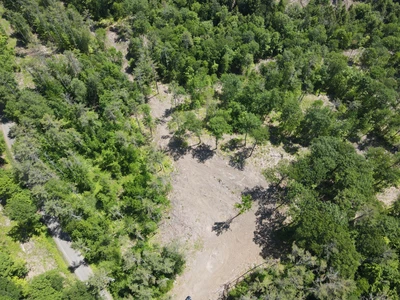
03/20/2026
$5,650
2.8 ac.
ACTIVE
Rutland County - 201W Vermont 3, Proctor, VT
Located in the quiet countryside of Florence, Vermont, this 2.8-acre wooded parcel offers a peaceful natural setting surrounded by Vermonts scenic landscape. The property features mature trees, wetlands, and a small stream influenced by local wildlife, creating a private environment for those who appreciate nature.
According to the town, the lot is largely classified as Class II wetland and wetland buffer under Vermont Wetland Rules. Because of this, development opportunities may be limited, and permits for structures, septic, wells, or driveways may be difficult or costly to obtain. Buyers should conduct their own due diligence with local and state authorities regarding potential uses and permitting requirements.
The property is located along VT Route 3 and is just minutes from Pittsford, with Rutland and other nearby towns providing access to shopping, dining, and outdoor recreation. This parcel may be best suited for buyers seeking a real Vermont address, conservation use, or a long-term land investment.


09/16/2025
$275,000
22.32 ac.
ACTIVE
Windham County - 81 Parish Hill Road # 26, South Newfane, VT
Tucked away in the quiet hills of South Newfane, Vermont, this property presents an excellent opportunity to own a secluded off-grid retreat with endless potential. Spanning 22.32 acres of mixed timberland, the land offers both natural beauty and outdoor recreation, while the cabin provides a comfortable base that is already well on its way to completion.The cabin itself measures 715 square feet and is approximately 80% finished, giving the next owner a chance to personalize the remaining work to their taste and style. Built with a metal roof for long-lasting protection, the structure is also insulated, making it suitable for year-round use once complete. Inside, youll find key systems already in place, including a wood stove, propane heater, solar power setup, and hot water system. These features combine to provide the comfort and convenience needed for extended stays in the woods, whether during hunting season, summer getaways, or a longer-term off-grid lifestyle.The cabin includes a covered front porch, perfect for sitting out in the early morning or unwinding at the end of the day while listening to the surrounding forest and the sound of a creek that runs through the property. Just steps away, a two-bay storage shed provides plenty of space for tools, firewood, or recreational equipment. A gated driveway ensures privacy and security as you arrive at your destination.For the outdoorsman, this acreage holds whitetail deer and wild turkey, creating excellent hunting opportunities right outside the cabin door. The diverse timberland habitat supports a wide range of wildlife, while also offering hiking, exploring, and the simple enjoyment of being immersed in nature.Whether youre looking for a seasonal hunting camp, a weekend retreat, or the foundation for a more self-sufficient lifestyle, this South Newfane property checks all the boxes. With the hard work already done and just the finishing touches left, it offers both immediate usability and the opportunity to customize it into your dream Vermont getaway.


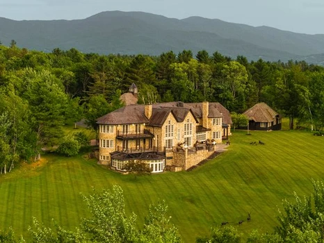
07/28/2025
$20,000,000
110.6 ac.
ACTIVE
Lamoille County - 2575 Weeks Hill Rd, Stowe, VT
Holistically designed and meticulously crafted in the style of a European country estate, Pristine Meadow is one of New England's most spectacular properties. Perfectly sited on 110 park-like acres, this bucolic setting sits remarkably in the heart of Stowe. Composed of gently rolling hills, meadows, woodland, a swimming pond, walking and skiing trails, and breathtaking vistas, this quintessential estate provides the utmost privacy. This 14,000 sf exquisite residence features six bedrooms and ten baths, highlighted by Italian-inspired interiors, imported materials, and magnificent architectural millwork throughout.The symbiosis of design and functionality is exemplified by the great room, which is simultaneously grand and comfortable. The state-of-the-art Boffi kitchen includes top appliances, custom cabinetry, a concealed walk-in pantry, and a charming breakfast room complete with a fireplace and solarium. A classical wood-paneled study with a wet bar sits just off the main dining room. The second-level primary suite affords dramatic views, large spa-like baths, and dressing rooms for both occupants. The guest suite is equal in its design. Three additional ensuite bedrooms perfectly complete the main sleeping quarters. An ideal guest apartment lies adjacent to the second floor with its own entrance and lock-off.Perhaps the finest example of Italian craftsmanship is the indoor pool constructed with hand-laid tile and beautiful travertine, evoking a true spa experience at an Italian palazzo. A fitness room, climate-controlled wine cellar, and laundry room round out the lower level.Not to be understated are the four-bay garage, car or implement barn, and a lovely unfinished cottage that could serve as additional guest quarters, an artist studio, workshop, or offices. Though no detail is spared, the splendor of this property and design execution can only be realized on-site and in person.

10/11/2025
$1,250,000
284 ac.
ACTIVE
Chittenden County - 0 North Road, Lot#WP001, Milton, VT
284 Acres With Buildable Land, Sugaring Potential, and Hunting Opportunities. Located in the heart of Chittenden County, this expansive 284-acre property in Milton offers an incredible blend of recreation, investment potential, and natural beauty. With a diverse landscape of mature timber stands, rolling meadows, and abundant wildlife habitat, this tract provides endless opportunities for outdoor enthusiasts and land stewards alike. The property features a healthy population of maple trees, offering excellent potential for sugar making. A current forest management plan is in place, and the land is enrolled in Vermonts Current Use Program, ensuring both responsible stewardship and tax savings for the new owner. The property has also been professionally surveyed, giving buyers peace of mind about boundaries and acreage. For those seeking recreation, the acreage is a dream come true. Established trails and open meadows make it ideal for riding ATVs, hiking, or exploring on foot. The mix of woods and fields creates excellent habitat for whitetail deer, turkeys, and various other game species, making it a prime hunting destination. Its combination of hardwoods and open spaces makes it a property designed to be enjoyed year-round. Convenience is another major advantage. Situated close to Interstate 89, Arrowhead Mountain Lake, and the Lamoille River, the property provides quick access to fishing, boating, and other water activities. Lake Champlain is just 20 minutes away, and the nearby towns of Milton, Georgia, and St. Albans offer all the essential amenities. Burlington is within easy commuting distance, making this an ideal location for both a private retreat and long-term investment. With 784 feet (+/-) of road frontage and the potential to build, the possibilities are wide open. Whether youre looking to establish a family retreat, start a sugaring operation, or simply enjoy the peace and privacy of a large tract, this Vermont property delivers. Dont miss the chance to own a rare piece of land that combines recreation, investment value, and location in one outstanding package.


05/24/2025
$750,000
76.09 ac.
ACTIVE
Rutland County - 603 Anderson Dr, Hubbardton, VT
Off-grid lakefront retreat with development and recreation potential Hubbardton, Vermont. Escape to your own piece of Vermont wilderness with this rare off-the-grid seasonal cabin nestled on the shores of Lake Hortonia. Boasting over 1,500 feet of private lake frontage, this serene property offers breathtaking views and a deep connection to nature. Whether youre casting for pike and bass in the clear waters or listening to loons at sunset, this is lake living at its most peaceful. The rustic cabin is powered in part by a solar system, providing eco-friendly energy for essential appliances. Surrounded by rolling woods and trails, the property offers prime hunting for deer, turkey, bear, small game and exceptional waterfowl opportunities around a scenic beaver pond. ATV trails run throughout, making it easy to explore all corners of the land. Outdoor enthusiasts and investors alike will appreciate the 4000 maple taps, presenting a unique income opportunity through maple sugaring. With the property previously formerly divided into seven separate lots, each with a deeded right of way, theres also the potential to expand with additional camps or cabins along the lake or deeper into the acreage. Situated just 2 miles from Lake Bomoseen and a short drive to Half Moon State Park, the location balances privacy with access to Vermonts beloved outdoor attractions. This is more than a campits a recreational haven, investment property, and legacy opportunity rolled into one. Whether you're seeking solitude, sport, or stewardship, this Lake Hortonia gem offers unmatched potential in a truly wild setting.
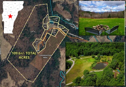
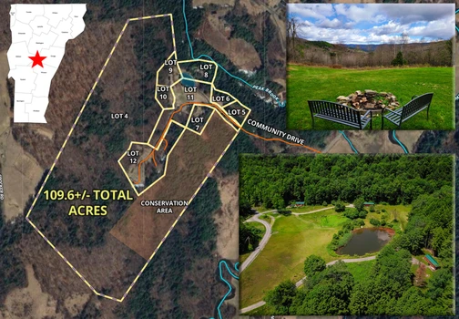
11/21/2025
$1,500,000
109.6 ac.
ACTIVE
Orange County - 250-566 Community Dr, Randolph, VT
109.6 +/- Acre, 9 lot subdivision offering a fantastic year-round AirBnB/Rental Tiny Home Investment, located in Randolph VT. 6 Beautiful tiny home cabins, 2 Yurts, 2 RV/future cabin spots & two tenting areas. Water, septic, Internet, all provided. Fantastic for an Intentional Community sleeping up to 34, whether simple co-housing, an eco-community, art center, mentoring village, the possibilities are endless. What makes this unique is that it is not a bunch of buildings placed on a single lot. The seller has produced a community where each residence is or can be placed on its own individual financeable and ownable lot. This simplifies the group purchase and ownership division. As an investment property it has a strong rental history and with the newly completed construction 2026 gross numbers should be over $200,000 with plenty of expansion potential. 2 lots have no cabins at this time, the 2 Cabin/RV spots could have cabins placed on them and further subdivision is possible. The property is very private, with nice views from many places. There is a 0.5-acre spring fed swimming pond and 3-acre open community area with large garden space. 87.7+/- Acres of the property is Timberland offering walking trails and lots of recreational opportunities, 22 acres of this is permanently conserved. The seller has painstakingly made sure that all state and local permits are in place. Minutes off I89, very close to Vermont State University, Vermont Law School & Norwich University.


06/23/2025
$272,000
34 ac.
ACTIVE
Addison County - 4376 VT-22A, Bridport, VT
A wonderful mixture of agricultural fields and majestic woods on this 34+/- acre lot located in the small farming community of Bridport, VT. Stunning views across Lake Champlain to the towering Adirondack Mountains in NY, Addison County Vermont is a highly sought-after area. Easy commute to Middlebury VT. 22A is a paved state maintained two lane road, no mud, dirt and dust here! Tri-town municipal water on-site and fiber internet at road, power is on a pedestal on the lot. Imagine your home set back just inside the woods with a simple view corridor cut the northwest to take advantage of the view, while providing wonderful privacy. 10+/- acres of Ag fields have been hayed regularly and offer the new owner the opportunity for a small vegetable/animal farm with room for a farmstand. The stream on the property is seasonal. The Bridport Central School is just a mile north with a great playground. The town has a great Hardware/Everything store and a nice fresh market with a gas station. Your commute will be through the scenic Champlain Valley, corn and hayfields, dairy barns, and the Adirondacks to the west and Green Mountains to the east. The property leases 1.5 acres to a solar array and this pays $2300 a year, covering over half of your property taxes. The array powers the local Woodchuck Cider brewery. Further tax reduction is available through placing the land in the timber/Ag tax program know locally as Vermont Current Use. A fantastic place to call home.
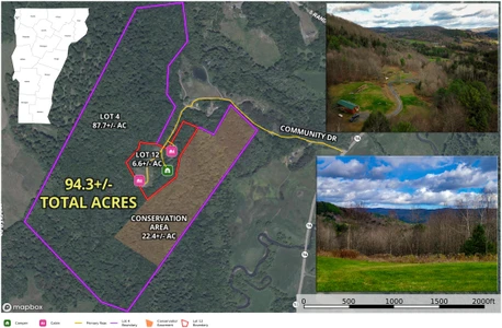
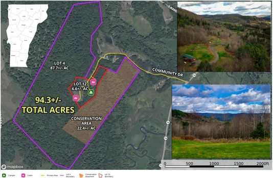
11/14/2025
$635,000
94.3 ac.
ACTIVE
Orange County - 566 Community Dr, Randolph, VT
Investors, homesteaders, tiny home enthusiasts, get ready to experience this unique 94.3+/- acre property in beautiful Randolph VT. Two legal parcels, 6.6+/- acres and 87.7+/- acres. The property includes a log cabin park model home, a custom tiny home, a new full homesite currently rented by a 5th wheeler and two tent platforms. A drilled well provides water to all of the structures. Power and DSL are connected to the tiny homes with Fiber available and conduit installed. Seller rents the log cabin, tiny home and 5th wheeler site on a m-to-m basis. Tent platforms were not rented this year. There are (2) three-bedroom septic systems connected to the log cabin & 5th wheeler site. 4 bedrooms of extra capacity remain. Custom tiny home uses a composting toilet. Income approximately $3110 p/m with room for expansion. All of the 87.7+/- acres are in the Vermont Current Use tax reduction program for forestry. 87.7+/- acre lot is wooded with 22.4 acres of this being conserved for recreational/forestry use only. The remaining may be subdivided developed, etc. The 6.6+/- Acres is where all of the structures were built. The property is accessed by a beautiful private road (ROW) called Community Drive. Maintenance will be shared with two private homes and an Airbnb community. Very nice views from the log cabin area. Great opportunity to build your dream home and have rental opportunities on your property. Also for sale is a 5 lot Airbnb tiny home community see MLS#5057088.


06/23/2025
$875,000
34 ac.
ACTIVE
Rutland County - 21 Nickerson Rd, Brandon, VT
Amazing development opportunity on 34+/- acres located in the beautiful town of Brandon, VT. Strategically located between the Middlebury and Rutland employment areas, this lot could provide the much-needed housing expansion. Zoned primarily High-Density Multi-use with minimum lot size of 1/5th acre. The town confirmed that this lot will be in the new Tier 1B Act250 exempt area when implemented, greatly reducing permitting issues. Both municipal water and sewer are available on the frontage and the town has indicated with allocation letters that there is plenty of capacity. Power and high-speed internet on the frontages. Access to be via Carver St or Nickeson Rd so no state highway permit will be required. The property offers amazing mountain views, to the west from the ridgeline (with clearing), and to the southeast from the open bowl area (existing views). Teir 1B allows for up to 50 units, most if not all could have wonderful views. The revitalized Brandon downtown offers casual and fine dining, supermarket, shopping, and community health center. We have found the town officials excited about a housing development and extremely helpful. The seller says bring all opportunities and offers, they want to make this work for the community.

07/28/2025
$575,000
0.45 ac.
ACTIVE
Essex County - 3714 Maidstone Lake Road, Maidstone, VT
Charming Lakeside Retreat on Pristine Maidstone Lake! Escape to tranquility with this enchanting 2-bedroom, 2-bathroom home nestled on the picturesque shores of Maidstone Lake. This year-round haven features a spacious open-concept living area adorned with natural woodwork, including knotty pine walls and wide pine board flooring and breathtaking lake views through a stunning wall of windows. Step out onto your new deck, perfect for morning coffee or sunset gatherings, and enjoy 146 feet of private lake frontage complete with two docks. The primary bedroom offers direct access to a full bath and laundry room, while an additional bedroom and a stylish 3/4 bathroom complete the main level. Need extra space? The versatile attic area can serve as a cozy bunk room or ample storage. Outside, the level lawn is ideal for outdoor activities, featuring a charming firepit area for evening relaxation. A detached 2-bay garage with additional storage ensures all your needs are met. Recent upgrades include a new propane heating system, cable for Starlink Internet, a new dock, a whole house generator, and an extended driveway. This property is more than just a home; it's a lifestyle. Embrace the serene lakeside living you've always dreamed of! Don't miss your chance to experience the beauty and tranquility of year-round living on Maidstone Lake.
Copyright © 2026 PrimeMLS. All rights reserved. All information provided by the listing agent/broker is deemed reliable but is not guaranteed and should be independently verified.
12/03/2025
$475,000
2.51 ac.
ACTIVE
Franklin County - 540 U.S. 7, Lot#WP001, Swanton, VT
Highgate Home with Detached 2-Car Garage on 2.51 AcresWelcome to this versatile 2.51 acre property located along the U.S. Route 7 corridor, offering a practical combination of usable land, convenience, and flexibility for a variety of residential or personal needs. The parcel includes a single-family home positioned back from the roadway, providing a sense of privacy while still maintaining quick access to nearby services and major travel routes. The home offers two heat sources, providing options for seasonal comfort and added reliability. The residence offers functional space for full-time living, rental use, or as a base for future updates, renovations, or expansion plans that buyers may wish to explore.A notable feature of this property is the spacious detached 2-car garage, which provides ample room for vehicles, equipment, tools, or general storage needs. The garage layout also accommodates buyers who may require workshop space, a hobby area, or additional room for seasonal items. The home includes a nicely sized deck that expands the outdoor living area and creates a convenient spot for grilling, outdoor seating, or general relaxation while overlooking the surrounding yard.The 2.51 acres blend open yard space with light tree cover near the edges of the lot. This mix allows for a variety of outdoor uses, including gardening, small-scale homesteading, pet areas, play space, or general recreational activity. The acreage is manageable while still offering more land than a traditional residential parcel, and the natural buffer around the property adds a degree of separation from neighboring homes.The propertys location provides convenient access to essential amenities. Local shopping, dining, schools, and village services are only minutes away, and Interstate 89 is a short distance south, making travel to St. Albans, Burlington, and the Canadian border efficient. Nearby outdoor destinations such as Lake Champlain, the Missisquoi National Wildlife Refuge, and multiple trail systems offer additional recreational opportunities throughout the year.Buyers should conduct due diligence regarding zoning, utilities, permitting, and intended uses to ensure the property aligns with future plans.


1
2
3
4
5
6
7

