Umatilla County, Oregon Land For Sale (22 results)
Want to post your listings on AcreValue? View Listing Plans
AcreValue offers multiple types of land for sale in Umatilla County, so if you’re looking for a new ranch, farm, recreational property, hunting ground, developmental property, or land investment you’ve come to the right place. Regardless of what your needs or objectives are for your land, we have a large inventory of available parcels that are updated regularly. Therefore, it’s very likely that we have the perfect parcel that meets all the search criteria & specifications that you’ve been searching for. Additionally, because our land for sale listings are always being updated due to the frequency of land being sold or new land listings being put on the market, make sure that you are checking back with AcreValue regularly for updates. When you find the perfect land parcel and you are ready to take the next steps you can easily connect directly with the listing agent to help you facilitate your land purchase. Browse AcreValue's Oregon land for sale page to find more potential opportunities in Oregon that fit your needs. We wish you the best of luck in finding your next ranch, farm, recreational property, hunting ground, developmental property, or land investment.

10/01/2024
$975,000
59.43 ac.
ACTIVE
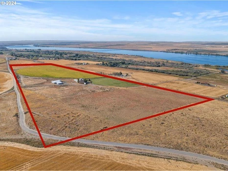
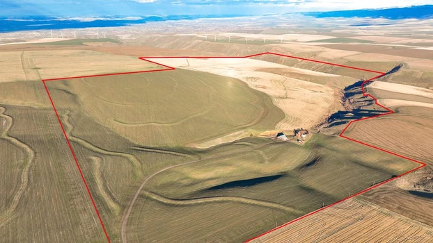
Umatilla County - 27696 U.S. 730, Umatilla, OR
59.43 Acres | Columbia River View Development Opportunity
Zoned RR4 Rural Residential (4-Acre Minimums)
Two Tax Parcels | Significant Subdivision Potential
This 59.43 acre property presents a rare large-acreage development opportunity overlooking the Columbia River. Comprised of two tax parcels and fully zoned RR4 (Rural Residential 4 Acre Minimums), the property offers strong potential for phased rural residential subdivision.
With sweeping river views, natural topography, and privacy, the setting is ideally suited for estate-sized home sites designed to capture the surrounding landscape. Large contiguous tracts with this zoning and view corridor are increasingly difficult to find.
Development Highlights:
59.43 deeded acres
Two legal tax parcels
Zoned RR4 4-acre minimum lot size
Columbia River views
Existing access and infrastructure
Gently varied terrain offering multiple view-oriented build sites
Bordered by the West Extension Main Canal
Based on zoning parameters (subject to county planning approval), the property may support creation of multiple 4-acre parcels. A conceptual lot layout could capitalize on view corridors while maintaining privacy buffers and open space appeal.
Existing Improvements
The property includes substantial existing infrastructure that may provide flexibility during development planning:
5,730 sq ft industrial shop
3-story split-level residence with vaulted ceilings and exposed timber beams
Lower-level entertainment space
Multiple outbuildings, detached garage, carport, and equipment storage
Existing irrigation systems
Framework for pool (adaptable for amenity use or removal)
Developers may consider:
Retaining the primary residence as a flagship lot
Repurposing shop structures during phased build-out
Utilizing agricultural ground as interim holding income prior to full build-out
Agricultural Component
The property includes productive acreage, including pivot-irrigated ground (27 acres under pivot within the larger offering prior to subdivision). This provides optional holding income or land-banking flexibility while entitlement and engineering work progresses.
Strategic Opportunity
Rural residential development with Columbia River views remains limited in supply. With RR4 zoning already in place across the full acreage, this offering provides a head start compared to raw ground requiring zone changes.
Whether positioned as:
A phased 4-acre estate development
A private multi-home family compound
Or a hold-and-divide investment strategy
This property offers scale, views, infrastructure, and zoning alignment rarely available in one package.
Contact Baker City Realty for a full development discussion, zoning review, and access to supporting materials.


08/05/2024
$274,000
68.33 ac.
ACTIVE
Umatilla County - 0 Vacant Land, Weston, OR
Discover your own slice of paradise with this stunning recreational property located just north of Tollgate. Nestled amidst a lush, timbered landscape, this unique property offers unparalleled access to miles of public lands, perfect for outdoor enthusiasts and nature lovers alike. Only 2 miles from Tollgate and approximately 12 miles from the picturesque Jubilee Lake, it provides easy access to fishing, boating, and lakeside relaxation. The property boasts two convenient access routes and an internal trail system, allowing you to easily navigate around the property. The natural beauty of the area is breathtaking, and stunning views of the surrounding mountains, valleys, and multiple species of wildflowers paint the landscape with vibrant colors. Immediate access to vast expanses of public lands opens up additional opportunities for hunting, hiking, horseback riding, and more. The timbered terrain offers a tranquil, secluded environment perfect for camping and getting away from the hustle and bustle. This property is a rare find for those seeking a retreat into nature with all the conveniences of nearby attractions. Whether you're an avid outdoorsman, a wildflower enthusiast, or someone seeking a peaceful escape, this property promises to deliver an extraordinary experience.


04/21/2025
$539,000
317 ac.
ACTIVE
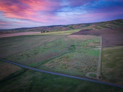
Umatilla County - Hansell Road, Weston, OR
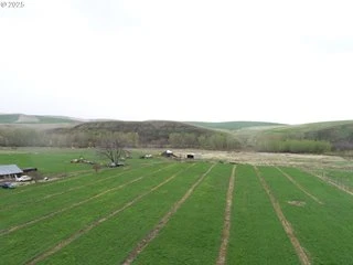
The Hansell Road Mountain property is 317 +/- acres of lower mountain heaven. High on top of the ridge top, the property is situated directly over the Umatilla River. The massive breaks of the canyon are breathtaking as you look outward over the 1400 ft gorge and directly into the heart of the Blues. Settlers long ago worked tirelessly clearing back trees in hopes of utilizing its ultra-rich soil for fields of wheat. Nowadays, the dim scars of an old plow are still visible in spots along the old edge of the fields. All the hard work to clear the land has naturally been undone. Pine trees have made their comeback and are perfectly scattered across the landscape, providing shade for the thick and vibrant stand of grass. Small clusters of old-growth forested areas remain in the less farmable areas and provide perfect habitat for wild game. This 3-parcel, buildable mountain property is the perfect chance to create your sanctuary out, away from it all!
317+/- contiguous acres with perimeter fence
3 separate parcels, 1 buildable
Power on property with a panel and several RV plugs already wired
Working Solar well
Horse pens
2 large year-round ponds
Graveled pad for an RV
Property location provides year-round access
Annual property taxes $447
Property is within the CTUIR tribal boundary
04/21/2025
$1,200,000
144.46 ac.
ACTIVE
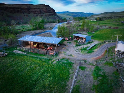
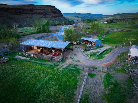
Umatilla County - 44743 McKay Creek Rd, Pilot Rock, OR
Well Springs Homestead:
Tucked away in the base of the Blue Mountain foothills and out of sight from the public eye is the Well Springs Homestead. Located just outside Pilot Rock, OR, this 144 +/- acre estate provides someone the spot to escape it all. Enjoy a beautiful 3,200+/- sqft custom-built home positioned to absorb the striking ever-shifting light from sunrises or sunsets bouncing from the red rock walls overlooking the beautiful McKay Creek. Embark on your journey towards self-sufficiency, where the rhythms of nature set the pace for a life lived close to the land. Overlooking McKay Creek, you'll find a property where wildlife flourishes and the land offers boundless possibilities. Water rights from Mckay Creek and an irrigation well allow water to be distributed throughout the irrigated production acres to grow various forage crops annually. Not far from the property is the town of Pilot Rock, where you will find a small community atmosphere with multiple stores, a gas station, excellent schools, and local services. Ready to support your endeavors, this is more than just a simple hobby farm-it's a canvas for your dreams to unfold. Embrace the call of the adventure and carve out your own path towards a life lived in the country with harmony and nature.
For tax planning purposes, the sellers intend to structure the sale with seller financing. The transaction would include a minimum of 50% down, with the sellers carrying the remaining balance for a short-term period.
Insko, Alan M & Ruth G
44743 McKay Creek Rd
Pilot Rock, OR 97868
Acres: 144.46 +/-
2025 Taxes: $4,365.75
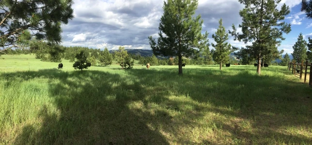
Wildlife:
Every day on the property brings a new experience. Situated at the edge of diverse habitats, this property showcases the beauty of seasonal transitions. Weather patterns shift, wildlife behavior changes, and the landscape transforms in color from one season to the next. Morning and evening light paints a stunning backdrop, making every day an adventure. The property owners have seen a variety of wildlife on the property, including deer, elk, cougar, fox, coyotes, an abundance of pheasants, geese, doves, and turkeys. The owner speaks of the wildlife activity as one of the main joys of the property. "You are far enough out from town, and with the Mckay creek below the property and natural springs running through the property, you see a bit of everything! It is beautiful and fun."
Fishing:
No two days are alike on the creek. Living at the bottom of a canyon accentuates seasonal changes. There is a twist or turn in the weather most days, plus the changing flow and character of the creek, and rapid changes in vegetation from one season to the next. The patterns of light on the canyon walls in the morning and as the sunsets are always changing. The colors of the canyon shift with changes in the weather, challenging every fisherman day by day. The Seller speaks of magical days on McKay Creek when the creek is full of active fish and the weather is perfect. Walk down to the creek side and try your luck fishing for trout open year-round.
Please note that McKay Creek is closed to angling for salmon and steelhead by permanent rule. McKay Creek falls within the Umatilla River Basin. (Additional rules or exceptions may apply, please refer to the Oregon Sport Fishing Regulations book for more information or call the local Oregon Department of Fish and Wildlife located in Pendleton, Oregon, at 541-276-2344 .)
As you move up the creek and across the reservation boundary regulations change and another license is needed-catch and release fly-fishing only with a single barbless hook. Please refer to the CTUIR fishing Regulations for more information.
Landowner Preference Tags:
Located in the NB-01 anterless deer unit & Ukiah Unit for elk, the property qualifies for two (2) Landowner Preference (LOP) tags for antlerless Deer and antlerless Elk under the Oregon Department of Fish and Wildlife guidelines. (Additional rules may apply-see the ODFW Big Game Hunting Regulations book or call the local Oregon Department of Fish and Wildlife located in Pendleton, Oregon, at 541-276-2344 .
This property offers excellent upland bird hunting opportunities, suitable for both families and individual hunters. The diverse habitat and seasonal changes create a dynamic environment, making each hunting outing unique. The landscape provides ideal conditions for a variety of upland game birds, and the picturesque surroundings enhance the overall experience. Its reputation for offering quality upland bird hunting experiences is supported by its diverse habitats, making it an ideal location for hunters seeking outdoor adventures.
2025-2026 Production Acres:
Primarily used as an irrigated hay operation. 42 +/- acres have been utilized to produce a variety of forage crops from year to year. Currently, of the 42 +/- FSA tillable acres approximately 28+/- acres are in their second year of rotation and have been seeded into a wheat crop for the 2026 crop year with the remaining tillable in grass pasture.
Historical Hay Averages: The historical average regarding hay for the farm is three cuttings for a total of 6+/- tons to the acre. The first cutting usually is after Memorial Day. Currently, the Seller is responsible for all aspects of the operation, including irrigation, spraying, fertilizer. This historically has been a great revenue source for the Sellers.
House:
4-Bedrooms
3-Bathrooms
3-Level with a daylight basement
3,240 +/- square feet
The quality custom-built home is a testament to superior craftsmanship and thoughtful design. Featuring new James Hardie siding and Coeur d'Alene windows and doors, and a newer designer composite roof, this residence exudes both durability and aesthetic appeal.
Upon entering, you are welcomed by a gracious foyer/sunroom that seamlessly transitions into an open-concept kitchen and family room. Bathed in natural light from large windows, the living space is warmed by a Lopi fireplace. The butler's pantry doubles as a laundry room and offers an impressive wall of floor-to-ceiling oak storage cabinets. Conveniently located across the hall, is a full bathroom. The main floor is directly connected to the two-car garage.
The upper level boasts four spacious bedrooms, each featuring large windowed dormers that flood the rooms with light and provide stunning views of the surrounding landscape. A sizable bathroom and a generous linen closet complete this floor.
The lower level is designed for both comfort and functionality. It includes a second family room adorned with a Sun Valley rock mantel surrounding a Blaze King wood stove, a picture window, and a sliding patio door that opens to another patio. Additionally, this level features an office with a closet and two mechanical rooms - one housing a water exchange heat pump for efficient heating and cooling, and the other equipped with food storage shelves.
Outdoor living is a delight with a raised deck and a paver patio perfect for enjoying breathtaking sunrises and tranquil full moons while listening to the soothing sounds of the creek.
- Custom railing throughout
- Beautiful woodstove
- Daylight basement
- Office room downstairs
- Oversized garage
- Newly finished deck off the back of the house
- Cement patio
- Underground Sprinklers
- Twenty tall Norwegian spruce trees provide privacy and wind protection.
Garden/orchard:
Just below the house you will find a big garden with raised beds and irrigation present. An orchard with five apple trees, an apricot tree, two pear trees, and a cherry tree, as well as a grape arbor, raspberry and strawberry raised beds, and fresh asparagus in the spring are just a few of the items that are present.
Shop:
The property includes a 24x36 two-level shop with new siding and metal roof, complete with a bathroom, shower, and washer/dryer hookups. Concrete floor, piped air supply and an additional two bay lean-to off the side make the shop very nice for most projects.
Hay Barn:
A 50x90x14-foot tall hay pole barn was built near the creek. The sellers have used this as a multipurpose barn that was designed to store hay while the outer perimeter was used to work and feed cattle. Currently the sellers use the pole barn for hay storage and to keep equipment dry during the winter months.
Machine Shed:
24x64 machine shed. The shed is used as storage for equipment and materials for the farm. The machine shed does have electricity with a dirt floor.
Cooling/Heating:
The house is well-insulated and fitted with an water exchange heat pump. Two wood stoves provide a secondary heat option.
Septic:
There are two 1,000 +/- gallon cement septic tanks that are connected together on the property. The system starts at the main house and flows to the shop where a secondary tank is located 10 feet west of the shop. Both tanks are connected to the same drain field that is west of the shop as well. The first tank is located off the basement sliding glass door from the main house and is approximately 15 feet from the house. The septic system has had very light use by two people since it was installed. There have been no known septic issues, and it has not been pumped since being installed the seller stated. The system was designed with a larger family in mind.
Additional Personal property not included in the sale but negotiable:
- Two 12 x16' Storage Buildings
Utilities:
Electrical-Pacific Power
Propane- Morrow County Grain Growers
Garbage- Eastern Oregon Waste Management
The phone landline is the primary source of contact.
Cell Service:
T-Mobile has the best service for the property. The Seller does have cell phone calling through both Wifi & LTE service with T-Mobile. Buyer to do further due diligence as to coverage area carriers.
WiFi- W-Tech link
Zoned: EFU; AG-2
Water:
1- Creek; McKay Creek- 1-mile +/- through the middle of the property.
2- Wells; 1-Domestic & Irrigation, 1-Irrig

01/15/2026
$2,875,000
994.09 ac.
ACTIVE
Umatilla County - 80539 Zerba Rd, Athena, OR
The Waterman Dryland Whitney Farm
Athena, Oregon
$2,875,000.00
Property:
The Waterman Dryland Whitney Farm consists of approximately 994.09 deeded county acres located just north of Athena, Oregon, in one of Umatilla County's most sought-after dryland farming areas due to its productive soils and reliable rainfall. Of these, an estimated 734.42 mapped FSA tillable acres are currently leased and actively farmed on an annual basis. The property is zoned Exclusive Farm Use (EFU) and has historically supported a variety of crops, with winter wheat serving as the primary rotation, producing typical yields ranging from approximately 80 to 120 bushels per acre depending on the year.
Improvements include a 1920s farmhouse and barn, with Pine Creek running through the property. The farm also qualifies for Landowner Preference hunting tags. With productive acreage, water features, and existing infrastructure, this property is well positioned for a wide range of agricultural, recreational, or long-term investment opportunities.
Location:
The Waterman Whitney Dryland Farm is situated just north of Athena, OR. The property spans over two taxlots with access coming from Zerba Road. Please refer to the aerial maps for specific entry points and layout.
Legal Identification of Subject Property:
(1 of 2)Tax Lot 5N3400-00-08600 -320.00 Ac
Parcel ID: 119887 (Umatilla County)
(2 of 2) Tax Lot 5N3500-00-05000-674.09 Ac
Parcel ID: 119928 (Umatilla County)
Acreage Breakdown:
Total County Deeded Acres: 994.09
Tillable Acres: 734.42
Leases:
2025-2026-Lease Crop-Share-
The land is leased with a local farmer, year-to-year.
No other known leases.
United States Department of Agriculture - Farm Service Agency:
Farm - 5747
Tract - 61
Crop Ground:
According to the FSA mapping, the property has a total of 734.42 +/- tillable production acres. 1/2 the property is currently being farmed annually as a wheat/fallow rotation, the 2025-2026 crop is winter dryland wheat. Insurance APH yield averages 86 B/U with historic yields ranging every other year 80's then 120's. Annual rainfall shows 15-17" +/- total precipitation for the area.
Soils:
The soils consist predominantly of Walla Walla silt loam.
- 114B - 1 to 7% slopes: 312.5 acres (30.26%)-Walla Walla Silt Loam
- 114C - 7 to 12% slopes: 181.5 acres (17.57%)-Walla Walla Silt Loam
- 60F - 35 to 70% slopes: 111.2 acres (10.77%)-Nansense Silt Loam
- 115D - 12 to 25% north slopes: 108.6 acres (10.52%)-Walla Walla Silt Loam
Elevation ranges from approximately 1,900 to 1,600 feet above sea level.
Improvements:
House- 1920's 1866+/- Sqft. Needs improvments- Sold "AS-IS"
Water:
One Domestic well that survices the house is on the property. Condition is unkown to the Seller.
No irrigation rights are known.
Taxes:
- 2025 Tax Amount: $9,110 +/-
Landowner Preference Tags:
Located in the new 2026 Helix Hunt Area HX-01 (Formally known as the Columbia Basin Unit), the property qualifies for two (2) Landowner Preference (LOP) tags for Deer under the Oregon Department of Fish and Wildlife guidelines. (Additional rules may apply-see the ODFW Big Game Hunting Regulations book or call the local Oregon Department of Fish and Wildlife located in Pendleton, Oregon, at 541-276-2344 .
This property offers excellent upland bird hunting opportunities, suitable for both families and individual hunters. The diverse habitat and seasonal changes create a dynamic environment, making each hunting outing unique. The landscape provides ideal conditions for a variety of upland game birds, and the picturesque surroundings enhance the overall experience. Its reputation for offering quality upland bird hunting experiences is supported by its deeb draws and diverse habitats, making it an ideal location for hunters seeking outdoor adventures.
Topography:
The tilled portions of the property are flat to gently sloping to some steep farm ground, which is typical of the area.
Mineral Rights:
The owner does not warrant there are any mineral rights available. However, any mineral or geothermal rights owned by the seller are included as part of the property being offered for sale.
Zoning:
Property is zoned EFU, exclusive farm use. For complete zoning information, contact the Umatilla County Planning Department at 541-278-6252 .
152.055 DESCRIPTION AND PURPOSE.
The purposes of the EFU, Exclusive Farm Use Zone, are to preserve and maintain agricultural lands for farm use, including range and grazing uses, consistent with existing and future needs for agricultural products, forest and open spaces; to conserve and protect scenic resources; to maintain and improve the quality of air, water and land resources of the county and to establish criteria and standards for farm uses and related and supportive uses which are deemed appropriate. It is also the purpose of this use zone to provide the automatic farm use valuation for farms, which qualify under the provisions of ORS Chapter 308. The provisions in this use zone are subject to automatic legislative amendments as described in 152.004. (Ord. 2005=02, passed 1-5-2005)
Ownership & Title:
The property is currently held by David & Jon Whitney
11430 99th PL NE Unit 2, Kirkland, WA 98033
Access:
The property can be accessed north from Athena on waterman road then turn east on to Zerba Road.
Distances To Other Cities:
Athena, OR -4+/- Miles
Walla Walla, WA -27 +/- Miles
Pendleton, OR -22 +/- Miles
Spokane, WA -201 +/- Miles
Boise, ID -237+/- Miles
Contact Information:
Whitney Land Company
101 SE 3rd St, Pendleton, OR 97801
(541) 278-4444
Umatilla County:
Umatilla County was created on September 27, 1862, out of a portion of Wasco County. Umatilla is an Indian term meaning "rippling water" or "water rippling over sand" and has provided the name both for the county and its major river. Lewis and Clark and pioneers traveling the Oregon Trail passed through the area. The gold rush of 1862 brought miners and stock raisers to the mountains and grasslands of Umatilla County. The county expanded after the coming of the railroad in 1881 and the area was open to the development of dry land wheat farming. The fertile land of Umatilla County gives a strongly agricultural base to the county's economy. Fruit, grain, timber, cattle, and sheep are important agricultural products. Recreation, primarily in the Blue Mountains, and tourism, most notably for the annual Pendleton Round-Up rodeo, are also important to the local economy.

06/27/2025
$300,000
73.3 ac.
ACTIVE
Umatilla County - 000 Motanic Road, Pendleton, OR
Blue Mtn Foothill CRP Homesite
Price: $300,000
Overview:
Located just beyond the city limits of Pendleton, Oregon, at the base of the scenic Blue Mountain foothills, the Blue Mtn Foothill CRP Homesite offers 73.30 acres of flat and gently rolling native grassland. Once used as productive farmland, the property is now enrolled in the Conservation Reserve Program (CRP), providing annual returns to the landowner. Elevated portions of the acreage showcase expansive western views overlooking the scenic McKay Valley making it an ideal spot to build a home.. Positioned within the boundaries of the Confederated Tribes of the Umatilla Indian Reservation, this property combines income potential with a peaceful rural setting.
Explore the opportunity to own land that offers both long-term value and a unique connection to Eastern Oregon's natural beauty.
Homesite:
The property's AG2 (Farm/Pasture) zoning under CTUIR's land development code allows for a singlefamily dwelling with accessory uses, including manufactured homes, and Accessory Dwelling Units (ADUs) per Section 3.445(14). This means a buyer may have the opportunity to build both a primary residence and an ADUsuch as a guest house, rental unit, or caretaker's quarterssubject to approval through the CTUIR Planning Department. Permitting is required and processed by the Tribal Planning Office, which reviews zoning classification and issues development permits. A buyer should plan for coordination with CTUIR early in the process to confirm design and site requirements, but the existing AG2 designation positions the property well structure residential development.
It should be noted- A portion of the property is enrolled in the Conservation Reserve Program (CRP). Buyers interested in building will need to work with the Natural Resources Conservation Service (NRCS) to remove the intended homesite from the CRP contract. Buyers are responsible for all due diligence related to eligibility, process, and any associated penalties, and agree to hold Seller harmless from any claims, costs, or obligations arising from the removal or development process.
Planning/Building:
The Tribal Planning Office will generally be your first stop if you want to build on the property. The current Planning & Building staff will help ensure sure all projects on the Umatilla Indian Reservation have the necessary permits, and they review all proposed projects for adherence to the CTUIR Land Development Code and all the adopted Building Codes. Once permits are issued, Planning & Building staff also provides inspection services for ongoing work on constructed, renovated, or demolished buildings. Buyer to do own Due Diligence with the Tribal Planning Department to ensure Buyer's satisfaction of the buildable aspect of the property. 541-276-3099 -Tribal Planning Department
Buyer(s) should review the Sub-Chapter AG-2 zoning description of the Land Development Code for the Confederated Tribes of the Umatilla Indian Reservation and Development Permit Process as part of their Due Diligence for building on the property.
Acreage Breakdown:
Total County Deeded Acres: 73.30
Tillable / CRP Acres: (FSA Reported) Tract-76.21
CRP Acres: 75.99
Leases:
Currently-USDA-CRP Contract. No other known leases.
United States Department of Agriculture Farm Service Agency:
Farm 4920
Tract 2719
Crop Ground:
According to the FSA mapping, the property has a total of 76.21 +/- tillable production acres. Of the 75.99 acres, currently,75.99+/- acres are enrolled in Conservation Reserve Program (CRP) through 9/30/2030. The annual rental rate per acre for 75.99+/- acres is $57.00 The annual contract payment is $4,331.00+/-. Payment:100%-Cliff Hoeft
Map & Tax Lot:
1S33-00-05100 Account Numbers: 102641
Jurisdiction: CTUIR-Confederated Tribes of the Umatilla Indian Reservation
County:
Umatilla County, OR
Zoned: AG-2
2024 Taxes: $334.94
Near By Towns:
Pilot Rock, OR- 10 +/- Miles
Pendleton, OR- 14 +/- Miles
Hermiston, OR- 41 +/- Miles
Tri-Cities, WA- 81 +/- Miles
Portland, OR- 220 +/- Miles
Boise, ID- 224 +/- Miles
Access:
Access to the property is from Motanic Road, a County maintained gravel road approximately 14 miles South East of Pendleton, OR.
Local Area Utilities:
Electrical-Umatilla Electric Co-op or Pacific Power
Propane- Morrow County Grain Growers
Garbage- Tribal Waste Management
Cell service LTE is located at the home site.
Wi-Fi: W-Tech link provides 4 Mbps or 8 Mbps plans in that area. Current monthly rates are $39 +/- per month for 4 Mbps and $63 +/- for 8 Mbps. Buyer to do own Due Diligence as to a service charge for bringing Wi-Fi to the home site. (If any).
Water:
There is no domestic water source established on the property. However, neighboring wells in the area have been drilled to depths of approximately 300 feet, with water typically encountered around 173 feet.
Pasture/Topography:
The property has approximately ten acres on the bottom that is flat ground. The remaining acreage is primarily gently slopped native CRP vegetation that aids as a cover crop for soil health, erosion control and wildlife.
Boundary lines/Fencing:
The property boundary is not fenced; Buyers are to do their Due Diligence to their own satisfaction with boundary lines.
Surrounding bordering land:
The property is bordered to the North by CTUIR Farmground. The Remaining borders are believed to be private landowners.
Wildlife:
The property owners have seen a variety of wildlife on the property, including deer, elk, upland game birds.
Confederated Tribes of the Umatilla Indian Reservation
The Umatilla reservation, Nicht-Yow-Way Country, is the home of the Cayuse, Umatilla and Walla Walla Bands of Native American Indians. When the leaders of the three tribes signed a treaty with the United States in 1855, they ceded 6.4 million acres of homeland in what is now northeastern Oregon and southeastern Washington. The 172,000-acre Umatilla Indian Reservation, almost half of which is owned by non-Indians, includes significant portions of the Umatilla River watershed.
Today the confederation, united under a single tribal government adopted in 1949, numbers over 2,800 members (2011). The Umatilla are governed by a Board of Trustees composed of nine members elected by the General Council. Tribal headquarters are located in Mission, just outside Pendleton, Oregon.
The Umatilla River and Grande Ronde rivers have been the focus of the tribe's fish restoration activities for more than a decade. Under the tribe's leadership, salmon were reintroduced in the Umatilla River in the early 1980s. The tribe, along with the state of Oregon, operates egg-taking, spawning, and other propagation facilities that are helping restore salmon runs. The tribe successfully reintroduced chinook salmon to the Umatilla River after 70 years of extinction.
Other river basins in which the tribe has co-management responsibilities are the Columbia, Snake, Walla Walla, Tucannon, Grande Ronde, John Day, and Imnaha. In recent times, tribal fisheries have occurred only on the Umatilla and Columbia rivers.
Umatilla County:
Umatilla County was created on September 27, 1862, out of a portion of Wasco County. Umatilla is an Indian term meaning "rippling water" or "water rippling over sand" and has provided the name both for the county and its major river. Lewis and Clark and pioneers traveling the Oregon Trail passed through the area. The gold rush of 1862 brought miners and stock raisers to the mountains and grasslands of Umatilla County. The county expanded after the coming of the railroad in 1881 and the area was open to the development of dry land wheat farming. The fertile land of Umatilla County gives a strongly agricultural base to the county's economy. Fruit, grain, timber, cattle, and sheep are important agricultural products. Recreation, primarily in the Blue Mountains, and tourism, most notably for the annual Pendleton Round-Up rodeo, are also important to the local economy.
Resources:

04/21/2025
$4,950,000
436.22 ac.
ACTIVE
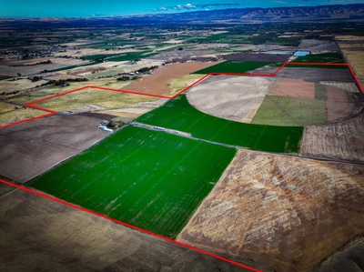
Umatilla County - 50671 Schubert Rd, Milton Freewater, OR
Key Umapine Irrigation Farm
Price: $4,950,000
Listing Brokers:
Todd Longgood, CLE (Owner) 541-571-3032
Christopher Stuvland, CLE (Owner) 541-969-5383
Introduction:
The Whitney Land Company is proud to offer an opportunity to own 436.22 contiguous acres with a Center Pivot just outside of Milton Freewater, OR. This unique property is ideally suited for investors or irrigation farmers looking for a well-established operation. The farm offers optimal elevations, gradual slopes, optimal soils, and strong water allocation.
The gently rolling landscape provides elevations between 700 feet and 850 feet. Approximately 85% of the property sits between 750 and 800 feet, and most of the acres have a slope between 6% and 12%. The property is within the Walla Walla Valley American Vineyard overlay (AVA).
This property showcases a highly uniform soil profile, featuring approximately 323 acres of Ellisforde silt loam and 43 acres of Walla Walla silt loam. The Ellisforde soils, formed in deep layers of loess over lacustrine sediments, extend from 15 to 40 inches without restrictive hardpans, promoting excellent root penetration and high water-holding capacity. These soil conditions make the land well-suited for a variety of permanent crops, allowing for optimal water management and efficient irrigation, ensuring long- term agricultural success.
This property is currently being leased out to a local farmer who is cultivating the land to grow a variety of both perennial crops and annual crops from year to year. The current water rights permit irrigation of approximately 132+/- acres under a single center pivot, sprinkler irrigation on roughly 236.22+/- acres, and flood irrigation across an additional 66+/- acres of pastureland. The two wells that are connected are capable of 2,500 gallons per minute. All water and irrigation equipment on the property has been well taken care of and consists of PVC mainline piping, filter systems, and an enclosed VFD control panel for the pivot.
Download the Brochure from the Whitney Land Company Website or contact the listing brokers for further information.

04/21/2025
$4,980,000
336 ac.
ACTIVE
Umatilla County - 71384 Hwy 207, Echo, OR
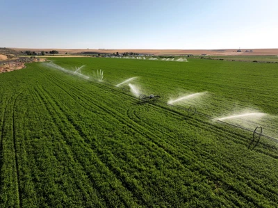
The Buttercreek Hay Farm is just 15 miles south of Hermiston Oregon and Interstate 84. Sitting strategically in the heart of the agriculturally rich Columbia Basin the farm consists of 336.85 +/- total acres. The Buttercreek valley is known for high yielding hay production and supplying dairy quality feed throughout the Pacific Northwest. Historically, the farm has produced grain and hay crops typical for the area.
WATER RIGHTS / IRRIGATION SYSTEM
The farm's water supply includes both surface water (Buttercreek ) and ground water with a total of 329+/- acres of water rights. According to Water Resources Department, the priority dates range from 1883 to 1903. The primary water delivery is flood irrigation. The point of diversion (POD) is on Buttercreek utilizing a series of well-maintained ditches spreading the water over leveled fields.
Throughout the irrigation season, the farm also relies on a pressurized system utilizing both well water and surface water. The pressurized system contains 90% mainline to wheel-line sprinklers with a small portion watered by hand-line sprinklers. There are three separate creek pump stations (POD) equipped with two 40-hp pumps, a 30-hp pump, as well as a 10-hp pump.
STRUCTURES / OUTBUILDINGS
The farm is comprised of three separate tax-lots.
2N2700 TL 2100
2N2700 TL 2000
2N2700 TL 1902
The main farmhouse was built in 1949, is approximately 1,440 sq/ft, including 3 bedrooms, 1 bath, and sits on tax lot 2100. Updated several years ago, it has a modest built interior and a very well-manicured outside yard area with a paved drive/parking area.
The supporting barn lot is equipped with a 30x40 garage, a 36x70 shop, both with poured concrete floors, and a supporting fuel system.
Not far across the field to the north sits the equipment lot and farm office which consists of a 1980 double-wide trailer. A well maintained fully permitted 60' working mechanical scale house is also included.
Quick Facts
336.85 +/- acres, 329+/- wet acres
1.5 miles of Butter Creek frontage
3 creek POD's / pump stations, 1 ground water well
90% irrigation serviced by wheel lines
Priority dates range from 1883 to 1903
Current crops include alfalfa and wheat.
1 main farmhouse (3 bd/1bath 1,440 sq/ft) with outbuildings
Paved drive/parking area
Farm office - 1980 mobile home (3 bedrooms/1bath) Working 60' scale with scale house
15 min travel from Interstate 84
3 separate tax lots
Taxes 2023 $5760

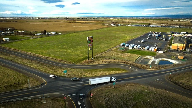
01/06/2026
$1,250,000
44.99 ac.
ACTIVE
Umatilla County - Hwy 207 & I84, Hermiston, OR
Just off Highway 207 and at Exit 182 off Interstate 84 sits 44.99 +/- acres of endless opportunity. The contiguous acreage sits strategically adjacent to Oregon Highway 207, the Space age Truck Stop and the Comfort Inn and Suites motel. On the property's north boundary sits the Panelview RV Park, a 10-acre solar powered RV stay facility. Along the south and west boundary sits Stanfield Meadows Road. Currently the property is Zoned EFU and holds 42 acres of water rights provided by the Westland Irrigation District with a 2025 water cost of $2,268. The property was previously watered by outer edge positioned, wiper designed, center pivots. Although the machines were dismantled, the power, pads and water delivery system are still intact.
Being only three miles east of the intersection of I-84 (serving Portland metro and all western Oregon travel) and I-82 (serving Seattle, Spokane, and travel to most of the state of Washington), this location provides not only strategic and quick access to these important roadways but also provides access to the millions of travelers that pass by daily. Exit 182 is one of four main off-ramps providing access to the City of Hermiston as well as the smaller communities to the south. This southern route involves new green energy builds, an incredible amount of agriculture movement as well as providing access for thousands of recreational enthusiasts. The above-mentioned options to the south include communities such as Heppner and Ione, the greater Columbia Basin and the Blue Mountains.
Hermiston Growth and Economy:
Hermiston, Oregon has experienced significant economic growth in recent years, positioning itself as a dynamic hub in Eastern Oregon. In 2024, the city set a new benchmark with commercial, industrial, and residential construction permits totaling $266 million, marking a record for development and investment. This surge in construction activity aligns with Hermiston's robust population growth; projections indicate a 33% increase from 2016 to 2035, with 80% of Umatilla County's growth occurring in the Greater Hermiston Area. This expansion is further supported by the area's strategic location near major freeways and proximity to the Tri-Cities in Washington, enhancing its appeal for logistics and data center operations. As Hermiston continues to grow, it attracts significant investments, diversifies its economy, and solidifies its status as a key economic center in the region.
Property Quick Facts:
- Strategically adjacent to existing Space Age Truck Stop, the Comfort Inn and Hwy 207 at I-84 exit 182.
- 42 +/- acres of Westland Irrigation Water rights
- 2025 property taxes $456.75

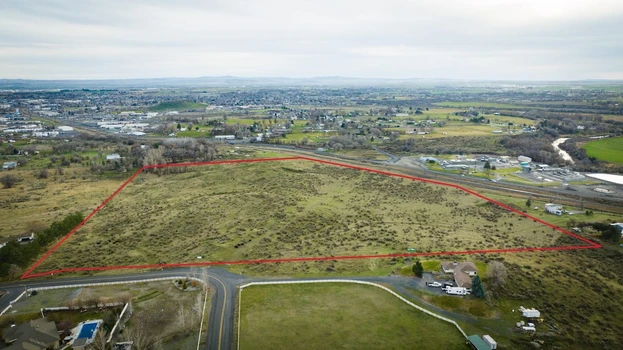
04/21/2025
$1,440,000
38.4 ac.
ACTIVE
Umatilla County - Umatilla River Road, Hermiston, OR
The Hermiston Development property is 38.4 +/- contiguous acres of vacant land, zoned R-1, located within the city limits of Hermiston, OR. Residing at the end of West Punkin Center Road, the location is perfect with quick access to the heart of town as well as an easy exit if your travels take you elsewhere. The property is situated on a mild sloping hill, allowing for excellent top to bottom southward views of the City of Hermiston, the northeastern Oregon's rolling foothills, as well as the more distant Blue Mountains.
Hermiston Growth and Economy:
Hermiston, Oregon, has experienced significant economic growth in recent years, positioning itself as a dynamic hub in Eastern Oregon. In 2024, the city set a new benchmark with commercial, industrial, and residential construction permits totaling $266 million, marking a record for development and investment. This surge in construction activity aligns with Hermiston's robust population growth; projections indicate a 33% increase from 2016 to 2035, with 80% of Umatilla County's growth occurring in the Greater Hermiston Area. This expansion is further supported by the area's strategic location near major freeways and proximity to the Tri-Cities in Washington, enhancing its appeal for logistics and data center operations. As Hermiston continues to grow, it attracts significant investments, diversifies its economy, and solidifies its status as a key economic center in the region.
IRS Opportunity Zone:
The property also sits inside a designated IRS Opportunity Zone, providing additional incentives and possible funding help for development projects. Here are the key benefits for investors in Opportunity Zones (Chatgpt):
An IRS Opportunity Zone is a designated area in the United States where investors can receive tax incentives to encourage long-term investments in economically distressed communities. These zones were created under the Tax Cuts and Jobs Act of 2017 to help stimulate economic development in low-income areas by offering tax breaks for investments in these regions.
Capital Gains Deferral: Investors can defer tax on capital gains from the sale of assets if the proceeds are invested in Qualified Opportunity Funds (QOFs) that invest in Opportunity Zones.
Exclusion of Gains: If the investment is held for at least 10 years, any capital gains from the Qualified Opportunity Fund's investment are excluded from taxes.
Exclusion of Gains from Original Investment: There are also benefits for gains on the sale of an investment in a Qualified Opportunity Fund after holding it for a set period. These incentives are meant to drive investment in infrastructure, housing, and businesses, helping to revitalize underdeveloped areas while providing investors with substantial tax savings.
West Punkin Center Extension Project:
The future looks bright for this property as proposed city expansion will bring one of Hermiston's largest expansion projects right to the doorstep of this land. The West Punkin Center Extension Project will extend the existing Punkin Center Road straight out, bridging the Umatilla River, and connecting with existing road system on the west side of the river, taking you straight to Interstate 82 access. This future development will provide a new main-line outlet for travelers and commuters alike, furthering the options and opportunities associated with this property.
Property Quick Facts:
-38.4 +/- acres zoned R-1 (minimum lot size 8,000sqft) within the city limits of Hermiston, OR.
- Property sits inside an IRS Opportunity Zone, providing additional tax breaks for every dollar spent on development or improvements.
- Adjacent to the future site of the West Punkin Center Extension Project which will extend the existing road, bridge the Umatilla River, and provide new direct access to I-82. This road will serve as a major Ingress/Egress option for Hermiston small vehicle travel.

02/20/2026
$1,813,500
577 ac.
ACTIVE
Umatilla County - Kings Corner Road, Helix, OR
OverviewThis property consists of approximately 570 +/- acres of tillable ground situated near Helix, Oregon. The land is well-suited for wheat production and offers expansive, open fields typical of the region's agricultural landscape. This non-contiguous property features two locations, one consisting of 488 contiguously farmed acres, with a smaller isolated 82-acre parcel to the north and east just a few miles away. This property is vacant crop land, the offering does not include houses, buildings, or supporting structures. Location: 5N3308-00-00400 (145766) 5N3200-00-04700 (104434) 5N3200-00-03500 (104355) The tracts are located in Umatilla County, in northeast Oregon. Access to the property is available via county-maintained roads, facilitating transportation of crops and equipment. The area is known for its productive wheat-growing conditions and is part of a larger farming community. In fact, this region is known as one of the strongest wheat producing regions in the pacific northwest.Topography and SoilThe land features gently rolling hills and broad, open plains. The soil is predominantly silt loam, characteristic of Eastern Oregon wheat country, providing good drainage and fertility for dry-land crop production. Elevation in the area typically ranges from 1,800 to 2,200 feet above sea level, which supports wheat growth and minimizes risk of flooding.Climate/RainfallAnnual rainfall in the Helix area averages 12 to 15 inches, which is sufficient for dry-land wheat farming but does limit the possibility of diversified crop rotation.Crop InformationThe land has a history of being used for wheat cultivation as its primary crop. There are no known conservation easements or restrictions on the property. FSA field maps and crop data are available upon request. The farm has been leased to a tenant who would finish out the 2026 crop year with an 80/20 crop share lease in place. Currently the land is being farmed in a crop/fallow annual rotation. The Seller states the 2025 average yield was 87 bushel/acre. The land in this region is suitable for expansion of wheat production or other dry-land crops, subject to soil and climate conditions.RecreationThe farm is located in a strong recreational corridor with activities such as hunting, fishing, boating or horseback riding all relevant to the region. The farm is in the Columbia Basin Game Management Unit and would be eligible for LOP tags. Both deer and upland game can be found on the farm. The farm is conveniently located as the mid-point between the mighty Columbia River (less than 30 miles away) and the beautiful Blue Mountains (less than 30 miles away). Your options are unlimited!ConclusionThis 570-acre parcel near Helix, Oregon, offers an excellent opportunity for dry-land wheat farming, featuring productive soils, established farming history, and convenient access to regional infrastructure. Its location and features make it a prime candidate for continued agricultural use.Property Taxes - $2002.00 (approx.)Zoning - EFU (Umatilla County)Nearby Cities- Pendleton, OR 18 miles- Walla Walla, WA 34 miles- Tri Cities, WA 57 miles- Portland, OR 220 miles- Boise, ID 240 milesTravel Eastern Oregon link - Choose your Adventure - Umatilla Co. - Visit Eastern Oregon
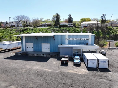
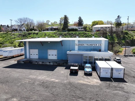
02/11/2026
$860,000
0.69 ac.
ACTIVE
Umatilla County - 524 SW 12th St, Pendleton, OR
Pendleton Office and Warehouse building now available for Sale or Lease. Great central location with close access to I-84 and Hwy 395. 8,734 SF warehouse facility featuring office space with a reception area, 4 private offices, storage room and restrooms. Clear span warehouse with mezzanine (not included in SF), 23' eve height and 3 dock-high roll-up doors. Fully enclosed lay down yard.
Property Highlights
Central location
Fully enclosed yard
Close proximity to I-84 and Hwy 395

08/15/2025
$615,000
24 ac.
ACTIVE
Umatilla County - 54884 DAY RD, Milton-Freewater, OR
Just two miles up the Walla Walla River from Milton-Freewater lies a rare and versatile opportunity for hobby farmers, vineyard dreamers, or anyone seeking a productive and peaceful lifestyle. This 24+ acre parcel boasts rich, irrigated farmland with excellent sun exposure and approximately 350 feet of scenic river frontage. Currently planted in alfalfa, the flat and fertile ground offers prime potential for vineyards, orchards, livestock, or continued crop production. With established water rights and direct access to the Walla Walla River, it's ready for a variety of agricultural pursuits. The parcel also offers the perfect setting to build your dream homecombining rural tranquility with easy access to both Milton-Freewater and the heart of Walla Walla wine country. A rare blend of natural beauty, agricultural productivity, and location make this a truly exceptional property.

10/15/2025
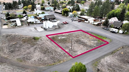
$59,500
0.22 ac.
ACTIVE
Umatilla County - 208 E. Main, Ukiah, OR
The East Main Ukiah lot is ready for whatever need you may have. From a potential home away from home, hunting base lodge, or your next business idea, this lot has power, water and sewer ready to go. Excellent location as it resides next to the grocery market, the Thicket Restaurant, as well as the card lock fuel station. This lot is dividable into two equal sized lots (buyer to verify). Zoned for residential or commercial. Priced to sell!

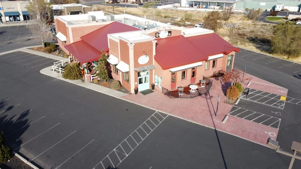
02/11/2026
$2,000,000
1.48 ac.
ACTIVE
Umatilla County - 1619 N 1st St, Hermiston, OR
This is the premium retail location in the market and is surrounded by established national and local retailers. Over 18,600 cars per day. This offering is for the building and real property only. Restaurant FF&E not included in price but can be negotiated. Owner would also consider a lease to own option.
PROPERTY HIGHLIGHTS:
1st St Frontage
Large lot with ample parking
18,600 ADT
AVAILABLE FOR LEASE at $8,500/mo NNN

04/05/2026
$890,000
4.28 ac.
ACTIVE
Umatilla County - 78662 Lloyd Road, Hermiston, OR
Beautiful 3-bedroom home with potential for a 4th bedroom, featuring 2 en suites and 3 bathrooms, all situated on acreage. This hard-to-find property is perfectly set up for a farm lifestyle, offering the space and functionality you ve been looking for. Walk into a large mud room ideal for keeping things clean and organized after a day outdoors. The home also features a large kitchen perfect for any cook, with plenty of room for preparing meals and gathering. The shop includes an office area, while the separate tack room and additional room provide excellent potential for a guest bedroom, hobby space, or extra storage. The home has been remodeled from top to bottom and showcases beautiful landscaping throughout. Additional features include a new HVAC system installed in 2022, gas appliances including range, furnace, on-demand hot water, and a double-sided fireplace. The property is fenced and cross-fenced, adding both function and value. Full water rights included. Don t miss this incredible opportunity.

04/02/2026
$649,900
1.04 ac.
ACTIVE
Umatilla County - 77286 Joyce Way, Echo, OR
Stunning Custom One-Level Home on 1.04 Acres in Echo Heights! Opportunities like this don t come up often in one of the area s most sought-after neighborhoods especially with this much space right on the edge of town. Inside, you ll find a thoughtfully designed layout that feels both open and inviting, with high ceilings and oversized windows that bring in great light and frame the surrounding views. The kitchen is a true centerpiece, offering granite countertops, generous prep space, and plenty of storage to keep everything within reach. The spacious primary suite is a standout feature, complete with a large en-suite bathroom, walk-in closet, and a relaxing soaker tub creating the perfect place to unwind at the end of the day. Step outside to a large back patio with pergola ideal for quiet mornings or hosting friends. The freshly updated landscaping, complete with new mulch, has the yard ready to pop this spring. The property truly sets itself apart with a separate shop with loft, a 3-car attached garage, and newly added RV hookups on the lower portion of the lot. With over an acre of ground, there s room for all your toys, future projects, or even that dream shop you ve been planning. Enjoy the perfect blend of space and convenience room to spread out, while still being just minutes from local amenities.
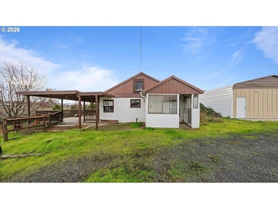

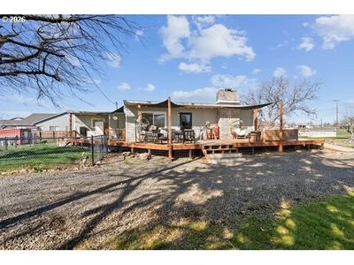
01/24/2026
$315,000
3.66 ac.
ACTIVE
Umatilla County - 85576 Highway 11, Milton Freewater, OR
A Rare Acreage Opportunity with Shop, Outbuildings & Endless Potential. Set on 3.66 usable acres in the heart of Oregon s scenic countryside, this single-level ranch-style home offers a compelling opportunity to create your own private retreat, hobby farm, or work-from-home compound. The true value shines beyond the main residence. A detached shop (approx. 720 sq ft) is equipped with power and water, ideal for equipment, projects, or small business use. Possible ADU???Two additional powered outbuildings (approximately 432 sq ft and 480 sq ft) provide flexible space for storage, livestock, workshops, or creative pursuits. Covered RV parking adds even more functionality for those with recreational vehicles, trailers, or farm equipment. The land itself offers room to breathe, featuring open pasture, established access, and a pond, adding a unique rural charm and peaceful backdrop. With RR-2 rural zoning and multiple structures already in place, this property presents exceptional upside for buyers seeking space, utility, and long-term potential.

03/25/2026
$508,000
1.84 ac.
ACTIVE
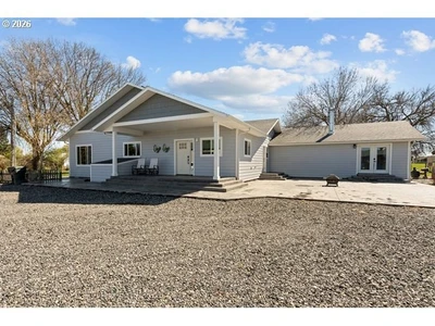
Umatilla County - 526 E Punkin Center Rd, Hermiston, OR
Cute and thoughtfully updated 3 bedroom (potential 4th) 2 bathroom home situated on just under 2 acres. This property has seen extensive improvements throughout, including updated plumbing, ?? newer windows, siding, and significant roof upgrades with wood replacement and new perimeter metal. Portions of the septic drain field have recently been replaced, along with the addition of a new water softener. The home was remodeled approximately 5 years ago, offering a functional layout with modern touches, while still maintaining character hardwood flooring remains in select areas beneath updated flooring. Additional upgrades include relocated interior water shut-off in the laundry room, new gravel added to the driveway, and AC extended into the newer addition for year-round comfort. The property is well-equipped for a variety of uses, featuring a workshop currently utilized as living quarters, a chicken coop, garden area, and an above-ground pool ideal for those seeking space, flexibility, and a bit of country lifestyle

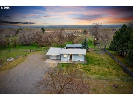
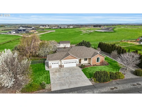
03/24/2026
$420,000
2.85 ac.
ACTIVE
Umatilla County - 33037 W Spearman Road, Hermiston, OR
3 bedroom, 2 bathroom home situated on just under 3 acres in a quiet country setting. Property offers ample space for a variety of uses, including potential homesteading or hobby farming. Functional layout with comfortable living areas and room to expand. Located in a peaceful rural neighborhood while still within reasonable distance to town amenities.
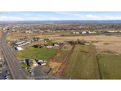

02/28/2026
$348,000
3.49 ac.
ACTIVE
Umatilla County - 0 E Airport Road, Hermiston, OR
Looking for a flat 3.49 Acres parcel? This piece has been waiting for your imagination! Zoned C-2 with Residential and Commercial on each side. Call your favorite Realtor for inf today.
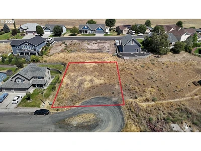

03/14/2026
$49,900
0.18 ac.
ACTIVE
Umatilla County - 0 SW 2nd Street 263926795, Pendleton, OR
One of the few remaining lots in the desirable Sunridge area this gently sloping parcel offers a rare opportunity to build your dream home in a well-established neighborhood. Tucked into one of the most sought-after developments in the region, it's perfectly positioned to enjoy long-term value as property prices continue to rise. Whether you're ready to break ground or looking for a smart investment, this is a piece of land worth holding onto.


1

